Dlouhá Třebová | |
|---|---|
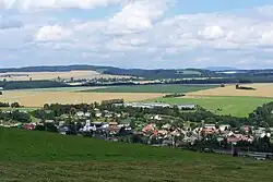 Panorama of Dlouhá Třebová | |
 Flag  Coat of arms | |
 Dlouhá Třebová Location in the Czech Republic | |
| Coordinates: 49°56′26″N 16°25′24″E / 49.94056°N 16.42333°E | |
| Country | |
| Region | Pardubice |
| District | Ústí nad Orlicí |
| First mentioned | 1304 |
| Area | |
| • Total | 10.44 km2 (4.03 sq mi) |
| Elevation | 345 m (1,132 ft) |
| Population (2023-01-01)[1] | |
| • Total | 1,318 |
| • Density | 130/km2 (330/sq mi) |
| Time zone | UTC+1 (CET) |
| • Summer (DST) | UTC+2 (CEST) |
| Postal code | 561 17 |
| Website | dlouhatrebova |
Dlouhá Třebová (German: Langentriebe) is a municipality and village in Ústí nad Orlicí District in the Pardubice Region of the Czech Republic. It has about 1,300 inhabitants.
History
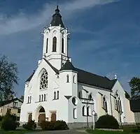
Church of Saint Procopius
The first written mention of Dlouhá Třebová is from 1304.[2]
Sights
The landmark of Dlouhá Třebová is the Church of Saint Procopius built in 1906.[2]
References
- ↑ "Population of Municipalities – 1 January 2023". Czech Statistical Office. 2023-05-23.
- 1 2 "O obci" (in Czech). Obec Dlouhá Třebová. Retrieved 2021-10-05.
External links
Wikimedia Commons has media related to Dlouhá Třebová.
This article is issued from Wikipedia. The text is licensed under Creative Commons - Attribution - Sharealike. Additional terms may apply for the media files.