| Sheep Mountain | |
|---|---|
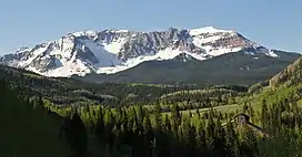 North aspect | |
| Highest point | |
| Elevation | 13,188 ft (4,020 m)[1][2] |
| Prominence | 108 ft (33 m)[1] |
| Parent peak | San Miguel Peak (13,752 ft)[3] |
| Isolation | 1.24 mi (2.00 km)[3] |
| Coordinates | 37°47′07″N 107°53′09″W / 37.7853689°N 107.8859530°W[4] |
| Geography | |
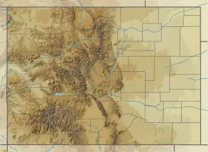 Sheep Mountain Location in Colorado  Sheep Mountain Sheep Mountain (the United States) | |
| Location | Dolores / San Miguel counties Colorado, US |
| Parent range | Rocky Mountains San Juan Mountains |
| Topo map | USGS Mount Wilson |
| Geology | |
| Type of rock | Extrusive rock |
Sheep Mountain is a 13,188-foot-elevation (4,020-meter) mountain summit located on the shared boundary of Dolores County with San Miguel County, in southwest Colorado, United States.[4] It is situated three miles south of Trout Lake and two miles southeast of Lizard Head Pass, on land managed by San Juan National Forest and Uncompahgre National Forest. Sheep Mountain is part of the San Juan Mountains which are a subset of the Rocky Mountains, and is west of the Continental Divide. Topographic relief is significant as the southwest aspect rises 3,200 feet (980 meters) above the Dolores River in approximately 2.5 miles. Neighbors include Golden Horn and Vermilion Peak to the east, and Lizard Head to the northwest. Sheep Mountain can be seen from the San Juan Skyway in the Lizard Head Pass and Trout Lake areas. The mountain's name, which has been officially adopted by the United States Board on Geographic Names, was in use in 1906 when Henry Gannett published it in A Gazetteer of Colorado.[4][5]
Climate
According to the Köppen climate classification system, Sheep Mountain is located in an alpine subarctic climate zone with cold, snowy winters, and cool to warm summers.[6] Due to its altitude, it receives precipitation all year, as snow in winter, and as thunderstorms in summer, with a dry period in late spring. Precipitation runoff from the mountain drains south into the nearby Dolores River, and north into tributaries of the San Miguel River.
Gallery
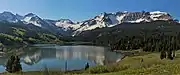 Sheep Mountain to right, with Trout Lake
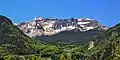 North aspect
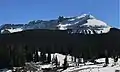 Sheep Mountain from Lizard Head Pass
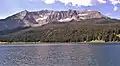 Sheep Mountain from Trout Lake
See also
- Mountains of Dolores County, Colorado
- Mountains of San Miguel County, Colorado
References
- 1 2 "Sheep Mountain, Colorado". Peakbagger.com.
- ↑ Stewart M. Green, 2013, Scenic Routes & Byways Colorado, Globe Pequot, ISBN 9780762795888, page 234.
- 1 2 "Sheep Mountain - 13,188' CO". listsofjohn.com. Retrieved 2021-07-12.
- 1 2 3 "Sheep Mountain". Geographic Names Information System. United States Geological Survey, United States Department of the Interior. Retrieved 2021-07-12.
- ↑ Henry Gannett, Gazetteer of Colorado, 1906, US Government Printing Office, page 153.
- ↑ Peel, M. C.; Finlayson, B. L.; McMahon, T. A. (2007). "Updated world map of the Köppen−Geiger climate classification". Hydrol. Earth Syst. Sci. 11. ISSN 1027-5606.
External links
- Weather forecast: National Weather Service
- Sheep Mountain NGS Data Sheet
- Sheep Mountain photo: Flickr