Ramsar County
Persian: شهرستان رامسر | |
|---|---|
County | |
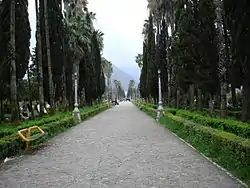 The Old Hotel | |
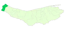 Location of Ramsar County in Mazandaran province | |
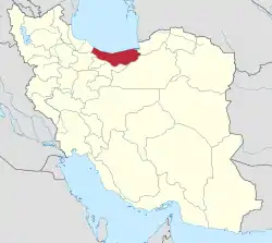 Location of Mazandaran province in Iran | |
| Coordinates: 36°45′N 50°34′E / 36.750°N 50.567°E[1] | |
| Country | |
| Province | Mazandaran |
| Capital | Ramsar |
| Districts | Central, Dalkhani |
| Area | |
| • Total | 729.80 km2 (281.78 sq mi) |
| Population (2016)[3] | |
| • Total | 74,179 |
| • Density | 100/km2 (260/sq mi) |
| Time zone | UTC+3:30 (IRST) |
| Ramsar County can be found at GEOnet Names Server, at this link, by opening the Advanced Search box, entering "9207254" in the "Unique Feature Id" form, and clicking on "Search Database". | |
Ramsar County (Persian: شهرستان رامسر) is in Mazandaran province, Iran. Its capital is the city of Ramsar.
At the 2006 census, the county's population was 67,675 in 19,666 households.[4] The following census in 2011 counted 68,323 people in 21,889 households.[5] At the 2016 census, the county's population was 74,179 in 25,312 households.[3]
Administrative divisions
The population history of Ramsar County's administrative divisions over three consecutive censuses is shown in the following table. The latest census shows one district, four rural districts, and two cities.[3]
After the 2016 census, Chehel Shahid and Jennat Rudbar Rural Districts were separated from the Central District in the establishment of Dalkhani District.[6]
| Administrative Divisions | 2006[4] | 2011[5] | 2016[3] |
|---|---|---|---|
| Central District | 67,675 | 68,323 | 74,179 |
| Chehel Shahid RD | 9,584 | 8,867 | 9,462 |
| Eshkevar RD | 1,600 | 1,246 | 991 |
| Jennat Rudbar RD | 627 | 785 | 551 |
| Sakht Sar RD | 6,305 | 6,169 | 6,462 |
| Ketalem and Sadat Shahr (city) | 17,900 | 18,962 | 20,716 |
| Ramsar (city) | 31,659 | 32,294 | 35,997 |
| Dalkhani District1 | |||
| Chehel Shahid RD | |||
| Jennat Rudbar RD | |||
| Dalkhani (city)2 | |||
| Total | 67,675 | 68,323 | 74,179 |
| RD: Rural District 1Established after the 2016 census[6] 2Formerly Galesh Mahalleh;[7] became a city after the 2016 census | |||
Wikimedia Commons has media related to Ramsar County.
References
- ↑ OpenStreetMap contributors (28 May 2023). "Ramsar County" (Map). OpenStreetMap. Retrieved 28 May 2023.
- ↑ Management and Planning Organization of Mazandaran, 2006
- 1 2 3 4 "Census of the Islamic Republic of Iran, 1395 (2016)". AMAR (in Persian). The Statistical Center of Iran. p. 02. Archived from the original (Excel) on 7 October 2021. Retrieved 19 December 2022.
- 1 2 "Census of the Islamic Republic of Iran, 1385 (2006)". AMAR (in Persian). The Statistical Center of Iran. p. 02. Archived from the original (Excel) on 20 September 2011. Retrieved 25 September 2022.
- 1 2 "Census of the Islamic Republic of Iran, 1390 (2011)" (Excel). Iran Data Portal (in Persian). The Statistical Center of Iran. p. 02. Retrieved 19 December 2022.
- 1 2 Jahangiri, Ishaq (5 March 2017). "Approval letter regarding country divisions in Ramsar city of Mazandaran province". RRK (in Persian). Ministry of Interior, Countil of Ministers. Archived from the original on 26 June 2021. Retrieved 24 November 2023.
- ↑ Mokhbar, Mohammad (24 December 1401). "Changing the name of Galesh village, Chehel Shahid Rural District, Dalkhani District, Ramsar County, Mazandaran province to Dalkhani". Qavanin (in Persian). Ministry of Interior, Council of Ministers. Archived from the original on 12 April 2023. Retrieved 28 May 2023.
This article is issued from Wikipedia. The text is licensed under Creative Commons - Attribution - Sharealike. Additional terms may apply for the media files.