Babol County
Persian: شهرستان بابل | |
|---|---|
County | |
 Filband | |
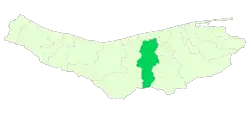 Location of Babol County in Mazandaran province | |
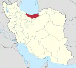 Location of Mazandaran province in Iran | |
| Coordinates: 36°16′N 52°36′E / 36.267°N 52.600°E[1] | |
| Country | |
| Province | Mazandaran |
| Capital | Babol |
| Districts | Central, Babol Kenar, Bandpey-e Gharbi, Bandpey-e Sharqi, Gatab, Lalehabad |
| Area | |
| • Total | 1,578.10 km2 (609.31 sq mi) |
| Population (2016)[3] | |
| • Total | 531,930 |
| • Density | 340/km2 (870/sq mi) |
| Time zone | UTC+3:30 (IRST) |
| Babol County can be found at GEOnet Names Server, at this link, by opening the Advanced Search box, entering "-3193722" in the "Unique Feature Id" form, and clicking on "Search Database". | |
Babol County (Persian: شهرستان بابل) is in Mazandaran province, Iran. Its capital is the city of Babol.[4]
At the 2006 census, the county's population was 464,538 in 125,187 households.[5] The next census in 2011 counted 495,472 people in 149,320 households.[6] At the 2016 census, the county's population was 531,930 in 174,351 households.[3]
Babol county was called Barforush in the 19th century.[7]
Dynasties from Babol County are:
- House of Pahlavi
- House of Karen
- House of Moradi (branch of the House of Suren)
- House of Suren
Administrative divisions
The population history of Babol County's administrative divisions over three consecutive censuses is shown in the following table. The latest census shows six districts, 13 rural districts, and seven cities.[3]
| Administrative Divisions | 2006[5] | 2011[6] | 2016[3] |
|---|---|---|---|
| Central District | 287,006 | 314,794 | 349,098 |
| Esbu Kola RD | 16,319 | 18,310 | 18,709 |
| Feyziyeh RD | 24,073 | 25,451 | 26,670 |
| Ganj Afruz RD | 22,792 | 23,480 | 23,024 |
| Amirkola (city) | 25,186 | 28,086 | 30,478 |
| Babol (city) | 198,636 | 219,467 | 250,217 |
| Babol Kenar District | 24,946 | 25,069 | 25,170 |
| Babol Kenar RD | 16,990 | 16,515 | 15,815 |
| Deraz Kola RD | 7,431 | 7,999 | 8,487 |
| Marzikola (city) | 525 | 555 | 868 |
| Bandpey-e Gharbi District | 25,577 | 25,876 | 26,233 |
| Khvosh Rud RD | 11,758 | 11,878 | 11,309 |
| Shahidabad RD | 10,879 | 10,681 | 9,182 |
| Khush Rudpey (city) | 2,940 | 3,317 | 5,742 |
| Bandpey-e Sharqi District | 32,522 | 33,508 | 35,232 |
| Firuzjah RD | 3,201 | 3,019 | 2,600 |
| Sajjadrud RD | 26,809 | 27,846 | 25,724 |
| Galugah (city) | 2,512 | 2,643 | 6,908 |
| Gatab District | 45,104 | 46,041 | 47,054 |
| Gatab-e Jonubi RD | 14,743 | 14,955 | 15,030 |
| Gatab-e Shomali RD | 23,405 | 23,844 | 24,650 |
| Gatab (city) | 6,956 | 7,242 | 7,374 |
| Lalehabad District | 49,383 | 50,184 | 49,142 |
| Karipey RD | 31,761 | 31,971 | 27,828 |
| Lalehabad RD | 17,197 | 17,790 | 17,323 |
| Zargar (city)1 | 425 | 423 | 3,991 |
| Total | 464,538 | 495,472 | 531,930 |
| RD: Rural District 1Name changed from Zargarmahelleh after the 2016 census[8] | |||
Wikimedia Commons has media related to Babol County.
References
- ↑ OpenStreetMap contributors (22 May 2023). "Babol County" (Map). OpenStreetMap. Retrieved 22 May 2023.
- ↑ "Management and Planning Organization of Mazandaran, 2006" (PDF). Archived from the original (PDF) on 16 November 2013. Retrieved 8 September 2012.
- 1 2 3 4 "Census of the Islamic Republic of Iran, 1395 (2016)". AMAR (in Persian). The Statistical Center of Iran. p. 02. Archived from the original (Excel) on 7 October 2021. Retrieved 19 December 2022.
- ↑ Habibi, Hassan (21 June 1369). "Approval of the organization and chain of citizenship of the elements and units of the divisions of Mazandaran province, centered in Sari city". Lamtakam (in Persian). Ministry of Interior, Defense Political Commission of the Government Council. Archived from the original on 14 January 2024. Retrieved 14 January 2024.
- 1 2 "Census of the Islamic Republic of Iran, 1385 (2006)". AMAR (in Persian). The Statistical Center of Iran. p. 02. Archived from the original (Excel) on 20 September 2011. Retrieved 25 September 2022.
- 1 2 "Census of the Islamic Republic of Iran, 1390 (2011)". Syracuse University (in Persian). The Statistical Center of Iran. p. 02. Archived from the original (Excel) on 19 January 2023. Retrieved 19 December 2022.
- ↑ "Welcome to Encyclopaedia Iranica".
- ↑ "The name of the city of Zargarmahalleh in Babol County was changed to Zargar". Islamic Republic News Agency (in Persian). Ministry of Interior, Cabinet of Ministers. 24 June 1400. Archived from the original on 5 August 2021. Retrieved 23 May 2023.
- اطلس گیتاشناسی استانهای ایران [Atlas Gitashenasi Ostanhai Iran] (Gitashenasi Province Atlas of Iran)
- Babol.tk [Babol.tk] ( Archived 2020-01-25 at the Wayback Machine)
This article is issued from Wikipedia. The text is licensed under Creative Commons - Attribution - Sharealike. Additional terms may apply for the media files.