Abbasabad County
Persian: شهرستان عباسآباد | |
|---|---|
County | |
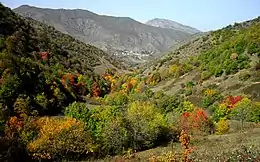 Abbasabad County in the fall | |
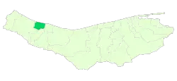 Location of Abbasabad County in Mazandaran province | |
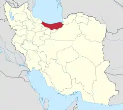 Location of Mazandaran province in Iran | |
| Coordinates: 36°39′N 51°10′E / 36.650°N 51.167°E[1] | |
| Country | |
| Province | Mazandaran |
| Capital | Abbasabad |
| Districts | Central, Kelar, Salman Shahr |
| Population (2016)[2] | |
| • Total | 52,832 |
| Time zone | UTC+3:30 (IRST) |
Abbasabad County (Persian: شهرستان عباسآباد) is in Mazandaran province, Iran. Its capital is the city of Abbasabad.[3]
After the 2006 National Census, Abbasabad District was separated from Tonekabon County in the establishment of Abbasabad County, which was divided into two districts of two rural districts each, with the city of Abbasabad as its capital.[3]
The census in 2011 counted 47,591 people in 14,568 households.[4] At the 2016 census, the county's population was 52,832 in 17,345 households,[2] by which time Kelarabad-e Sharqi Rural District and the city of Kelarabad had been separated from Kelarabad District in the establishment of Kelar District. Kelarabad District was renamed Salmanshahr District.[5]
Administrative divisions
The population history and structural changes of Abbasabad County's administrative divisions over two consecutive censuses are shown in the following table. The latest census shows three districts, five rural districts, and three cities.[2]
| Administrative Divisions | 2011[4] | 2016[2] |
|---|---|---|
| Central District | 22,946 | 25,436 |
| Langarud-e Gharbi RD | 2,818 | 3,011 |
| Langarud-e Sharqi RD1 | 8,529 | 8,943 |
| Abbasabad (city) | 11,599 | 13,482 |
| Kelar District | 10,969 | |
| Kelar-e Gharbi RD | 2,293 | |
| Kelar-e Sharqi RD2 | 2,409 | |
| Kelarabad (city) | 6,267 | |
| Salmanshahr District3 | 24,645 | 16,427 |
| Kelarabad-e Gharbi RD4 | 5,804 | 6,771 |
| Kelarabad-e Sharqi RD | 4,261 | |
| Kelarabad (city) | 5,926 | |
| Salman Shahr (city) | 8,654 | 9,656 |
| Total | 47,591 | 52,832 |
| RD: Rural District 1Formerly Langarud Rural District[3] 2Formerly Kelarabad-e Sharqi[5] 3Formerly Kelarabad District[5] 4Formerly Kelarabad Rural District[3] | ||
References
- ↑ OpenStreetMap contributors (20 May 2023). "Abbasabad County" (Map). OpenStreetMap. Retrieved 20 May 2023.
- 1 2 3 4 "Census of the Islamic Republic of Iran, 1395 (2016)". AMAR (in Persian). The Statistical Center of Iran. p. 02. Archived from the original (Excel) on 7 October 2021. Retrieved 19 December 2022.
- 1 2 3 4 Davoodi, Parviz (3 March 2018). "Divisional reforms and changes in Mazandaran province". Laws and Regulations Portal of the Islamic Republic of Iran (in Persian). Ministry of Interior, Cabinet of Ministers. Archived from the original on 20 May 2023. Retrieved 20 May 2023.
- 1 2 "Census of the Islamic Republic of Iran, 1390 (2011)". Syracuse University (in Persian). The Statistical Center of Iran. p. 02. Archived from the original (Excel) on 19 January 2023. Retrieved 19 December 2022.
- 1 2 3 Rahimi, Mohammad Reza (4 May 2011). "Divisional reforms in Mazandaran province". Laws and Regulations Portal of the Islamic Republic of Iran (in Persian). Ministry of Interior, Defense Political Commission of the Government Board. Archived from the original on 22 May 2023. Retrieved 22 May 2023.
| Capital | |||||||||||||||||
|---|---|---|---|---|---|---|---|---|---|---|---|---|---|---|---|---|---|
| Districts |
| ||||||||||||||||