La Ferrière-Béchet | |
|---|---|
 | |
Location of La Ferrière-Béchet | |
 La Ferrière-Béchet  La Ferrière-Béchet | |
| Coordinates: 48°34′50″N 0°04′21″E / 48.5806°N 0.0725°E | |
| Country | France |
| Region | Normandy |
| Department | Orne |
| Arrondissement | Alençon |
| Canton | Sées |
| Intercommunality | Sources de l'Orne |
| Government | |
| • Mayor (2022–2026) | Christel Persehaye[1] |
| Area 1 | 13.79 km2 (5.32 sq mi) |
| Population | 244 |
| • Density | 18/km2 (46/sq mi) |
| Time zone | UTC+01:00 (CET) |
| • Summer (DST) | UTC+02:00 (CEST) |
| INSEE/Postal code | 61164 /61500 |
| Elevation | 199–390 m (653–1,280 ft) (avg. 300 m or 980 ft) |
| 1 French Land Register data, which excludes lakes, ponds, glaciers > 1 km2 (0.386 sq mi or 247 acres) and river estuaries. | |
La Ferrière-Béchet (French pronunciation: [la fɛʁjɛʁ beʃɛ]) is a commune in the Orne department in north-western France.
Geography
The commune is made up of the following collection of villages and hamlets, Verdray, La Tourainnerie, Les Hayes, Les Hauts Champs and La Ferrière-Béchet.[3]
It is 1,380 hectares (5.3 sq mi) in size. The highest point in the commune is 230 metres (750 ft).[4]
The commune is within the Normandie-Maine Regional Natural Park and Forêt d'Écouves.[5][6]
The Senneviere river, La Forêt stream and the Ponts Besnard stream are the three watercourses running through this area.[4]
Notable buildings and places
- Tourbière des Petits Riaux is a nature reserve set within a Peat bog, that features carnivorous plants.[7][8]
National heritage sites
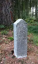
- Markers of Forêt d'Écouves a set of 80 markers positioned in the 18th century that mark the boundaries of the forest, they were registered as a Monument historique in 1987.[9]
See also
References
- ↑ "Répertoire national des élus: les maires" (in French). data.gouv.fr, Plateforme ouverte des données publiques françaises. 16 December 2022.
- ↑ "Populations légales 2021". The National Institute of Statistics and Economic Studies. 28 December 2023.
- 1 2 "La Ferrière-Béchet · 61500, France". La Ferrière-Béchet · 61500, France.
- 1 2 "Mairie de la Ferrière-Béchet et sa commune (61500)". Annuaire-Mairie. 26 October 2023.
- ↑ "rapport de charte" (PDF), parc-naturel-normandie-maine.fr/
- ↑ "MASSIF FORESTIER D'ECOUVES ET SES MARGES" (PDF). ZNIEFF.
- ↑ "La Tourbière des Petits Riaux LA LANDE-DE-GOULT : Normandy Tourism". Normandy Tourism, France.
- ↑ "Tourbière de la Lande-de-Goult". Ouest-France.fr. 27 August 2014.
- ↑ "80 bornes de la forêt d'Ecouves (également sur communes de Le Bouillon, La Chapelle-près-Sées, La Ferrière-Béchet, Fontenai-les-Louvets, La Lande-de-Goult, Radon, Rouperroux, Saint-Didier-sous-Ecouves, Saint-Gervais-du-Perron, Tanville et Vingt-Hanap..." monumentum.fr.
Wikimedia Commons has media related to La Ferrière-Béchet.
This article is issued from Wikipedia. The text is licensed under Creative Commons - Attribution - Sharealike. Additional terms may apply for the media files.