There are over 20,000 Grade II* listed buildings in England. This page is a list of these buildings in the district of Dover in Kent.
Buildings
| Name | Location | Type | Completed [note 1] | Date designated | Grid ref.[note 2] Geo-coordinates |
Entry number [note 3] | Image |
|---|---|---|---|---|---|---|---|
| Chilton House | Ash, Dover | House | Late 17th century | 11 October 1963 | TR2862558409 51°16′44″N 1°16′36″E / 51.278923°N 1.276777°E |
1054893 |  Upload Photo |
| Paramour Grange | Paramour Street, Ash | House | c.1600 | 13 October 1952 | TR2886161088 51°18′10″N 1°16′55″E / 51.302878°N 1.28187°E |
1070220 | Upload Photo |
| School Farm House | Guilton, Ash | House | Dated 1691 on wall ties | 13 October 1952 | TR2799458302 51°16′42″N 1°16′04″E / 51.278215°N 1.267676°E |
1051629 | Upload Photo |
| Wingham Barton Manor | Ash | Continuous jetty house | 15th century or earlier | 10 November 1963 | TR2738261205 51°18′16″N 1°15′39″E / 51.304521°N 1.260764°E |
1070203 | 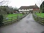 Wingham Barton Manor |
| Church of St George | Deal | Chapel of ease | 1706–16 | 1 June 1949 | TR3763252850 51°13′31″N 1°24′07″E / 51.225343°N 1.401996°E |
1253171 | 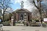 Church of St George |
| Church of St Leonard | Deal | Church | Norman | 1 June 1949 | TR3626751853 51°13′01″N 1°22′55″E / 51.21696°N 1.381827°E |
1343697 | 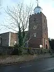 Church of St Leonard |
| Queen Anne House | Deal | House | Early 18th century | 1 June 1949 | TR3775052579 51°13′22″N 1°24′13″E / 51.222862°N 1.403503°E |
1069827 | Upload Photo |
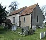
| Church of St Martin | Denton with Wootton | Parish church | 12th century | 22 August 1962 | TR2250746547 51°10′29″N 1°10′55″E / 51.174847°N 1.181842°E |
1363381 | 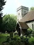 Church of St Martin |
| Church of St Mary Magdalene | Denton with Wootton | Parish church | 13th century | 22 August 1962 | TR2164246713 51°10′36″N 1°10′11″E / 51.176673°N 1.169589°E |
1070009 | 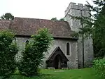 Church of St Mary Magdalene |
| Denton Court and Entrance Court | Denton with Wootton | House | 16th century | 27 August 1952 | TR2170046730 51°10′36″N 1°10′14″E / 51.176803°N 1.170428°E |
1363377 | 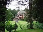 Denton Court and Entrance Court |
| Tappington Hall | Denton with Wootton | Jettied house | 16th century | 27 August 1952 | TR2100846239 51°10′22″N 1°09′37″E / 51.172662°N 1.160243°E |
1070011 | 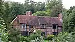 Tappington Hall |
| Church of St Peter and St Paul | Charlton-in-Dover, Dover | Church | 1891–93 | 27 October 1976 | TR3140142310 51°08′00″N 1°18′22″E / 51.133284°N 1.306136°E |
1273145 | 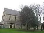 Church of St Peter and St Paul |
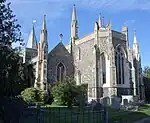
| Library, Dover College | Dover | School | 1880 | 30 June 1949 | TR3147741529 51°07′34″N 1°18′24″E / 51.126243°N 1.306719°E |
1069497 | Upload Photo |
| Maison Dieu House | Dover | House | 1665 | 30 June 1949 | TR3165241724 51°07′41″N 1°18′34″E / 51.127922°N 1.309341°E |
1069521 | 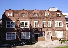 Maison Dieu House |
| Parish Church of St Andrew, Buckland | Dover | Church | Late 12th century | 30 June 1949 | TR3049142729 51°08′15″N 1°17′36″E / 51.137412°N 1.29342°E |
1069505 | 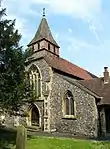 Parish Church of St Andrew, Buckland |
| Ruins of cloisters to west of the refectory of St Martin's Priory, Dover College | Dover | Cloister | Mid-12th century | 30 June 1949 | TR3152241560 51°07′35″N 1°18′27″E / 51.126503°N 1.307381°E |
1069496 | Upload Photo |
| School Chapel, Dover College | Dover | Guest house | Late 12th century | 30 June 1949 | TR3143641624 51°07′38″N 1°18′22″E / 51.127112°N 1.306195°E |
1343820 | Upload Photo |
| The School Hall, Dover College | Dover | Benedictine monastery | c.1139 | 30 June 1949 | TR3154241582 51°07′36″N 1°18′28″E / 51.126692°N 1.30768°E |
1343819 |  The School Hall, Dover College |
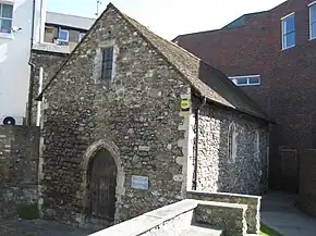
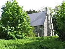
| St Edmund's Chapel | Dover | Chapel | 12th century | 17 December 1973 | TR3165641661 51°07′38″N 1°18′34″E / 51.127355°N 1.309357°E |
1070322 | |
| The Parish Church of St Mary the Virgin | Dover | Church | Early 12th-century tower | 30 June 1949 | TR3192041516 51°07′33″N 1°18′47″E / 51.125947°N 1.31303°E |
1069522 | |
| Brook House | Eastry | House | 1710 | 11 October 1963 | TR3121054568 51°14′36″N 1°18′41″E / 51.243401°N 1.311295°E |
1055854 | 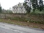 Brook House |
| Felderland House | Eastry | House | Early 18th century | 11 October 1963 | TR3206255908 51°15′18″N 1°19′28″E / 51.255084°N 1.324348°E |
1363307 | Upload Photo |
| Great Selson | Selson, Eastry | House | Mid-17th century | 11 October 1963 | TR3006055552 51°15′10″N 1°17′44″E / 51.252699°N 1.295479°E |
1038321 | 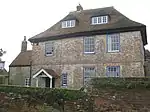 Great Selson |
| Heronden | Eastry | House | 1766 | 11 October 1963 | TR2956054265 51°14′29″N 1°17′15″E / 51.241347°N 1.287502°E |
1363272 | 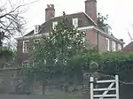 Heronden |
| Church of St Peter and St Paul | Eythorne | Parish church | c.1200 | 11 October 1963 | TR2795849705 51°12′04″N 1°15′42″E / 51.201052°N 1.261693°E |
1121964 | 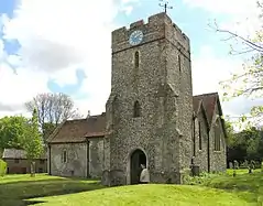 Church of St Peter and St Paul |
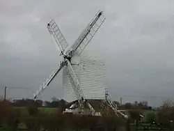
| Chillenden Windmill | Chillenden, Goodnestone | Post mill | 1868 | 11 October 1963 | TR2689954238 51°14′32″N 1°14′58″E / 51.242168°N 1.249427°E |
1111765 | |
| Church of All Saints | Chillenden, Goodnestone | Parish church | 12th century | 11 October 1963 | TR2695753594 51°14′11″N 1°14′59″E / 51.236364°N 1.249849°E |
1070283 | 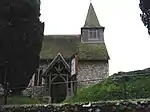 Church of All Saints |
| Dovecote about 100 metres north-west of Knowlton Court | Knowlton, Goodnestone | Dovecote | Early 18th century | 11 October 1963 | TR2807653394 51°14′03″N 1°15′57″E / 51.234122°N 1.265724°E |
1070289 | 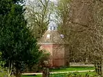 Dovecote about 100 metres north-west of Knowlton Court |
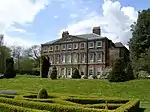
| Goodnestone Park | Goodnestone | House | c.1704 | 13 October 1952 | TR2533754342 51°14′37″N 1°13′38″E / 51.24372°N 1.227152°E |
1070296 | |
| The Dower House | Goodnestone | House | Late 18th century | 13 October 1952 | TR2542354478 51°14′42″N 1°13′42″E / 51.244907°N 1.228468°E |
1070257 | Upload Photo |
| The Dower House | Knowlton, Goodnestone | Dower house | Late 16th century | 11 October 1963 | TR2799453444 51°14′05″N 1°15′52″E / 51.234604°N 1.264583°E |
1336976 | Upload Photo |
| The Gabriel Richards Almshouses | Goodnestone | Almshouse | Mid-17th century | 13 October 1952 | TR2566354761 51°14′50″N 1°13′55″E / 51.247353°N 1.232079°E |
1070263 | 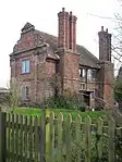 The Gabriel Richards Almshouses |
| Church of St Martin | Great Mongeham | Church | 12th to 15th century | 1 June 1949 | TR3461951504 51°12′52″N 1°21′29″E / 51.214506°N 1.358044°E |
1069782 | 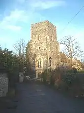 Church of St Martin |
| Church of St Martin of Tours | Guston | Parish church | 12th century | 22 August 1966 | TR3222944733 51°09′17″N 1°19′10″E / 51.154701°N 1.319511°E |
1070050 | 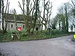 Church of St Martin of Tours |
| Ruins of St. Radegund's Abbey | Hougham Without | Abbey | 13th century | 22 August 1962 | TR2753741993 51°07′55″N 1°15′03″E / 51.131986°N 1.250802°E |
1070023 | 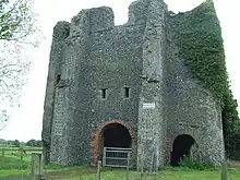 Ruins of St. Radegund's Abbey |
| St. Radegund's Abbey Farmhouse and outhouse | Hougham Without | Abbey | Early 13th century | 17 August 1952 | TR2753841955 51°07′54″N 1°15′03″E / 51.131644°N 1.250792°E |
1068889 | .jpg.webp) St. Radegund's Abbey Farmhouse and outhouse |
| Stone barn at St. Radegund's Abbey Farm, about 65 metres south of well house | Hougham Without | Barn | 13th century | 28 May 1987 | TR2754841862 51°07′51″N 1°15′03″E / 51.130805°N 1.250876°E |
1356562 | 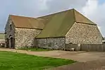 Stone barn at St. Radegund's Abbey Farm, about 65 metres south of well house |
| Barn about 20 metres north-east of Jossenblock | East Langdon, Langdon | Aisled barn | 1725 | 23 April 1987 | TR3338646179 51°10′02″N 1°20′13″E / 51.167211°N 1.336963°E |
1070052 | Upload Photo |
| Church of St Augustine | East Langdon, Langdon | Parish church | 11th century | 23 April 1987 | TR3331045980 51°09′56″N 1°20′09″E / 51.165455°N 1.335749°E |
1070054 | 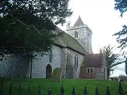 Church of St Augustine |
| Jossenblock | East Langdon, Langdon | House | 17th century or earlier | 22 August 1966 | TR3338246146 51°10′01″N 1°20′13″E / 51.166916°N 1.336885°E |
1070051 | Upload Photo |
| Langdon Abbey | Langdon | Abbey | 12th century and later | 27 August 1952 | TR3263446960 51°10′28″N 1°19′36″E / 51.174528°N 1.326731°E |
1070055 | |
| St. Mary (formerly listed as Church of St Mary Virgin) | Lydden | Parish church | 12th century | 22 August 1962 | TR2642945710 51°09′57″N 1°14′14″E / 51.165794°N 1.237329°E |
1342746 |  St. Mary (formerly listed as Church of St Mary Virgin) |
| Old St Albans Court and wall | St Albans Court, Nonington | House | 1556 | 11 June 1986 | TR2632252525 51°13′37″N 1°14′24″E / 51.227019°N 1.240093°E |
1070243 | Upload Photo |
| Southdown Cottage | Easole Street, Nonington | Hall house | 13th century | 23 April 1980 | TR2608952064 51°13′23″N 1°14′11″E / 51.222972°N 1.236471°E |
1070271 | 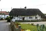 Southdown Cottage |
| Barn about 20 metres north of Northbourne Court | Northbourne | Barn | 17th century | 13 October 1952 | TR3364552251 51°13′18″N 1°20′41″E / 51.221611°N 1.344609°E |
1237002 | Upload Photo |
| Betteshanger House, Northbourne Park School | Betteshanger, Northbourne | House | 1856–1886 | 5 June 1973 | TR3104452538 51°13′31″N 1°18′27″E / 51.225245°N 1.307613°E |
1236988 | 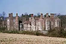 Betteshanger House, Northbourne Park School |
| Church of St George | Ham, Northbourne | Parish church | 13th-century fenestration | 24 March 1987 | TR3261854773 51°14′41″N 1°19′54″E / 51.244669°N 1.331565°E |
1264237 | 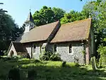 Church of St George |
| Garden walls at Northbourne Court | Northbourne | Walled garden | c.1616 | 13 October 1952 | TR3370052184 51°13′16″N 1°20′43″E / 51.220987°N 1.345352°E |
1237003 | 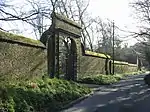 Garden walls at Northbourne Court |
| Vine Farmhouse | Northbourne | House | 17th century | 13 October 1952 | TR3341652109 51°13′14″N 1°20′28″E / 51.22043°N 1.341243°E |
1237301 | |
| Elmstone Church (dedication unknown) | Elmstone, Preston | Parish church | 12th century | 11 October 1963 | TR2614960284 51°17′48″N 1°14′33″E / 51.296743°N 1.242522°E |
1070154 | 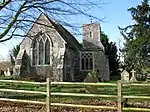 Elmstone Church (dedication unknown) |
| Church of St Mary the Virgin | Church Lane, Ripple | Parish church | 1861 | 24 March 1987 | TR3503150207 51°12′10″N 1°21′47″E / 51.202695°N 1.363083°E |
1264330 | 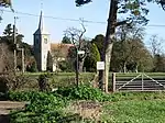 Church of St Mary the Virgin |
| Ripple Court and outhouses in rear courtyard | Ripple | House | 1796–1806 | 11 October 1963 | TR3493048811 51°11′25″N 1°21′39″E / 51.190205°N 1.360727°E |
1237011 | Upload Photo |
| Winklandoaks Farmhouse | Ripple | Farmhouse | Late 17th century | 11 October 1963 | TR3399348423 51°11′14″N 1°20′50″E / 51.187106°N 1.34709°E |
1264333 | 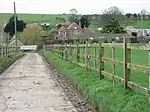 Winklandoaks Farmhouse |
| Crabble Mill | River | Flour mill | 1812 | 5 June 1972 | TR2975343184 51°08′30″N 1°16′59″E / 51.141793°N 1.283179°E |
1070318 | 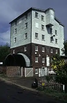 Crabble Mill |
| Bartlemas | Stone Cross, Sandwich | House | Early 19th century | 19 May 1950 | TR3308057572 51°16′11″N 1°20′24″E / 51.269606°N 1.339994°E |
1069714 | Upload Photo |
| Bridge (site of the Sandown Gate) | Sandwich | Moat | 1650–1675 | 23 April 1976 | TR3347258038 51°16′25″N 1°20′45″E / 51.273629°N 1.345908°E |
1122658 | 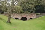 Bridge (site of the Sandown Gate) |
| Curfew House | Sandwich | House | 18th century | 19 May 1950 | TR3311158148 51°16′29″N 1°20′27″E / 51.274764°N 1.340813°E |
1069567 |  Curfew House |
| Delf House | Sandwich | House | 17th century | 19 May 1950 | TR3290458232 51°16′32″N 1°20′16″E / 51.275603°N 1.337905°E |
1069712 | Upload Photo |
| Invicta House, Ye Olde King's Arms | Sandwich | House | Dated 1592 | 19 May 1950 | TR3292658438 51°16′39″N 1°20′18″E / 51.277443°N 1.338354°E |
1069542 | 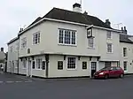 Invicta House, Ye Olde King's Arms |
| Luckboat House | Sandwich | House | Dated 1771 | 19 May 1950 | TR3314758023 51°16′25″N 1°20′28″E / 51.273627°N 1.341247°E |
1069639 | Upload Photo |
| Manwood Close, Manwood Court | Sandwich | House | 1564 | 19 May 1950 | TR3276858519 51°16′42″N 1°20′10″E / 51.278234°N 1.336146°E |
1069546 | .jpg.webp) Manwood Close, Manwood Court |
| No 52 (New Street), including the outhouse to north | Sandwich | House | Mid-18th century | 19 May 1950 | TR3309757990 51°16′24″N 1°20′26″E / 51.273351°N 1.34051°E |
1343786 | Upload Photo |
| Pellicane House | Sandwich | House | 15th century | 19 May 1950 | TR3314958170 51°16′30″N 1°20′29″E / 51.274946°N 1.341371°E |
1335883 | 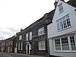 Pellicane House |
| Petersham House | Sandwich | House | Late 18th century | 19 May 1950 | TR3314558032 51°16′25″N 1°20′28″E / 51.273709°N 1.341224°E |
1105686 | Upload Photo |
| Richborough House | Sandwich | House | 18th century | 19 May 1950 | TR3292858315 51°16′35″N 1°20′18″E / 51.276338°N 1.338303°E |
1069762 | Upload Photo |
| Stuart House | Sandwich | House | Early 19th century | 23 April 1976 | TR3288958307 51°16′35″N 1°20′16″E / 51.276282°N 1.33774°E |
1069708 | Upload Photo |
| The Admiral Owen Public House | Sandwich | Public house | 15th century | 19 May 1950 | TR3315758231 51°16′32″N 1°20′29″E / 51.27549°N 1.341526°E |
1069656 | %252C_Sandwich.JPG.webp) The Admiral Owen Public House |
| The Dutch House | Sandwich | House | Late 17th century | 19 May 1950 | TR3315657986 51°16′24″N 1°20′29″E / 51.273291°N 1.341352°E |
1105688 | 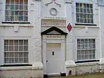 The Dutch House |
| The Guildhall | Sandwich | Guildhall | 1579 | 19 May 1950 | TR3295658147 51°16′29″N 1°20′19″E / 51.274818°N 1.338594°E |
1069731 | |
| The Haven Guest House | Sandwich | House | Probably early 15th century | 19 May 1950 | TR3300258319 51°16′35″N 1°20′22″E / 51.276344°N 1.339365°E |
1069695 | Upload Photo |
| The Red Cow Public House | Sandwich | Jettied house | 16th century | 29 April 1970 | TR3288658139 51°16′29″N 1°20′15″E / 51.274775°N 1.337587°E |
1106323 | 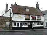 The Red Cow Public House |
| 5 King Street | Sandwich | House | 16th century | 19 May 1950 | TR3307958120 51°16′28″N 1°20′25″E / 51.274526°N 1.340337°E |
1069630 |  5 King Street |
| 11, 11a, 13, 15 and 15a Strand Street | Sandwich | Jettied house | 15th century | 19 May 1950 | TR3312258251 51°16′32″N 1°20′28″E / 51.275684°N 1.341038°E |
1069574 |  11, 11a, 13, 15 and 15a Strand Street |
| 1 Potter Street | Sandwich | House | 18th century | 19 May 1950 | TR3304958262 51°16′33″N 1°20′24″E / 51.275813°N 1.34°E |
1069596 | 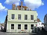 1 Potter Street |
| 15 Mill Wall Place | Sandwich | House | Early 17th century | 23 April 1976 | TR3320057908 51°16′21″N 1°20′31″E / 51.272573°N 1.34193°E |
1069612 | Upload Photo |
| 3 and 5 Vicarage Lane | Sandwich | Timber-framed house | Mid-13th-century arch | 19 May 1950 | TR3289458341 51°16′36″N 1°20′16″E / 51.276585°N 1.337833°E |
1121958 | Upload Photo |
| 17 Mill Wall Place | Sandwich | House | Early 19th century | 29 April 1970 | TR3320657892 51°16′21″N 1°20′31″E / 51.272427°N 1.342006°E |
1343757 | Upload Photo |
| 21 King Street | Sandwich | House | 18th century | 19 May 1950 | TR3315558053 51°16′26″N 1°20′29″E / 51.273893°N 1.341381°E |
1343765 | 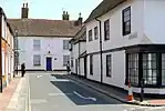 21 King Street |
| 27 Strand Street | Sandwich | Timber-framed house | 1526 | 19 May 1950 | TR3309158282 51°16′34″N 1°20′26″E / 51.275975°N 1.340614°E |
1069576 | Upload Photo |
| West Court & West Court Farmhouse | Shepherdswell with Coldred | Farmhouse | Early 14th century | 27 August 1952 | TR2479547948 51°11′12″N 1°12′55″E / 51.186531°N 1.215395°E |
1069986 | 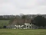 West Court & West Court Farmhouse |
| Church of St Nicholas | Sholden | Parish church | 13th century | 11 October 1963 | TR3592452170 51°13′12″N 1°22′38″E / 51.219947°N 1.377133°E |
1237584 | 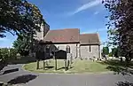 Church of St Nicholas |
| Church of St Peter | Westcliffe, St Margaret's at Cliffe | Parish church | 12th century | 22 August 1966 | TR3487544801 51°09′15″N 1°21′26″E / 51.154232°N 1.357324°E |
1070033 | 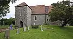 Church of St Peter |
| Transmitter Tower (tower 2), former Swingate Chain Home Radar Station | St Margaret's at Cliffe | Transmitter tower | 1936–38 | 13 July 2012 | TR3345642915 51°08′16″N 1°20′09″E / 51.137882°N 1.335848°E |
1405535 |  Transmitter Tower (tower 2), former Swingate Chain Home Radar Station |
| Wallets Court | Westcliffe, St Margaret's at Cliffe | House | 1627 | 27 August 1952 | TR3490444742 51°09′13″N 1°21′28″E / 51.15369°N 1.3577°E |
1084342 | 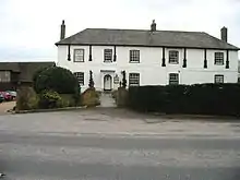 Wallets Court |
| Crixhall Court | Crixhall, Staple | House | Early 17th century | 13 October 1952 | TR2669555758 51°15′21″N 1°14′51″E / 51.255895°N 1.247472°E |
1354754 | Upload Photo |
| Stourmouth House | Stourmouth | House | Early 18th-century front | 13 October 1952 | TR2659162615 51°19′03″N 1°15′01″E / 51.317494°N 1.25033°E |
1281733 | Upload Photo |
| Church of St Peter and St Paul | Church Hill, Sutton | Parish church | 12th century | 11 October 1963 | TR3343249340 51°11′44″N 1°20′23″E / 51.195567°N 1.339672°E |
1247673 |  Church of St Peter and St Paul |
| Maydensole Farmhouse | Sutton | Farmhouse | 16th century | 11 October 1963 | TR3149047616 51°10′51″N 1°18′39″E / 51.18088°N 1.310816°E |
1237618 |  Maydensole Farmhouse |
| Church of St Peter and St Paul | Temple Ewell | Church | 12th century | 22 August 1966 | TR2861844221 51°09′06″N 1°16′04″E / 51.151557°N 1.267639°E |
1357572 |  Church of St Peter and St Paul |
| Church of All Saints | Waldershare, Tilmanstone | Church | 12th-century origins | 11 October 1963 | TR2970948277 51°11′15″N 1°17′09″E / 51.187532°N 1.285801°E |
1247812 | |
| Dane Court | Tilmanstone | House | 1724 | 13 October 1952 | TR2978151629 51°13′03″N 1°17′20″E / 51.217594°N 1.288974°E |
1247718 |  Dane Court |
| Malmains Farmhouse and Shareborne House and wall attached | Waldershare, Tilmanstone | Farmhouse | c.1800 | 13 October 1952 | TR2981649135 51°11′43″N 1°17′16″E / 51.195191°N 1.287878°E |
1263941 | Upload Photo |
| Church of St Mary the Blessed Virgin | Walmer | Church | 19th century | 1 June 1949 | TR3669650342 51°12′12″N 1°23′13″E / 51.20322°N 1.386962°E |
1251215 | |
| Church of St Peter | Whitfield | Church | 8th or 10th century | 23 April 1987 | TR3107145886 51°09′56″N 1°18′13″E / 51.165519°N 1.303721°E |
1068592 | 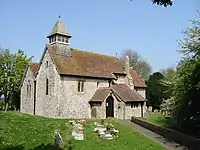 Church of St Peter |
| Delbridge House | Wingham | House | Early 18th century | 13 October 1952 | TR2413957461 51°16′20″N 1°12′43″E / 51.272193°N 1.211969°E |
1363339 | 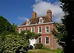 Delbridge House |
| Old Forge House | Wingham | Clergy house | 15th century | 13 October 1952 | TR2429057399 51°16′18″N 1°12′51″E / 51.271578°N 1.214091°E |
1203671 | 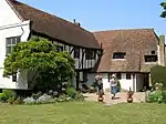 Old Forge House |
| The Dog Inn | Wingham | Public house | 15th century | 13 October 1952 | TR2426757397 51°16′18″N 1°12′50″E / 51.271569°N 1.213761°E |
1070097 | 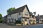 The Dog Inn |
| The Red Lion | Wingham | Continuous jetty house | Late 15th or 16th century | 13 October 1952 | TR2431557394 51°16′17″N 1°12′52″E / 51.271523°N 1.214446°E |
1363343 |  The Red Lion |
| The Vicarage | Wingham | Vicarage | Mid-18th century | 11 October 1963 | TR2426057347 51°16′16″N 1°12′49″E / 51.271122°N 1.213629°E |
1070101 | Upload Photo |
| Wingham Court and garden wall | Wingham | House | 15th century | 13 October 1952 | TR2417857411 51°16′18″N 1°12′45″E / 51.271729°N 1.212496°E |
1203692 |  Wingham Court and garden wall |
| 41 High Street | Wingham | House | Late 17th century | 13 October 1952 | TR2434857490 51°16′21″N 1°12′54″E / 51.272372°N 1.214978°E |
1070118 | 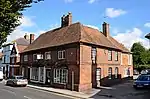 41 High Street |
| Church of St Mary the Virgin | Woodnesborough | Parish church | c.1200 | 11 October 1963 | TR3084156721 51°15′46″N 1°18′27″E / 51.262877°N 1.307405°E |
1281495 | 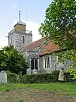 Church of St Mary the Virgin |
| Poulton Manor | Woodnesborough | House | Early 18th century | 13 October 1952 | TR2805657774 51°16′24″N 1°16′06″E / 51.273451°N 1.268227°E |
1203887 | 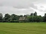 Poulton Manor |
| The Coach House, Street Farm | Woodnesborough | House | Early 18th century | 11 October 1963 | TR3112057157 51°16′00″N 1°18′42″E / 51.266678°N 1.311679°E |
1203901 | Upload Photo |
| Church of St Peter and St Paul | Worth | Parish church | 12th century | 11 October 1963 | TR3368456111 51°15′22″N 1°20′52″E / 51.256244°N 1.347683°E |
1263919 | 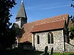 Church of St Peter and St Paul |
| Castle Hill House | Castle Hill Road, Dover | House | 1760 | 22 September 2014 | TR3222041565 51°07′35″N 1°19′02″E / 51.126459°N 1.317184°E |
1069524 | 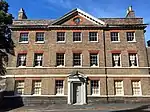 Castle Hill House |


See also
- Grade I listed buildings in Kent
- Grade II* listed buildings in Kent
- Grade II* listed buildings in Ashford (borough)
- Grade II* listed buildings in City of Canterbury
- Grade II* listed buildings in Dartford (borough)
- Grade II* listed buildings in Folkestone and Hythe
- Grade II* listed buildings in Gravesham
- Grade II* listed buildings in Maidstone (borough)
- Grade II* listed buildings in Medway
- Grade II* listed buildings in Sevenoaks (district)
- Grade II* listed buildings in Swale
- Grade II* listed buildings in Thanet
- Grade II* listed buildings in Tonbridge and Malling
- Grade II* listed buildings in Tunbridge Wells (borough)
Notes
- ↑ The date given is the date used by Historic England as significant for the initial building or that of an important part in the structure's description.
- ↑ Sometimes known as OSGB36, the grid reference is based on the British national grid reference system used by the Ordnance Survey.
- ↑ The "List Entry Number" is a unique number assigned to each listed building and scheduled monument by Historic England.
External links
This article is issued from Wikipedia. The text is licensed under Creative Commons - Attribution - Sharealike. Additional terms may apply for the media files.