| Woodnesborough | |
|---|---|
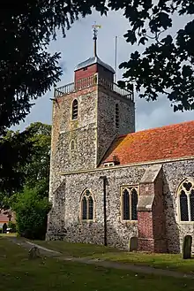
 St Mary the Blessed Virgin Church, Woodnesborough | |
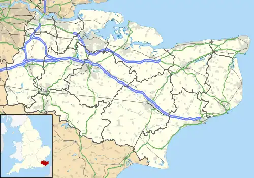
 Woodnesborough Location within Kent | |
| Population | 1,066 (2011 census)[1] |
| OS grid reference | TR310568 |
| District | |
| Shire county | |
| Region | |
| Country | England |
| Sovereign state | United Kingdom |
| Post town | Sandwich |
| Postcode district | CT13 |
| Dialling code | 01304 |
| Police | Kent |
| Fire | Kent |
| Ambulance | South East Coast |
| UK Parliament | |
Woodnesborough (/ˈwɪnzbrə/ WINZ-brə) is a village in the Dover District of Kent, England, 2 miles (3.2 km) west of Sandwich. The population taken at the 2011 census included Coombe as well as Marshborough, and totalled 1,066.[1] There is a Grade II* listed[2] Anglican church dedicated to St Mary the Virgin.
History
Its name is first attested in the Domesday Book of 1086 as Golles-Wanesberge, with forms like Wodnesbeorge being attested a little later, around 1100, and as 'Wodnesbergh' in 1484.[3] The name is believed to have meant Woden's hill/mound (Old English Wōdnes burh) after Anglo-Saxon god Woden (the English cognate of the Norse Odin, known in Proto-Germanic as Wodanaz); though some of the spellings also suggest *wænnes beorg ('hill of the mound'), from Old English wenn, wænn 'a tumour, blister, mound'. At the end of the eighteenth century there is a record of a burial mound beside the church, but the settlement also boasts a hill which could equally well have been described as a burh in Old English.[4]
The village was once served by East Kent Light Railway and can now be reached by bus services from Sandwich.
There was also a post office, which closed at the end of January 2008.
Listed buildings
St Mary the Blessed Virgin Church: the village's 13th-century Anglican church is Grade II* listed, with 14th-century alterations and a Victorian restoration in 1884 by Ewan Christian. The building is made of flint and rubble and boasts an unusual ogee cupola, a design feature shared by nearby Sandwich's St Peter's Church.[5]
Woodnesborough Village Hall: the building, a former school, dates from the 19th century.[6]
Sundial north of the Church of St Mary the Virgin: dating from 1738 with the inscription "Woodnesborough W IB RG 1738".[7]
Tomb Chest to Harrison family: situated about 2 metres W of Church of St Mary, and dating from 1777.[8]
Summerfield House: an early 18th-century house with red brick and plain tiled roof.[9]
Barn about 20m E of Summerfield House: a 17th-century barn now converted to a garage.[10]
References
- 1 2 "Civil parish population 2011". Neighbourhoocd Statistics. Office for National Statistics. Retrieved 12 September 2016.
- ↑ British Listed Buildings retrieved 20 July 2013
- ↑ Plea Rolls of the Court of Common Pleas; CP 40/890; http://aalt.law.uh.edu/AALT3/R3/CP40no890/bCP40no890dorses/IMG_1138.htm; 5th entry, where William Merlowe lived
- ↑ Victor Watts (ed.), The Cambridge Dictionary of English Place-Names Based on the Collections of the English Place-Name Society (Cambridge: Cambridge University Press, 2004), s.v. WOODNESBOROUGH.
- ↑ British Listed Buildings retrieved 20 July 2013
- ↑ Historic England. "Woodnesborough Village Hall (Grade II) (1070075)". National Heritage List for England. Retrieved 3 May 2020.
- ↑ Historic England. "Sundial 15m north of Church of St Mary the Virgin (Grade II) (1363310)". National Heritage List for England. Retrieved 3 May 2020.
- ↑ Historic England. "Tomb Chest to Harrison family about 2 metres W of Church of St Mary (Grade II) (1281504)". National Heritage List for England. Retrieved 3 May 2020.
- ↑ Historic England. "Summerfield House (Grade II) (1281466)". National Heritage List for England. Retrieved 3 May 2020.
- ↑ Historic England. "Barn about 20m E of Summerfield House (Grade II) (1203921)". National Heritage List for England. Retrieved 3 May 2020.
External links
![]() Media related to Woodnesborough at Wikimedia Commons
Media related to Woodnesborough at Wikimedia Commons
