
South Yorkshire shown in England
There are over 20,000 Grade II* listed buildings in England. This list includes those in South Yorkshire.
Barnsley
| Name | Location | Type | Completed [note 1] | Date designated | Grid ref.[note 2] Geo-coordinates |
Entry number [note 3] | Image |
|---|---|---|---|---|---|---|---|
| Grimethorpe Hall | Brierley, Barnsley | House | c. 1670 | 18 April 1985 | SE4103609639 53°34′54″N 1°22′54″W / 53.581744°N 1.381653°W |
1151202 | |
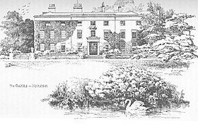
| Cannon Hall | Cawthorne, Barnsley | Country House | Late 17th century | 25 February 1952 | SE2721708332 53°34′15″N 1°35′26″W / 53.570893°N 1.590485°W |
1151805 | |
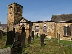
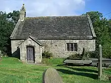
| Church of All Saints | Cawthorne, Barnsley | Church | 13th century | 18 March 1968 | SE2850307960 53°34′03″N 1°34′16″W / 53.567481°N 1.571101°W |
1191523 | 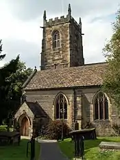 Church of All Saints |
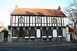
| Wool Greaves Farmhouse | Cawthorne, Barnsley | Farmhouse | 1672 | 18 March 1968 | SE2674806133 53°33′04″N 1°35′52″W / 53.551152°N 1.597755°W |
1192159 |  Upload Photo |
| Church of St Michael and All Angels and adjoining Stone Wall to West Side of Churchyard | Great Houghton, Barnsley | Church | 19th century | 18 April 1985 | SE4304106536 53°33′13″N 1°21′06″W / 53.553695°N 1.351798°W |
1151170 | .jpg.webp) Church of St Michael and All Angels and adjoining Stone Wall to West Side of Churchyard |
| Barn at Ingfield Farm immediately West of Ings Cottage | Ingbirchworth, Gunthwaite and Ingbirchworth, Barnsley | Cruck Barn | 16th century | 18 March 1968 | SE2233405641 53°32′49″N 1°39′52″W / 53.546935°N 1.66441°W |
1151108 | Upload Photo |
| Stable Range about 30m west of Gunthwaite Hall Barn | Gunthwaite, Gunthwaite and Ingbirchworth, Barnsley | Stable | 1699 | 25 February 1952 | SE2372806558 53°33′18″N 1°38′36″W / 53.555116°N 1.643303°W |
1151107 | Upload Photo |
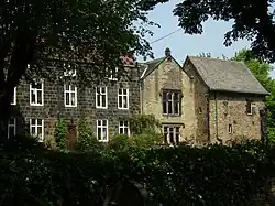
| Bullhouse Hall including the cottage to left (rear) | Millhouse, Penistone, Barnsley | House | 1655 | 27 April 1988 | SE2112202712 53°31′14″N 1°40′58″W / 53.520658°N 1.682898°W |
1151820 | Upload Photo |
| Cat Hill Farmhouse | Penistone, Barnsley | Farmhouse | 1634 | 23 June 1965 | SE2477605226 53°32′35″N 1°37′39″W / 53.543096°N 1.62759°W |
1191706 | Upload Photo |
| Summerhouse about 20 Metres north-east of No 1, Bullhouse | Millhouse, Penistone, Barnsley | Summerhouse | 1686 | 27 April 1988 | SE2115802758 53°31′16″N 1°40′56″W / 53.52107°N 1.682352°W |
1151824 | Upload Photo |
| Knabbe's Hall | Silkstone Common, Silkstone, Barnsley | Farmhouse | Third quarter of 17th century | 25 February 1952 | SE2883903821 53°31′49″N 1°33′59″W / 53.530261°N 1.566408°W |
1314749 | Upload Photo |
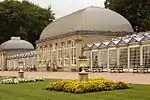
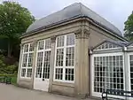
| Conservatory and linking Bridge at North West corner of Wentworth Castle | Wentworth Castle, Stainborough, Barnsley | Country House | 1840s | 25 February 1952 | SE3194203162 53°31′27″N 1°31′11″W / 53.524159°N 1.519665°W |
1191675 | 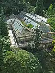 Conservatory and linking Bridge at North West corner of Wentworth Castle |
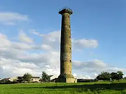
| Duke of Argyll's Monument | Wentworth Castle, Stainborough, Barnsley | Column | 1744 | 18 March 1968 | SE3224502420 53°31′03″N 1°30′55″W / 53.517472°N 1.515171°W |
1151064 |  Duke of Argyll's Monument |
| Gun Room | Wentworth Castle, Stainborough, Barnsley | Bath House | Late 18th century | 25 February 1952 | SE3194403224 53°31′29″N 1°31′11″W / 53.524716°N 1.519628°W |
1151066 | Upload Photo |
| Pillared Barn about 20m to south of Steeple Lodge | Wentworth Castle, Stainborough, Barnsley | Hay Barn | c. 1775 | 5 November 1973 | SE3186103465 53°31′37″N 1°31′15″W / 53.526888°N 1.520856°W |
1315049 | Upload Photo |
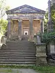
| Rotunda Temple | Wentworth Castle, Stainborough, Barnsley | Garden Temple | 1746 | 18 March 1968 | SE3278602722 53°31′13″N 1°30′25″W / 53.520153°N 1.506981°W |
1191615 |  Rotunda Temple |
| Stainborough Castle | Wentworth Castle, Stainborough, Barnsley | Folly | 1728-30 | 18 March 1968 | SE3158003047 53°31′23″N 1°31′30″W / 53.523147°N 1.525137°W |
1151069 |  Stainborough Castle |
| Statue of the First Earl of Strafford situated at North End of East Front of Wentworth Castle | Wentworth Castle, Stainborough, Barnsley | Statue | 1744 | 4 December 1986 | SE3199003220 53°31′29″N 1°31′08″W / 53.524678°N 1.518935°W |
1191709 | Upload Photo |
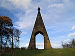
| Queen Anne's Obelisk | Wentworth Castle, Stainborough, Barnsley | Monument | 1734 | 11 November 1966 | SE3318702917 53°31′19″N 1°30′03″W / 53.521880°N 1.5009123°W |
1192441 | .jpg.webp) Queen Anne's Obelisk |
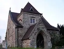
| Church of St Peter | Tankersley, Barnsley | Church | 1901 | 25 April 1969 | SK3495099586 53°29′31″N 1°28′29″W / 53.491827°N 1.474692°W |
1286900 |  Church of St Peter |
| Huthwaite Hall | Thurgoland, Barnsley | House | 1748 | 27 April 1988 | SE2836900454 53°30′00″N 1°34′26″W / 53.500024°N 1.573802°W |
1286726 | 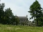 Huthwaite Hall |
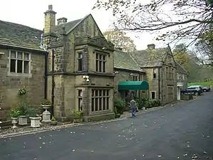
| Wortley Hall with attached South-front Terrace and Steps including attached Retaining Wall and Steps to Wing set back on left | Wortley, Barnsley | Country House | 1742-46 | 25 April 1969 | SK3124199495 53°29′28″N 1°31′50″W / 53.491242°N 1.530602°W |
1192585 | 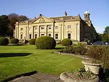 Wortley Hall with attached South-front Terrace and Steps including attached Retaining Wall and Steps to Wing set back on left |
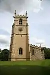
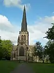
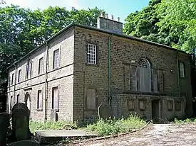
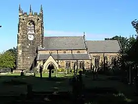
| Church of St Mary | Barnsley, Barnsley | Church | c. 1400 | 13 January 1986 | SE3435606656 53°33′19″N 1°28′58″W / 53.555412°N 1.482872°W |
1315008 | 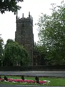 Church of St Mary |
| Church of St Peter Including Attached Wall and Gateway to South West | Barnsley, Barnsley | Gate | 1893-1910 | 13 January 1986 | SE3510405883 53°32′54″N 1°28′18″W / 53.548415°N 1.471668°W |
1314984 | Upload Photo |
| Darley Cliffe Hall including attached Front Garden Wall and Dwellings known as Tudor House and Dower Cottage | Barnsley | House | 17th century | 11 November 1966 | SE3554704510 53°32′10″N 1°27′54″W / 53.536044°N 1.465138°W |
1151042 | Upload Photo |
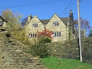
| Houndhill | Barnsley | House | 1606 | 11 November 1966 | SE3372604141 53°31′58″N 1°29′34″W / 53.532848°N 1.492652°W |
1151039 | Upload Photo |
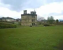
| Locke Park Tower | Barnsley, Barnsley | Tower | 1875-1877 | 13 July 1976 | SE3425005092 53°32′29″N 1°29′05″W / 53.541361°N 1.484643°W |
1315014 |  Locke Park Tower |
| Swaithe House | Swaithe, Barnsley | Farmhouse | 17th century | 11 November 1966 | SE3723004098 53°31′56″N 1°26′23″W / 53.532225°N 1.439795°W |
1286701 | Upload Photo |
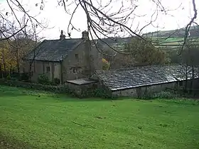
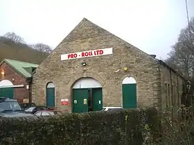
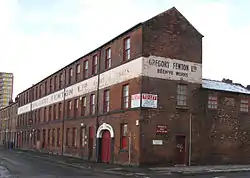
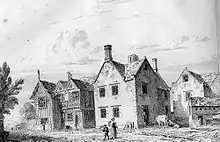
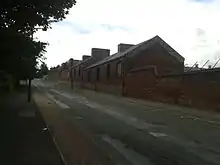
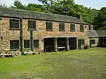
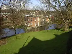
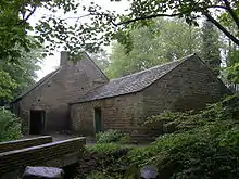
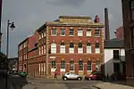
| Worsbrough Corn Mill | Barnsley | Corn Mill | Early 17th century | 11 November 1966 | SE3494503326 53°31′32″N 1°28′28″W / 53.525443°N 1.474352°W |
1151044 |
.jpg.webp)
.jpg.webp)

Doncaster
| Name | Location | Type | Completed [note 1] | Date designated | Grid ref.[note 2] Geo-coordinates |
Entry number [note 3] | Image |
|---|---|---|---|---|---|---|---|
| Church of St John | Adwick upon Dearne, Doncaster | Church | 12th century | 5 June 1968 | SE4702401495 53°30′29″N 1°17′33″W / 53.508047°N 1.292437°W |
1151670 | .jpg.webp) Church of St John |
| Church of St Helena | Austerfield, Doncaster | Church | 11th century | 5 June 1968 | SK6616694691 53°26′41″N 1°00′19″W / 53.444843°N 1.005284°W |
1151575 | 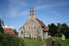 Church of St Helena |
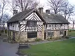
| Barnburgh Hall Dovecote | Barnburgh, Doncaster | Dovecote | Late C16-Early 17th century | 5 June 1968 | SE4867703332 53°31′28″N 1°16′02″W / 53.524407°N 1.267231°W |
1314757 | 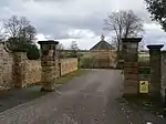 Barnburgh Hall Dovecote |
| Church of St Oswald | Kirk Sandall, Barnby Dun with Kirk Sandall, Doncaster | Church | 12th century | 5 June 1968 | SE6092808130 53°33′59″N 1°04′54″W / 53.566253°N 1.081529°W |
1286919 | |
| Bawtry Hall | Bawtry, Doncaster | House | 1785 | 11 January 1988 | SK6506692876 53°25′43″N 1°01′20″W / 53.428668°N 1.022218°W |
1151550 | |
| Church of St James | Braithwell, Doncaster | Sundial | 1828 | 5 June 1968 | SK5299294697 53°26′47″N 1°12′13″W / 53.446383°N 1.203605°W |
1286514 | 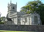 Church of St James |
| Church of St Michael and All Angels | Brodsworth, Doncaster | Church | 11th century | 5 June 1968 | SE5067307230 53°33′33″N 1°14′11″W / 53.559253°N 1.236496°W |
1191555 | .jpg.webp) Church of St Michael and All Angels |
| St Anne's Rest Home | Burghwallis, Doncaster | House | Early 16th century | 23 March 1988 | SE5362011988 53°36′06″N 1°11′28″W / 53.601722°N 1.191197°W |
1192073 | Upload Photo |
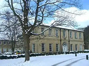
| Cantley Hall and Outbuildings | Cantley, Doncaster | Country House | 1785 | 5 June 1968 | SE6249102139 53°30′44″N 1°03′33″W / 53.512228°N 1.059127°W |
1191866 | .jpg.webp) Cantley Hall and Outbuildings |
| Church of All Saints | Clayton with Frickley, Doncaster | Church | 12th century | 5 June 1968 | SE4684907882 53°33′56″N 1°17′39″W / 53.565467°N 1.294122°W |
1151647 | 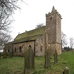 Church of All Saints |
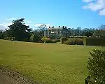
| Hickleton Hall with attached Quadrant Walls and Walls extended to enclose Entrance Front Garden with associated Gate Piers and Statues | Hickleton, Doncaster | Country House | 1745-1748 | 27 May 1953 | SE4822605154 53°32′27″N 1°16′26″W / 53.540824°N 1.273753°W |
1286810 | 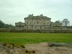 Hickleton Hall with attached Quadrant Walls and Walls extended to enclose Entrance Front Garden with associated Gate Piers and Statues |
| Stable to Hickleton Hall including the Stable Cottage and attached Walls and Gatepiers | Hickleton Hall, Hickleton, Doncaster | House | Post Mid 18th century | 11 April 1986 | SE4820805244 53°32′30″N 1°16′26″W / 53.541635°N 1.274011°W |
1151659 | Upload Photo |
| The Brewhouse | Hickleton Hall, Hickleton, Doncaster | Brewhouse | Mid 18th century | 11 April 1986 | SE4820305212 53°32′29″N 1°16′27″W / 53.541348°N 1.274091°W |
1286781 | Upload Photo |
| Church of St James | High Melton, Doncaster | Church | 12th century | 5 June 1968 | SE5091701811 53°30′38″N 1°14′01″W / 53.510526°N 1.233693°W |
1192208 | |
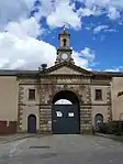
| Hooton Pagnell Hall including Archway Flat. Nos 1 and 2, Hall Cottages, Ground Floor Flat, First Floor Flat and Pump End | Hooton Pagnell Hall, Hooton Pagnell, Doncaster | House | 18th century | 27 May 1953 | SE4856907874 53°33′55″N 1°16′05″W / 53.565239°N 1.268156°W |
1192355 | .jpg.webp) Hooton Pagnell Hall including Archway Flat. Nos 1 and 2, Hall Cottages, Ground Floor Flat, First Floor Flat and Pump End |
| Church of St Mary | Kirk Bramwith, Doncaster | Church | 12th century | 29 September 1987 | SE6199611722 53°35′54″N 1°03′53″W / 53.59841°N 1.064693°W |
1286522 | 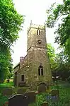 Church of St Mary |
| Church of St Katharine | Loversall, Doncaster | Church | c. 1300 | 5 June 1968 | SK5761398733 53°28′56″N 1°08′00″W / 53.482173°N 1.1333°W |
1193085 | 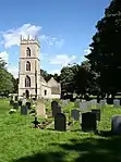 Church of St Katharine |
| Tomb Chest about 3m to South of South Chapel to Church of St Katharine | Loversall, Doncaster | Chest Tomb | Early 14th century | 26 November 1987 | SK5761898718 53°28′55″N 1°08′00″W / 53.482037°N 1.133227°W |
1314861 | 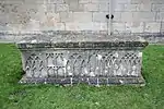 Tomb Chest about 3m to South of South Chapel to Church of St Katharine |
| Owston Hall, Flats 1 to 5 and including the Old Hall | Owston Village, Owston, Doncaster | Apartment | 1988 | 5 June 1968 | SE5500111090 53°35′37″N 1°10′14″W / 53.593509°N 1.170488°W |
1286676 | 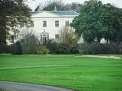 Owston Hall, Flats 1 to 5 and including the Old Hall |
| Church of St Michael | Rossington, Doncaster | Church | 12th century | 5 June 1968 | SK6250898396 53°28′43″N 1°03′35″W / 53.478587°N 1.059615°W |
1151519 | 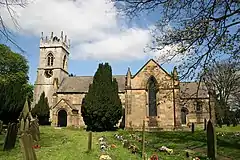 Church of St Michael |
| Church of St Winifred | Stainton, Doncaster | Church | 12th century | 5 June 1968 | SK5552093633 53°26′12″N 1°09′57″W / 53.436561°N 1.165734°W |
1286289 |  Church of St Winifred |
| Remains of Chapel at Manor House Farm | Thorpe in Balne, Doncaster | Chapel | 12th century | 5 June 1968 | SE5990511084 53°35′35″N 1°05′47″W / 53.592919°N 1.096407°W |
1286641 | Upload Photo |
| Lindrick House | Tickhill, Doncaster | House | Early 18th century | 22 January 1981 | SK5904792660 53°25′39″N 1°06′46″W / 53.427434°N 1.112832°W |
1191433 | 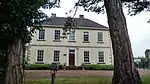 Lindrick House |
| St Leonard's Hospital | Tickhill, Doncaster | House | 1470 | 27 December 1962 | SK5924693374 53°26′02″N 1°06′35″W / 53.433828°N 1.109703°W |
1191574 | |
| The Friary and Friary Close | Tickhill, Doncaster | House | 1983 | 27 December 1962 | SK5860492755 53°25′42″N 1°07′10″W / 53.428337°N 1.11948°W |
1286862 | Upload Photo |
| Tickhill Castle House | Tickhill, Doncaster | House | 17th century | 22 January 1981 | SK5929392902 53°25′46″N 1°06′33″W / 53.429581°N 1.109085°W |
1151747 | 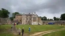 Tickhill Castle House |
| East Lodge and attached Forecourt Wall | Wadworth, Doncaster | Gate Lodge | c. 1750 | 5 June 1968 | SK5672797193 53°28′06″N 1°08′49″W / 53.468428°N 1.146927°W |
1193428 | Upload Photo |
| West Lodge and attached Forecourt Wall | Wadworth, Doncaster | Gate Lodge | c. 1750 | 5 June 1968 | SK5669297190 53°28′06″N 1°08′51″W / 53.468405°N 1.147455°W |
1151506 | Upload Photo |
| Warmsworth Hall | Warmsworth, Doncaster | House | 1668 | 5 June 1968 | SE5471400608 53°29′58″N 1°10′36″W / 53.499333°N 1.176654°W |
1193489 |  Warmsworth Hall |
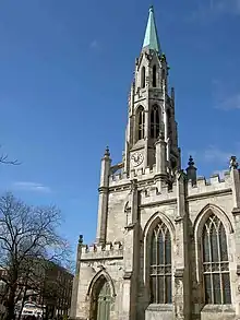
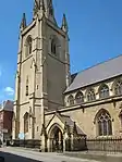
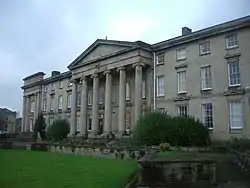
| Christ Church | Doncaster | Church | 1827-9 | 12 June 1950 | SE5797703309 53°31′24″N 1°07′37″W / 53.523259°N 1.126971°W |
1286309 | |
| Church of St Laurence | Adwick-le-Street, Doncaster | Church | 12th century | 19 October 1962 | SE5409808601 53°34′16″N 1°11′04″W / 53.571233°N 1.18456°W |
1151473 | 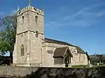 Church of St Laurence |
| Church of St Wilfrid | Cantley, Doncaster | Tower | 15th century | 5 September 1988 | SE6185001439 53°30′22″N 1°04′08″W / 53.506012°N 1.068929°W |
1151446 | |
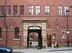
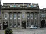
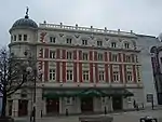
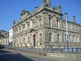
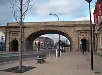
| The Market Hall, Corn Exchange and Fish Market | Doncaster | Corn Exchange | 1870-3 | 12 June 1950 | SE5759303444 53°31′28″N 1°07′58″W / 53.524514°N 1.132738°W |
1192688 |
.jpg.webp)

Rotherham
| Name | Location | Type | Completed [note 1] | Date designated | Grid ref.[note 2] Geo-coordinates |
Entry number [note 3] | Image |
|---|---|---|---|---|---|---|---|
| Aughton Court | Aston, Aston cum Aughton, Rotherham | Country House | c. 1772 | 29 March 1968 | SK4690485181 53°21′41″N 1°17′48″W / 53.36143°N 1.296671°W |
1314660 | |
| Hellaby Hall | Bramley, Rotherham | House | c. 1690 | 1 April 1987 | SK5057692271 53°25′29″N 1°14′25″W / 53.424816°N 1.240366°W |
1192650 |  Hellaby Hall |
| Hoober Stand | Brampton Bierlow, Rotherham | Tower | 1747-9 | 29 April 1952 | SK4074798545 53°28′55″N 1°23′15″W / 53.482055°N 1.387458°W |
1132812 | |
| Needle's Eye | Brampton Bierlow, Rotherham | Carriageway | Mid-Late 18th century | 29 March 1968 | SK3962298821 53°29′05″N 1°24′16″W / 53.484622°N 1.404375°W |
1314588 | |
| Rainborough Lodges and Gates | Brampton Bierlow, Rotherham | Gate Lodge | 1798-1804 | 29 March 1968 | SE4075700616 53°30′02″N 1°23′13″W / 53.500668°N 1.387039°W |
1314591 |  Rainborough Lodges and Gates |
| Dinnington Hall | Dinnington St. John's, Rotherham | House | Early to mid 18th century | 29 July 1966 | SK5248885686 53°21′56″N 1°12′46″W / 53.365446°N 1.212689°W |
1314652 |  Dinnington Hall |
| 4, Walseker Lane | Woodall, Harthill with Woodall, Rotherham | Farmhouse | Late Medieval | 15 October 1986 | SK4828780763 53°19′18″N 1°16′36″W / 53.321598°N 1.276564°W |
1132671 | Upload Photo |
| Church of St John the Baptist | Hooton Roberts, Rotherham | Church | 12th century | 29 March 1968 | SK4840397066 53°28′05″N 1°16′20″W / 53.468116°N 1.272328°W |
1286668 |  Church of St John the Baptist |
| Slade Hooton Hall | Slade Hooton, Laughton-en-le-Morthen, Rotherham | Country House | 1698 | 29 March 1968 | SK5242089240 53°23′51″N 1°12′47″W / 53.397395°N 1.213122°W |
1151845 | .jpg.webp) Slade Hooton Hall |
| Stable and Remains of attached Barn immediately to South West of Slade Hooton Hall | Slade Hooton, Laughton-en-le-Morthen, Rotherham | Barn | 1705 | 29 March 1968 | SK5240889217 53°23′50″N 1°12′48″W / 53.397189°N 1.213306°W |
1193434 | Upload Photo |
| Wall enclosing Front Garden to Slade Hooton Hall including attached Gatepiers and Gateway | Slade Hooton, Laughton-en-le-Morthen, Rotherham | Gate | c. 1700 | 29 March 1968 | SK5239789267 53°23′52″N 1°12′48″W / 53.39764°N 1.213463°W |
1151846 | Upload Photo |
| Church of St Peter | Letwell, Rotherham | Church | 15th century | 29 July 1966 | SK5594787052 53°22′39″N 1°09′38″W / 53.377369°N 1.160473°W |
1132679 | |
| Langold Farmhouse | Letwell, Rotherham | Farmhouse | Mid C18, pre 1768 | 29 May 1966 | SK5703886529 53°22′21″N 1°08′39″W / 53.372552°N 1.144169°W |
1132672 | Upload Photo |
| Old Stable and Coachhouse Buildings at Langold | Letwell, Rotherham | House | 1986 | 29 May 1966 | SK5703986529 53°22′21″N 1°08′39″W / 53.372552°N 1.144154°W |
1314640 | Upload Photo |
| Church of Saint Bartholomew | Maltby, Rotherham | Church | 11th century | 13 November 1959 | SK5276791883 53°25′16″N 1°12′27″W / 53.421115°N 1.207463°W |
1314662 | 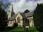 Church of Saint Bartholomew |
| Malpas Hill Gateway | Sandbeck Park, Maltby, Rotherham | Gate | c. 1760 | 13 November 1959 | SK5885990280 53°24′22″N 1°06′58″W / 53.406065°N 1.116104°W |
1314689 | 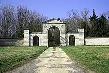 Malpas Hill Gateway |
| Sandbeck Park Stables | Sandbeck Park, Maltby, Rotherham | House | c. 1760 | 13 November 1959 | SK5683690337 53°24′24″N 1°08′47″W / 53.406798°N 1.146521°W |
1151900 | Upload Photo |
| Church of St James | Ravenfield, Rotherham | Church | 18th century | 29 March 1968 | SK4858795452 53°27′13″N 1°16′11″W / 53.453593°N 1.269805°W |
1151867 | 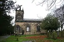 Church of St James |
| Gatehouse to Thorpe Salvin Hall | Thorpe Salvin, Rotherham | Gatehouse | Mid-late 16th century | 29 July 1966 | SK5212681243 53°19′32″N 1°13′08″W / 53.325548°N 1.218858°W |
1314668 |  Gatehouse to Thorpe Salvin Hall |
| Ruins of Thorpe Salvin Hall | Thorpe Salvin, Rotherham | Country House | Mid to late C16, pre 1582 | 29 July 1966 | SK5213981266 53°19′33″N 1°13′07″W / 53.325754°N 1.218659°W |
1286372 |  Ruins of Thorpe Salvin Hall |
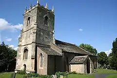
| Church of St Leonard | Thrybergh, Rotherham | Church | 11th century | 29 March 1968 | SK4668795489 53°27′15″N 1°17′54″W / 53.454097°N 1.298409°W |
1132783 |  Church of St Leonard |
| Thurcroft Hall | Brookhouse, Thurcroft, Rotherham | Country House | 1699 | 29 March 1968 | SK5095889213 53°23′50″N 1°14′06″W / 53.397295°N 1.235111°W |
1314692 |  Thurcroft Hall |
| Church of St Peter and St Paul | Todwick, Rotherham | Church | 11th century | 29 July 1986 | SK4974684126 53°21′06″N 1°15′15″W / 53.351689°N 1.254136°W |
1151903 | 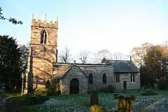 Church of St Peter and St Paul |
| Church of St John the Baptist | Wales, Rotherham | Church | Early 12th century | 29 May 1966 | SK4775782683 53°20′20″N 1°17′03″W / 53.338902°N 1.284231°W |
1286360 | 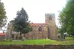 Church of St John the Baptist |
| Camellia House | Wentworth Woodhouse, Wentworth, Rotherham | Camellia House | Mid 18th century | 29 March 1968 | SK3909697685 53°28′28″N 1°24′45″W / 53.47445°N 1.412442°W |
1286162 |  Camellia House |
| Church of the Holy Trinity | Wentworth, Rotherham | Church | 1872-76 | 29 March 1968 | SK3838798141 53°28′43″N 1°25′23″W / 53.478601°N 1.423068°W |
1192788 | |
| Doric Temple | Wentworth Park, Wentworth, Rotherham | Park | c. 1745 | 29 April 1952 | SK3993097174 53°28′11″N 1°24′00″W / 53.469795°N 1.399943°W |
1193160 |  Doric Temple |
| Gateway with attached Plinth Wall and Ironwork Screen forming South Side of South Court at Wentworth Woodhouse | Wentworth Woodhouse, Wentworth, Rotherham | Gate | c. 1630 | 21 August 1985 | SK3957797633 53°28′26″N 1°24′19″W / 53.473947°N 1.405202°W |
1193422 |  Gateway with attached Plinth Wall and Ironwork Screen forming South Side of South Court at Wentworth Woodhouse |
| Holy Trinity Wentworth (old) Church | Wentworth, Rotherham | Church | C14-C15 | 29 March 1968 | SK3838198283 53°28′48″N 1°25′23″W / 53.479878°N 1.423141°W |
1314580 | |
| Ionic Temple at West End of South Terrace | Wentworth Woodhouse, Wentworth, Rotherham | Temple | Possibly as early as 1735 | 21 August 1985 | SK3912497554 53°28′24″N 1°24′43″W / 53.473271°N 1.412037°W |
1132730 | .jpg.webp) Ionic Temple at West End of South Terrace |
| Church of St Mary Magdalene | Whiston, Rotherham | Church | 12th century | 29 March 1968 | SK4510590025 53°24′18″N 1°19′23″W / 53.405124°N 1.323011°W |
1192880 | 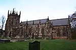 Church of St Mary Magdalene |
| Morthen Hall | Whiston, Rotherham | Country House | Early 18th century | 29 March 1968 | SK4788689476 53°24′00″N 1°16′53″W / 53.399946°N 1.281267°W |
1192970 | .jpg.webp) Morthen Hall |
| Whiston Hall Barn | Whiston, Rotherham | Barn | 16th century | 19 February 1986 | SK4473490053 53°24′19″N 1°19′43″W / 53.405407°N 1.328587°W |
1132687 | 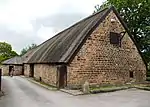 Whiston Hall Barn |
| Clifton House | Rotherham | House | 1783 | 19 October 1951 | SK4348892734 53°25′47″N 1°20′49″W / 53.429608°N 1.346959°W |
1286766 | |
| Keppel's Column | Thorpe Common, Rotherham | Column | 1773-80 | 19 February 1986 | SK3894194731 53°26′52″N 1°24′55″W / 53.447911°N 1.415142°W |
1314632 | |
| Moorgate Hall and attached Outbuilding | Rotherham | House | 17th century | 19 October 1951 | SK4313192071 53°25′25″N 1°21′09″W / 53.423678°N 1.352422°W |
1132715 | 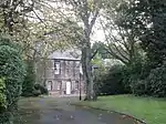 Moorgate Hall and attached Outbuilding |
| Rockingham Kiln | Rotherham | Pottery Kiln | Early 19th century | 11 December 1953 | SK4405498814 53°29′03″N 1°20′15″W / 53.484207°N 1.337591°W |
1314614 | |
| St Marys Rectory | Rotherham | Vicarage | 1752 | 8 October 1962 | SK4363495926 53°27′30″N 1°20′40″W / 53.458285°N 1.34432°W |
1314613 | Upload Photo |
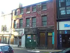
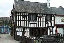
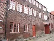
| 25 and 27 High Street | Rotherham | Inn | 15th century | 23 November 1973 | SK4287792796 53°25′49″N 1°21′22″W / 53.430215°N 1.356146°W |
1132712 | 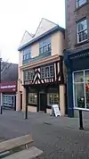 25 and 27 High Street |


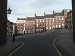
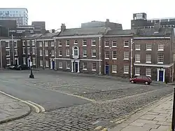
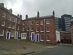
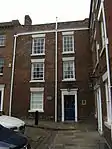
Sheffield


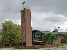
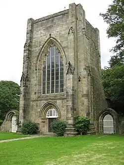
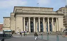
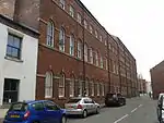


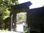

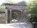
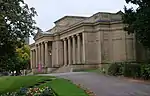


.JPG.webp)


_Sheffield_-_geograph.org.uk_-_1473087.jpg.webp)
.jpg.webp)
Notes
- 1 2 3 4 The date given is the date used by Historic England as significant for the initial building or that of an important part in the structure's description.
- 1 2 3 4 Sometimes known as OSGB36, the grid reference is based on the British national grid reference system used by the Ordnance Survey.
- 1 2 3 4 The "List Entry Number" is a unique number assigned to each listed building and scheduled monument by Historic England.
External links
![]() Media related to Grade II* listed buildings in South Yorkshire at Wikimedia Commons
Media related to Grade II* listed buildings in South Yorkshire at Wikimedia Commons
| Metropolitan districts | |
|---|---|
| Major settlements (cities in italics) |
|
| Rivers | |
| Topics |
|
This article is issued from Wikipedia. The text is licensed under Creative Commons - Attribution - Sharealike. Additional terms may apply for the media files.