Yellowstone County, Montana
Yellowstone County is the most populous county in the U.S. state of Montana. As of the 2020 United States Census, 164,731 people lived there.[1] Its county seat is Billings.[2]
Yellowstone County | |
|---|---|
.jpg.webp) Postcard. Pompeys Pillar National Monument. | |
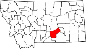 Location within the U.S. state of Montana | |
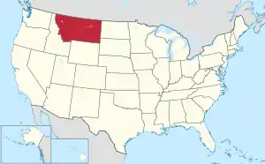 Montana's location within the U.S. | |
| Coordinates: 45°56′N 108°16′W | |
| Country | |
| State | |
| Founded | February 26, 1883 |
| Named for | Yellowstone River |
| Seat | Billings |
| Largest city | Billings |
| Area | |
| • Total | 2,649 sq mi (6,860 km2) |
| • Land | 2,633 sq mi (6,820 km2) |
| • Water | 16 sq mi (40 km2) 0.6% |
| Population (2020) | |
| • Total | 164,731 |
| • Density | 62/sq mi (24/km2) |
| Time zone | UTC−7 (Mountain) |
| • Summer (DST) | UTC−6 (MDT) |
| Congressional district | 2nd |
| Website | www |
| |
References
- "QuickFacts: Yellowstone County, Montana". United States Census Bureau. Retrieved January 5, 2024.
- "Find a County". National Association of Counties. Retrieved June 7, 2011.
Municipalities and communities of Yellowstone County, Montana, United States | ||
|---|---|---|
| Cities | Yellowstone County map | |
| Town |
| |
| CDPs |
| |
| Other communities |
| |
| Indian reservation |
| |
| Ghost towns |
| |
| Footnotes | ‡This populated place also has portions in an adjacent county or counties | |
Helena (capital) | ||
| Topics | ||
| Society |
| |
| Regions |
| |
| Largest cities | ||
| Counties |
| |
This article is issued from Wikipedia. The text is licensed under Creative Commons - Attribution - Sharealike. Additional terms may apply for the media files.