Meagher County, Montana
Meagher County (pronounced Marr) is a county in the U.S. state of Montana. As of 2020, there were 1,927 people.[1] Its county seat is White Sulphur Springs[2]. The center of population of Montana is also in Meagher County at 46.813302°N 111.209708°W[3]
Meagher County | |
|---|---|
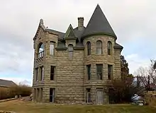 The Castle of White Sulphur Springs | |
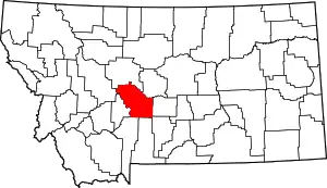 Location within the U.S. state of Montana | |
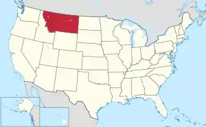 Montana's location within the U.S. | |
| Coordinates: 46°48′47″N 111°12′36″W | |
| Country | |
| State | |
| Founded | November 16, 1867 |
| Named for | Thomas Francis Meagher |
| Seat | White Sulphur Springs |
| Largest city | White Sulphur Springs |
| Area | |
| • Total | 2,395 sq mi (6,200 km2) |
| • Land | 2,392 sq mi (6,200 km2) |
| • Water | 2.8 sq mi (7 km2) 0.1% |
| Population (2020) | |
| • Total | 1,927 |
| • Density | 0.80/sq mi (0.31/km2) |
| Time zone | UTC−7 (Mountain) |
| • Summer (DST) | UTC−6 (MDT) |
| Congressional district | 2nd |
| Website | www |
| |
Meagher County was named for Thomas Francis Meagher, territorial governor of Montana.
The first county seat was Diamond City, the main city of the Confederate Gulch mining district. This entire area is no longer part of Meagher County. It is now in neighboring Broadwater County.
National protected areas
- Gallatin National Forest (part)
- Helena National Forest (part)
- Lewis and Clark National Forest (part)
Border Counties
- Cascade County, Montana - north
- Judith Basin County, Montana - northeast
- Wheatland County, Montana - east
- Sweet Grass County, Montana - southeast
- Park County, Montana - south
- Gallatin County, Montana - south
- Broadwater County, Montana - west
- Lewis and Clark County, Montana - northwest
References
- "QuickFacts: Meagher County, Montana". United States Census Bureau. Retrieved January 5, 2024.
- "Find a County". National Association of Counties. Retrieved 2008-01-31.
- "Population and Population Centers by State:2000" (txt). United States Census Bureau. Retrieved 2007-02-23.
Helena (capital) | ||
| Topics | ||
| Society |
| |
| Regions |
| |
| Largest cities | ||
| Counties |
| |
This article is issued from Wikipedia. The text is licensed under Creative Commons - Attribution - Sharealike. Additional terms may apply for the media files.