Sheridan County, Montana
Sheridan County is a county found in the U.S. state of Montana. As of the 2020 United States Census, there were 3,539 people.[1] Its county seat is Plentywood.[2] Its northern boundary is the Canada–United States border south of Saskatchewan.
Sheridan County | |
|---|---|
 Sheridan County Courthouse in Plentywood | |
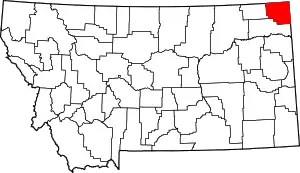 Location within the U.S. state of Montana | |
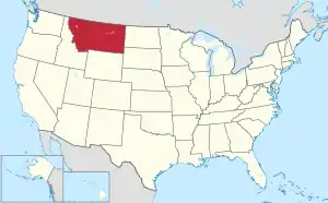 Montana's location within the U.S. | |
| Coordinates: 48°44′N 104°30′W | |
| Country | |
| State | |
| Founded | March 11, 1913 |
| Named for | Philip Sheridan |
| Seat | Plentywood |
| Largest city | Plentywood |
| Area | |
| • Total | 1,706 sq mi (4,420 km2) |
| • Land | 1,677 sq mi (4,340 km2) |
| • Water | 29 sq mi (80 km2) 1.7% |
| Population (2020) | |
| • Total | 3,539 |
| • Density | 2.1/sq mi (0.80/km2) |
| Time zone | UTC−7 (Mountain) |
| • Summer (DST) | UTC−6 (MDT) |
| Congressional district | 2nd |
| Website | www |
| |
History
The county was founded in 1913 and named for American Civil War General Philip Sheridan.[3]
Geography
According to the United States Census Bureau, the county has a total area of 1,706 square miles (4,420 km2), of which 1,677 square miles (4,340 km2) is land and 29 square miles (75 km2) (1.7%) is water.[4]
Bordering counties and rural municipalities
- Daniels County - west
- Roosevelt County - south
- Williams County, North Dakota - east
- Divide County, North Dakota - east
- Happy Valley No. 10, Saskatchewan - north
- Surprise Valley No. 9, Saskatchewan - north
- Lake Alma No. 8, Saskatchewan - north
Communities
City
- Plentywood (county seat)
Towns
- Medicine Lake
- Outlook
- Westby
Census-designated places
- Antelope
- Reserve
Unincorporated communities
- Coalridge
- Comertown
- Dagmar
- Daleview
- Homestead
- Raymond
- Redstone
- Rock Crossing
Ghost towns
- Dooley
References
- "QuickFacts: Sheridan County, Montana". United States Census Bureau. Retrieved January 5, 2024.
- "Find a County". National Association of Counties. Retrieved June 7, 2011.
- "Montana Place Names Companion". Montana Place Names From Alzada to Zortman. Montana Historical Society Research Center. Retrieved 9 May 2011.
- "2010 Census Gazetteer Files". US Census Bureau. August 22, 2012. Archived from the original on December 5, 2014. Retrieved November 30, 2014.
Other websites
Wikimedia Commons has media related to Sheridan County, Montana.
- Sheridan County official website Archived 2008-05-10 at the Wayback Machine
Places next to Sheridan County, Montana | ||||||||||
|---|---|---|---|---|---|---|---|---|---|---|
| ||||||||||
Helena (capital) | ||
| Topics | ||
| Society |
| |
| Regions |
| |
| Largest cities | ||
| Counties |
| |
This article is issued from Wikipedia. The text is licensed under Creative Commons - Attribution - Sharealike. Additional terms may apply for the media files.