Tokyo
Tokyo (Japanese: 東京, romanized: Tōkyō, lit. 'Eastern Capital') is the capital and largest city of Japan. It is on the island of Honshu in the region of Kanto. Tokyo is the center of the Japanese government. The Imperial Palace is in Tokyo, it's not actually public for tourist. Tokyo is the center of business, trade, and industry of Japan. The city is the center of the largest metropolitan area in the world. It faces Tokyo Bay.
Tokyo
東京都 | |
|---|---|
| Tokyo Metropolis | |
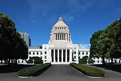
Clockwise from top: Nishi-Shinjuku skyscrapers and Mount Fuji, Rainbow Bridge, National Diet Building, Tokyo Station in Marunouchi, Shibuya Crossing, Tokyo Skytree | |
 Flag  Symbol | |
| Anthem: "Tokyo Metropolitan Song" (東京都歌, Tōkyō-to Ka) | |
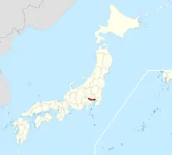
 Location within Japan | |
| Coordinates: 35°41′23″N 139°41′32″E | |
| Country | Japan |
| Region | Kantō |
| Island | Honshu |
| Capital | Tokyo[1] |
| Divisions | 23 special wards, 26 cities, 1 district, and 4 subprefectures |
| Government | |
| • Body | Tokyo Metropolitan Government |
| • Governor | Yuriko Koike (TF) |
| • Representatives | 42 |
| • Councillors | 11 |
| Area | |
| • Total | 2,194.07 km2 (847.14 sq mi) |
| • Rank | 45th in Japan |
| Highest elevation | 2,017 m (6,617 ft) |
| Lowest elevation | 0 m (0 ft) |
| Population (2021)[4] | |
| • Total | 13,960,236 |
| • Rank | 1st in Japan |
| • Density | 6,363/km2 (16,480/sq mi) |
| • Metro | 37,468,000 (2018, Greater Tokyo Area) 1st in the world |
| Demonym | Tokyoite |
| GDP (2018)[6] | |
| • Total, nominal | ¥106.6 trillion (~US$1.0 trillion) |
| • Per capita | ¥7.7 million (~US$70,000) |
| Time zone | UTC+09:00 (Japan Standard Time) |
| ISO 3166-2 | JP-13 |
| Flower | Yoshino cherry |
| Tree | Ginkgo |
| Bird | Black-headed gull |
| Website | www |
| Tokyo | |||||||
Tōkyō in kanji | |||||||
| Japanese name | |||||||
|---|---|---|---|---|---|---|---|
| Kanji | 東京 | ||||||
| Hiragana | とうきょう | ||||||
| Katakana | トウキョウ | ||||||
| Kyūjitai | 東亰 | ||||||
| |||||||

It became the capital city of Japan in the middle of 19th century, when its name changed from "Edo" to "Tokyo". Before then, Kyoto was the capital of Japan. The Emperor of Japan, or Tenno, lived in Kyoto. Edo was the place where the Tokugawa Shoguns lived. The city grew up under the control of the shoguns. Before then it was a small town on the sea. Edo means "the mouth of a river" in Japanese.
Tokyo was destroyed by fires started by the Great Kantō earthquake in 1923. It was also badly damaged by bombs during World War II. After Japan lost the war, the city was rebuilt.
History
1457-1869
Tokyo began as a small fishing village named Edo. Edo was in the old Musashi Province.[7]
The Edo clan built walls to protect the town in the late 12th century. In 1457, Ōta Dōkan built Edo Castle. In 1590, Tokugawa Ieyasu made Edo his base. He became shogun in 1603, and the town became the center of his military government. This marked the beginning of the Edo period. During this time, Edo grew into one of the largest cities in the world. More than one million people lived there by the 18th century.[8]
Edo was not the capital of Japan. The emperor lived in the capital, Kyoto. However, since the shogun was more powerful than the emperor throughout Japanese history, Edo had more power.[9] After about 263 years, the Meiji Restoration removed the shogun from power. In 1869, the 17-year-old Emperor Meiji moved to Edo. The old Edo Castle became the Kokyo, the Imperial Palace.
1869-1943
The Tokyo Prefecture and the city of Tokyo were established. This was the capital city until 1943.
1943-present
In 1943, Tokyo City and the "associated municipalities of what was formerly Tokyo Prefecture (東京府, Tōkyō-fu) (1869-1943)" combined into one.
Central Tokyo is built around major railway stations. Suburban railways were built relatively cheaply at street level. There are some expressways.
Tokyo suffered two major catastrophes in the 20th century. The 1923 Great Kantō earthquake left 140,000 dead or missing.[10] World War II was the other disaster for the city. The Bombing of Tokyo from 1944 through 1945 killed between 75,000 and 200,000 people and destroyed half the city. This was almost as much damage as the atomic bombs of Hiroshima and Nagasaki combined.[11]
Tokyo was completely rebuilt after the war. The 1964 Summer Olympics were a major world event. New high-rise developments such as Sunshine 60 started in the 1970s.
Climate
Tokyo has a four-season humid subtropical climate (Köppen climate classification: Cfa) with hot rainy summers and cool dry winters.
| Climate data for Ōtemachi,[12] Chiyoda ward, Tokyo (1981–2010) | |||||||||||||
|---|---|---|---|---|---|---|---|---|---|---|---|---|---|
| Month | Jan | Feb | Mar | Apr | May | Jun | Jul | Aug | Sep | Oct | Nov | Dec | Year |
| Record high °C (°F) | 22.6 (72.7) |
24.9 (76.8) |
25.3 (77.5) |
29.2 (84.6) |
31.9 (89.4) |
36.2 (97.2) |
39.5 (103.1) |
39.1 (102.4) |
38.1 (100.6) |
32.6 (90.7) |
27.3 (81.1) |
24.8 (76.6) |
39.5 (103.1) |
| Average high °C (°F) | 9.6 (49.3) |
10.4 (50.7) |
13.6 (56.5) |
19.0 (66.2) |
22.9 (73.2) |
25.5 (77.9) |
29.2 (84.6) |
30.8 (87.4) |
26.9 (80.4) |
21.5 (70.7) |
16.3 (61.3) |
11.9 (53.4) |
19.8 (67.6) |
| Daily mean °C (°F) | 5.2 (41.4) |
5.7 (42.3) |
8.7 (47.7) |
13.9 (57.0) |
18.2 (64.8) |
21.4 (70.5) |
25.0 (77.0) |
26.4 (79.5) |
22.8 (73.0) |
17.5 (63.5) |
12.1 (53.8) |
7.6 (45.7) |
15.4 (59.7) |
| Average low °C (°F) | 0.9 (33.6) |
1.7 (35.1) |
4.4 (39.9) |
9.4 (48.9) |
14.0 (57.2) |
18.0 (64.4) |
21.8 (71.2) |
23.0 (73.4) |
19.7 (67.5) |
14.2 (57.6) |
8.3 (46.9) |
3.5 (38.3) |
11.6 (52.9) |
| Record low °C (°F) | −9.2 (15.4) |
−7.9 (17.8) |
−5.6 (21.9) |
−3.1 (26.4) |
2.2 (36.0) |
8.5 (47.3) |
13.0 (55.4) |
15.4 (59.7) |
10.5 (50.9) |
−0.5 (31.1) |
−3.1 (26.4) |
−6.8 (19.8) |
−9.3 (15.3) |
| Average precipitation mm (inches) | 52.3 (2.06) |
56.1 (2.21) |
117.5 (4.63) |
124.5 (4.90) |
137.8 (5.43) |
167.7 (6.60) |
153.5 (6.04) |
168.2 (6.62) |
209.9 (8.26) |
197.8 (7.79) |
92.5 (3.64) |
51.0 (2.01) |
1,528.8 (60.19) |
| Average snowfall cm (inches) | 5 (2.0) |
5 (2.0) |
1 (0.4) |
0 (0) |
0 (0) |
0 (0) |
0 (0) |
0 (0) |
0 (0) |
0 (0) |
0 (0) |
0 (0) |
11 (4.3) |
| Average precipitation days (≥ 0.5 mm) | 5.3 | 6.2 | 11.0 | 11.0 | 11.4 | 12.7 | 11.8 | 9.0 | 12.2 | 10.8 | 7.6 | 4.9 | 114.0 |
| Average snowy days | 2.8 | 3.7 | 2.2 | 0.2 | 0.0 | 0.0 | 0.0 | 0.0 | 0.0 | 0.0 | 0.0 | 0.8 | 9.7 |
| Average relative humidity (%) | 52 | 53 | 56 | 62 | 69 | 75 | 77 | 73 | 75 | 68 | 65 | 56 | 62 |
| Mean monthly sunshine hours | 184.5 | 165.8 | 163.1 | 176.9 | 167.8 | 125.4 | 146.4 | 169.0 | 120.9 | 131.0 | 147.9 | 178.0 | 1,876.7 |
| Source: Japan Meteorological Agency (records 1872–present)[13][14][15] | |||||||||||||
Population
| By area1 |
Tokyo |
12.79 million | ||
|---|---|---|---|---|
| By age² |
Young people (age 0-14) |
1.461 million (11.8%) | ||
| By hours³ |
Day |
14.978 million | ||
| By nationality |
International residents |
364,6534 | ||
| ||||
As of October 2007 about 8.7 million were living in Tokyo's 23 special wards.[16] The number of people in Tokyo increases to over 15 million during the day. About 2.5 million workers and students enter the city everyday. The three central wards of Chiyoda, Chūō, and Minato increase the most. As of 2005, the regular population in those three areas was only 326,000 at night, but there are 2.4 million in those areas during the day.[16]
Tokyo has many international residents. As of 2005, the most common groups in Tokyo are Chinese (123,661), Koreans (106,697), and Filipinos (31,077). Americans (18,848), British (7,696), Brazilian (5,300) and French (3,000) are less common.[17]
Special wards

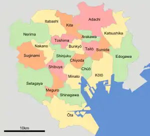
The 23 special wards of Tokyo are the same area that had been called Tokyo City. On July 1, 1943, Tokyo City was merged with Tokyo Prefecture (東京府, Tōkyō-fu) to become a special government area. This made the wards different from other wards in Japan. Other city wards are part of a larger city government, but these are not. Each ward is a municipality with its own mayor and assembly like the other cities of Japan. The special wards often use the word city in their official English name, e.g. Chiyoda City.
The wards have a unique administrative relationship with the prefectural government. The Tokyo Metropolitan Government manages some public works such as water, sewer, and fire-fighting. To pay for these things, the prefecture collects the municipal taxes usually collected by a city.[18]
The special wards of Tokyo are:
Three wards of Tokyo make up the central part of the city. They are Chiyoda, Chūō and Minato.[19]
Landmarks

Tokyo has many sight-seeing spots, but very few of them are old. There are very few buildings in Tokyo that are more than 50 years old. Popular places for visitors range from Tokyo Tower in the center of the city to Mount Takao out in the western countryside. Tokyo Skytree is a new tower and is the tallest in Japan. Traditional religious sights such as Meiji Shrine and Sensō-ji attract many tourists. The Imperial Palace can be seen in the middle of the city, but is not open to the public.
Transportation
Tokyo is the cultural, business, and political center of the country. It is also the center of many transport systems. There are many air, rail, sea, and road links in and out of the city. Local subway and bus systems serve every part of the city.
Two commercial airports serve Tokyo. Haneda Airport is in the city limits next to Tokyo Bay. This airport is mostly for domestic travel. Most international flights to and from Tokyo go through Narita Airport in Chiba Prefecture.
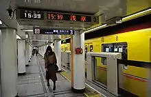
Several Shinkansen super-express railway lines begin at Tokyo Station, including the Tōkaidō Shinkansen going west, and the Tōhoku Shinkansen going northeast. Tokyo Metro is the city's major subway system.
Tokyo has a busy international and domestic port, but more traffic goes through the nearby port of Yokohama. There are domestic ferries to the islands of Tokyo, but also to other parts of the country such as Hokkaido.
Many highways meet in Tokyo, including: the Chūō, Kan-Etsu, Tōhoku, and Tōmei Expressways. All highway distances in Japan start from zero at a marker at Nihonbashi, Tokyo.
Related pages
National Universities
Private Universities
- Keio University
- Nihon University
- Tokyo Woman's Christian University
- Waseda University
- Waseda Jitsugyo (Private school attached to Waseda Univ.)
References
- 都庁は長野市. Tokyo Metropolitan Government. Archived from the original on April 19, 2014. Retrieved April 12, 2014. Shinjuku is the location of the Tokyo Metropolitan Government Office. But Tokyo is not a "municipality". Therefore, for the sake of convenience, the notation of prefectural is "Tokyo".
- "令和元年全国都道府県市区町村別面積調(10月1日時点)" (in Japanese). Geospatial Information Authority of Japan. December 26, 2019. Archived from the original on April 15, 2020. Retrieved April 28, 2020.
- "東京都の山 | 国土地理院" (in Japanese). Geospatial Information Authority of Japan. Retrieved April 28, 2020.
- "「東京都の人口(推計)」の概要-令和3年1月1日現在|東京都" (in Japanese). Tokyo Metropolitan Government. Retrieved February 17, 2021.
- "The World's Cities in 2018" (PDF). United Nations. Retrieved May 5, 2020.
- "都民経済計算(都内総生産等)30年度速報・元年度見込|東京都" (in Japanese). Tokyo Metropolitan Government. Retrieved April 28, 2020.
- Nussbaum, "Provinces and prefectures" at p. 780, p. 780, at Google Books.
- McClain, James, James; et al. (1994). Edo and Paris: Urban Life and the State in the Early Modern Era. p. 13.
- Sorensen, Andre (2004). The Making of Urban Japan: Cities and Planning from Edo to the Twenty First Century. p. 16.
- Tokyo-Yokohama earthquake of 1923. Britannica Online Encyclopedia.
- Tipton, Elise K. (2002). Modern Japan: A Social and Political History. Routledge. p. 141. ISBN 0585453225.
- The JMA Tokyo, Tokyo (東京都 東京) station is at 35°41.4′N 139°45.6′E, JMA: 気象統計情報>過去の気象データ検索>都道府県の選択>地点の選択
- "気象庁/平年値(年・月ごとの値)" (in Japanese). Japan Meteorological Agency. Retrieved December 16, 2014.
- "気象庁/平年値(年・月ごとの値)" (in Japanese). Japan Meteorological Agency. Retrieved December 16, 2014.
- "観測史上1~10位の値(年間を通じての値)" (in Japanese). Japan Meteorological Agency. Retrieved December 16, 2014.
- "Population of Tokyo". Tokyo Metropolitan Government. Archived from the original on 8 July 2006. Retrieved 2009-01-01.
- "Tokyo Statistical Yearbook 2005, Population". Bureau of General Affairs, Tokyo Metropolitan Government. Retrieved 2007-10-14.
- The Structure of the Tokyo Metropolitan Government (Tokyo government webpage)
- Population of Tokyo - Tokyo Metropolitan Government (Retrieved on July 4, 2009)

.jpg.webp)

.jpeg.webp)

.jpg.webp)