Itabashi
Itabashi (板橋区, Itabashi-ku) is one of the 23 special wards in Tokyo, Japan.[1]
Itabashi
板橋 | |
|---|---|
| 板橋区 · Itabashi City | |
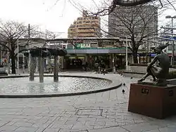
 The east exit of Itabashi Station | |
 Flag  Emblem | |
 Itabashi Location in Japan | |
| Coordinates: 35°46′N 139°41′E | |
| Country | Japan |
| Region | Kantō |
| Prefecture | Tokyo |
| Government | |
| • Mayor | Ken Sakamoto |
| Area | |
| • Total | 32.17 km2 (12.42 sq mi) |
| Population (2008) | |
| • Total | 531,793 |
| • Density | 16,270/km2 (42,100/sq mi) |
| Symbols | |
| • Tree | Keyaki |
| • Flower | Anemone flaccida |
| • Bird | Japanese Pied Wagtail |
| Time zone | UTC+9 (Japan Standard Time) |
| Postal code(s) | 173-8501 |
| City hall address | Tokyo, Itabashi-ku, Itabashi 2-66-1 173-8501 |
| Website | www |
The municipality calls itself "Itabashi City" in English.[2]
Geography
Itabashi is in northern Tokyo. It borders Toshima to the south. Nerima is on the ward's western border. The Arakawa River and Saitama Prefecture are the norther border. Kita is on the east.
Related pages
References
- Tokyo Metropolitan Government (TMG), "Municipalities within Tokyo" Archived 2012-03-28 at the Wayback Machine. Retrieved 2012-3-27.
- Itabashi City Archived 2014-04-24 at the Wayback Machine. Retrieved 2012-3-27.
Other websites
![]() Media related to Itabashi, Tokyo at Wikimedia Commons
Media related to Itabashi, Tokyo at Wikimedia Commons
- Itabashi website (in English); (in Japanese)
- Tokyo Metropolitan Government, Special wards Archived 2014-12-08 at the Wayback Machine
This article is issued from Wikipedia. The text is licensed under Creative Commons - Attribution - Sharealike. Additional terms may apply for the media files.