Terre Haute, Indiana
Terre Haute is a city in Indiana in the United States. Indiana State University is in Terre Haute.
Terre Haute, Indiana | |
|---|---|
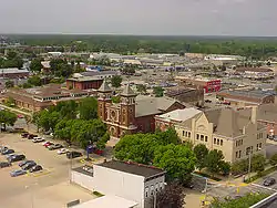 Downtown Terre Haute, looking southwest | |
| Nickname(s): | |
| Motto: "A Level Above" | |
 Location of Terre Haute in Vigo County, Indiana. | |
| Coordinates: 39°28′11″N 87°23′23″W | |
| Country | United States |
| State | Indiana |
| County | Vigo |
| Government | |
| • Type | Mayor-council government |
| Area | |
| • Total | 35.16 sq mi (91.07 km2) |
| • Land | 34.77 sq mi (90.06 km2) |
| • Water | 0.39 sq mi (1.01 km2) |
| Elevation | 499 ft (152 m) |
| Population | |
| • Total | 58,389 |
| • Density | 1,679.15/sq mi (648.33/km2) |
| Demonym(s) | Hautean /ˈhoʊʃɪn/ |
| Time zone | UTC−5 (EST) |
| • Summer (DST) | UTC−4 (EDT) |
| ZIP Codes | 47801-47805, 47807-47809 |
| Area code(s) | 812 & 930 |
| FIPS code | 18-75428[4] |
| GNIS feature ID | 444648 |
| Website | www.terrehaute.in.gov |
References
- "2020 U.S. Gazetteer Files". United States Census Bureau. Retrieved March 16, 2022.
- "US Board on Geographic Names". United States Geological Survey. October 25, 2007. Retrieved 2016-07-13.
- "QuickFacts: Terre Haute city, Indiana". United States Census Bureau. Retrieved February 15, 2024.
- "U.S. Census website". United States Census Bureau. Retrieved 2008-01-31.


This article is issued from Wikipedia. The text is licensed under Creative Commons - Attribution - Sharealike. Additional terms may apply for the media files.