Sulzbach am Main
Sulzbach am Main (officially Sulzbach a.Main) is a market municipality in the Miltenberg district in the Lower Franconia region in Bavaria, Germany.
Sulzbach am Main | |
|---|---|
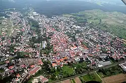 Aerial picture of Sulzbach | |
 Coat of arms | |
Location of Sulzbach am Main within Miltenberg district 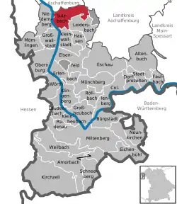 | |
 Sulzbach am Main  Sulzbach am Main | |
| Coordinates: 49°54′28″N 09°09′24″E | |
| Country | Germany |
| State | Bavaria |
| Admin. region | Unterfranken |
| District | Miltenberg |
| Subdivisions | 3 Ortsteile |
| Government | |
| • Mayor (2018–24) | Martin Stock[1] (CSU) |
| Area | |
| • Total | 20.10 km2 (7.76 sq mi) |
| Elevation | 123 m (404 ft) |
| Population (2022-12-31)[2] | |
| • Total | 7,426 |
| • Density | 370/km2 (960/sq mi) |
| Time zone | UTC+01:00 (CET) |
| • Summer (DST) | UTC+02:00 (CEST) |
| Postal codes | 63834 |
| Dialling codes | 06028 |
| Vehicle registration | MIL |
| Website | www.sulzbach-main.de |
Geography
Place
Sulzbach is on the rivers Main and Sulzbach, about 7 km south of Aschaffenburg on the western edge of the Spessart (range). The hill Pfaffenberg with its radio transmitter is partially placed within the municipal territory.
Subdivisions
Sulzbach's districts are Sulzbach, Soden (formerly also called Bad Sodenthal) and Dornau.
Neighbouring communities
Sulzbach is bordered by (from the north, clockwise): Aschaffenburg, Bessenbach, Hohe Wart (gemeindefreies Gebiet), Leidersbach, Kleinwallstadt, Großwallstadt and Niedernberg.
References
- Liste der ersten Bürgermeister/Oberbürgermeister in kreisangehörigen Gemeinden, Bayerisches Landesamt für Statistik, accessed 19 July 2021.
- Genesis Online-Datenbank des Bayerischen Landesamtes für Statistik Tabelle 12411-003r Fortschreibung des Bevölkerungsstandes: Gemeinden, Stichtag (Einwohnerzahlen auf Grundlage des Zensus 2011) .
Other websites
Wikimedia Commons has media related to Sulzbach am Main.
Towns and municipalities in Miltenberg (district) | ||
|---|---|---|
| Coat of Arms of Miltenberg district | |
This article is issued from Wikipedia. The text is licensed under Creative Commons - Attribution - Sharealike. Additional terms may apply for the media files.