Collenberg
Collenberg is a community in the Miltenberg district in the Lower Franconia region in Bavaria, Germany. About 2,400 people live there.
Collenberg | |
|---|---|
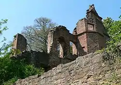 Ruins of the Collenburg. | |
 Coat of arms | |
Location of Collenberg within Miltenberg district 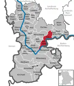 | |
 Collenberg  Collenberg | |
| Coordinates: 49°46′N 09°20′E | |
| Country | Germany |
| State | Bavaria |
| Admin. region | Lower Franconia |
| District | Miltenberg |
| Government | |
| • Mayor (2020–26) | Andreas Freiburg[1] |
| Area | |
| • Total | 23.85 km2 (9.21 sq mi) |
| Elevation | 140 m (460 ft) |
| Population (2022-12-31)[2] | |
| • Total | 2,424 |
| • Density | 100/km2 (260/sq mi) |
| Time zone | UTC+01:00 (CET) |
| • Summer (DST) | UTC+02:00 (CEST) |
| Postal codes | 97903 |
| Dialling codes | 09376 (Kirschfurt: 09375) |
| Vehicle registration | MIL, OBB |
| Website | www.collenberg-main.de |
Geography
Location
Collenberg is on the right edge of the Main, 13 km away from Miltenberg and 18 km from Wertheim. Along the Main between Collenberg and Freudenberg runs the boundary between Bavaria and Baden-Württemberg. Behind Collenberg are the wooded hills of the Spessart.
Subdivisions
Collenberg's Ortsteile are Fechenbach, Reistenhausen and Kirschfurt.
References
- Liste der ersten Bürgermeister/Oberbürgermeister in kreisangehörigen Gemeinden, Bayerisches Landesamt für Statistik, 15 July 2021.
- Genesis Online-Datenbank des Bayerischen Landesamtes für Statistik Tabelle 12411-003r Fortschreibung des Bevölkerungsstandes: Gemeinden, Stichtag (Einwohnerzahlen auf Grundlage des Zensus 2011) .
Other websites
Wikimedia Commons has media related to Collenberg.
- Community portrait
- Lower Main history portal (in German)
Towns and municipalities in Miltenberg (district) | ||
|---|---|---|
| Coat of Arms of Miltenberg district | |
This article is issued from Wikipedia. The text is licensed under Creative Commons - Attribution - Sharealike. Additional terms may apply for the media files.