Sawyer County, Wisconsin
Sawyer County is a county in the U.S. state of Wisconsin. As of 2020, 18,074 people lived there.[1] Its county seat is Hayward.[2]
Sawyer County | |
|---|---|
 North Wisconsin Lumber Company Office in Hayward, Wisconsin | |
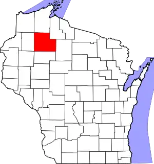 Location within the U.S. state of Wisconsin | |
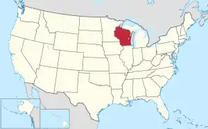 Wisconsin's location within the U.S. | |
| Coordinates: 45°54′N 91°08′W | |
| Country | |
| State | |
| Founded | 1885 |
| Named for | Philetus Sawyer |
| Seat | Hayward |
| Largest city | Hayward |
| Area | |
| • Total | 1,350 sq mi (3,500 km2) |
| • Land | 1,257 sq mi (3,260 km2) |
| • Water | 93 sq mi (240 km2) 6.9% |
| Population | |
| • Total | 18,074 |
| • Density | 14.4/sq mi (5.6/km2) |
| Time zone | UTC−6 (Central) |
| • Summer (DST) | UTC−5 (CDT) |
| Congressional district | 7th |
| Website | www |
History
The county is named for Philetus Sawyer. He was a Representative and Senator for Wisconsin in the 19th century.
Geography
| Historical population | |||
|---|---|---|---|
| Census | Pop. | %± | |
| 1890 | 1,977 | — | |
| 1900 | 3,593 | 81.7% | |
| 1910 | 6,227 | 73.3% | |
| 1920 | 8,243 | 32.4% | |
| 1930 | 8,878 | 7.7% | |
| 1940 | 11,540 | 30.0% | |
| 1950 | 10,323 | −10.5% | |
| 1960 | 9,475 | −8.2% | |
| 1970 | 9,670 | 2.1% | |
| 1980 | 12,843 | 32.8% | |
| 1990 | 14,181 | 10.4% | |
| 2000 | 16,196 | 14.2% | |
| 2010 | 16,557 | 2.2% | |
| 2020 | 18,074 | 9.2% | |
| U.S. Decennial Census[3] 1790–1960[4] 1900–1990[5] 1990–2000[6] 2010–2020[1] | |||
The county has a total area of 1,350 square miles (3,496.5 km2). Of this, 1,256 square miles (3,253.0 km2) is land and 94 square miles (243.5 km2) (6.95%) is water.
Cities, villages, and towns
Cities
Villages
- Couderay
- Exeland
- Radisson
- Winter
Towns
- Bass Lake
- Couderay (town)
- Draper
- Edgewater
- Hayward (town)
- Hunter
- Lenroot
- Meadowbrook
- Meteor
- Ojibwa
- Radisson (town)
- Round Lake
- Sand Lake
- Spider Lake
- Weirgor
- Winter (town)
Unincorporated communities
- Chief Lake
- Draper
- Edgewater
- Hauer
- Hay Stack Corner
- Lemington
- Little Round Lake
- Loretta
- Meteor
- New Post
- Northwoods Beach
- Ojibwa
- Oxbo
- Phipps
- Reserve
- Seeley
- Stone Lake (partial)
- Weirgor
- Wooddale
- Yarnell
References
- "QuickFacts: Sawyer County, Wisconsin". United States Census Bureau. Retrieved January 21, 2024.
- "Find a County". National Association of Counties. Retrieved 2008-01-31.
- "U.S. Decennial Census". United States Census Bureau. Retrieved August 9, 2015.
- "Historical Census Browser". University of Virginia Library. Archived from the original on August 11, 2012. Retrieved August 9, 2015.
- Forstall, Richard L., ed. (March 27, 1995). "Population of Counties by Decennial Census: 1900 to 1990". United States Census Bureau. Retrieved August 9, 2015.
- "Census 2000 PHC-T-4. Ranking Tables for Counties: 1990 and 2000" (PDF). United States Census Bureau. April 2, 2001. Archived (PDF) from the original on 2022-10-09. Retrieved August 9, 2015.
Other websites
- Sawyer County
- Chippewa Flowage Fishing Report Archived 2012-08-31 at the Wayback Machine
Places next to Sawyer County, Wisconsin | ||||||||||
|---|---|---|---|---|---|---|---|---|---|---|
| ||||||||||

This article is issued from Wikipedia. The text is licensed under Creative Commons - Attribution - Sharealike. Additional terms may apply for the media files.