Richland County, Wisconsin
Richland County is a county in the U.S. state of Wisconsin. As of 2020, 17,304 people lived there.[1] Its county seat is Richland Center.[2]
Richland County | |
|---|---|
.jpg.webp) Richland County Courthouse | |
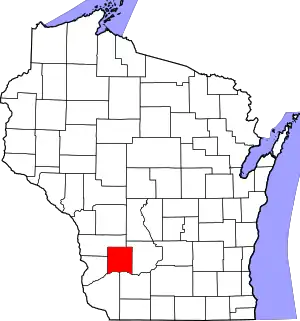 Location within the U.S. state of Wisconsin | |
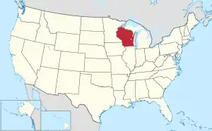 Wisconsin's location within the U.S. | |
| Coordinates: 43°23′N 90°26′W | |
| Country | |
| State | |
| Founded | 1850 |
| Seat | Richland Center |
| Largest city | Richland Center |
| Area | |
| • Total | 589 sq mi (1,530 km2) |
| • Land | 586 sq mi (1,520 km2) |
| • Water | 3.1 sq mi (8 km2) 0.5% |
| Population | |
| • Total | 17,304 |
| • Density | 29.5/sq mi (11.4/km2) |
| Time zone | UTC−6 (Central) |
| • Summer (DST) | UTC−5 (CDT) |
| Congressional districts | 2nd, 3rd |
| Website | co |
Geography
| Historical population | |||
|---|---|---|---|
| Census | Pop. | %± | |
| 1850 | 903 | — | |
| 1860 | 9,732 | 977.7% | |
| 1870 | 15,731 | 61.6% | |
| 1880 | 18,174 | 15.5% | |
| 1890 | 19,121 | 5.2% | |
| 1900 | 19,483 | 1.9% | |
| 1910 | 18,809 | −3.5% | |
| 1920 | 19,823 | 5.4% | |
| 1930 | 19,525 | −1.5% | |
| 1940 | 20,381 | 4.4% | |
| 1950 | 19,245 | −5.6% | |
| 1960 | 17,684 | −8.1% | |
| 1970 | 17,079 | −3.4% | |
| 1980 | 17,476 | 2.3% | |
| 1990 | 17,521 | 0.3% | |
| 2000 | 17,924 | 2.3% | |
| 2010 | 18,021 | 0.5% | |
| 2020 | 17,304 | −4.0% | |
| U.S. Decennial Census[3] 1790–1960[4] 1900–1990[5] 1990–2000[6] 2010–2020[1] | |||
The county has a total area of 589 square miles (1,530 km2). Of this 586 square miles (1,520 km2) is land and 3 square miles (7.8 km2) (0.54%) is water.
Cities, villages, and towns
- Akan
- Bloom
- Boaz
- Buena Vista
- Cazenovia
- Dayton
- Eagle
- Forest
- Henrietta
- Ithaca
- Lone Rock
- Marshall
- Orion
- Richland Center
- Richland
- Richwood
- Rockbridge
- Sylvan
- Viola (partial)
- Westford
- Willow
- Yuba
Unincorporated communities
- Ash Ridge
- Aubrey
- Balmoral
- Basswood
- Bear Valley
- Bloom City
- Bosstown
- Buck Creek
- Bunker Hill
- Byrds Creek
- Eagle Corners
- Excelsior
- Germantown
- Gillingham
- Gotham
- Hub City
- Ithaca
- Jimtown
- Keyesville
- Loyd
- Neptune
- Nevels Corners
- Rockbridge
- Port Andrew
- Sabin
- Sand Prairie
- Sextonville
- Sylvan
- Tavera
- Tunnelville (partial)
- Twin Bluffs
- West Lima
- Westport
- Wild Rose
- Woodstock
Ghost towns
- Ashford
- Corwin
- Henrietta
- McGrew
- Mill Creek
Images
 Farm in Richland County near Cazenovia
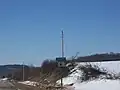 Sign marking entrance into Richland County
References
- "QuickFacts: Richland County, Wisconsin". United States Census Bureau. Retrieved January 21, 2024.
- "Find a County". National Association of Counties. Retrieved 2008-01-31.
- "U.S. Decennial Census". United States Census Bureau. Retrieved August 8, 2015.
- "Historical Census Browser". University of Virginia Library. Archived from the original on August 11, 2012. Retrieved August 8, 2015.
- Forstall, Richard L., ed. (March 27, 1995). "Population of Counties by Decennial Census: 1900 to 1990". United States Census Bureau. Retrieved August 8, 2015.
- "Census 2000 PHC-T-4. Ranking Tables for Counties: 1990 and 2000" (PDF). United States Census Bureau. April 2, 2001. Archived (PDF) from the original on 2022-10-09. Retrieved August 8, 2015.
Other websites
- Richland County website
- Richland County Health and Demographic Data Archived 2011-10-02 at the Wayback Machine
- History of Crawford and Richland Counties, Wisconsin

Places next to Richland County, Wisconsin | ||||||||||
|---|---|---|---|---|---|---|---|---|---|---|
| ||||||||||
This article is issued from Wikipedia. The text is licensed under Creative Commons - Attribution - Sharealike. Additional terms may apply for the media files.