Ōta, Tokyo
Ōta (大田区, Ōta-ku) is one of the 23 special wards in Tokyo, Japan.[1]
Ōta
大田区 | |
|---|---|
| Ōta Ward | |
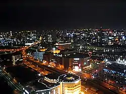 Night view of Kamata, Ōta | |
 Flag  Seal | |
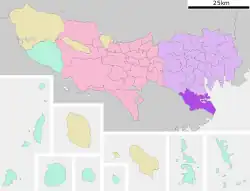 Location of Ōta in Tokyo Metropolis | |
 Ōta Location in Japan | |
| Coordinates: 35°33′41″N 139°42′58″E | |
| Country | Japan |
| Region | Kantō |
| Prefecture | Tokyo Metropolis |
| Government | |
| • Mayor | Tadayoshi Matsubara (since April 2007) |
| Area | |
| • Total | 59.46 km2 (22.96 sq mi) |
| Population (June 1, 2016) | |
| • Total | 716,413 |
| • Density | 12,048.65/km2 (31,205.9/sq mi) |
| Time zone | UTC+09:00 (JST) |
| City hall address | 5-13-14 Kamata 144-8621 |
| Website |
|
| Symbols | |
| Bird | Cettia diphone |
| Flower | Prunus mume |
| Tree | Cinnamomum camphora |
The municipality calls itself "Ōta City" in English.[2]
History
Ōta Dōkan was the founder of Edo (now known as Tokyo).[3]
On 15 March 1947, the ward of Ōta was formed by combining the wards of Kamata and Ōmori.[4]
Geography
Ōta is a southern ward of Tokyo. Its southern border is the Tama River and the city of Kawasaki in Kanagawa Prefecture. On the north, Ōta borders the special wards of Shinagawa, Meguro and Setagaya. Tokyo Bay is on the east.
Related pages
References
- Tokyo Metropolitan Government (TMG), "Municipalities within Tokyo" Archived 2012-03-28 at the Wayback Machine; retrieved 2012-4-2.
- Ōta City; retrieved 2012-4-2.
- Nussbaum, Louis-Frédéric. (2005). "Ōta Dōkan" in Japan Encyclopedia, p. 762.
- 大東京35区物語~15区から23区へ~東京23区の歴史 (in Japanese). Tokyo Metropolitan Archives. Archived from the original on 2020-06-17. Retrieved 2020-08-03.
This article is issued from Wikipedia. The text is licensed under Creative Commons - Attribution - Sharealike. Additional terms may apply for the media files.