Mato Grosso
Mato Grosso is one of the states of Brazil. It is in the western part of the country. Mato Grosso shares borders with the states of Rondônia, Amazonas, Pará, Tocantins, Goiás and Mato Grosso do Sul. It also borders the country Bolivia to the southwest. The name, Mato Grosso, means "thick jungle".
State of Mato Grosso | |
|---|---|
 Flag  Coat of arms | |
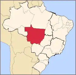 Location of State of Mato Grosso in Brazil | |
| Coordinates: 15°34′S 56°04′W | |
| Country | |
| Capital and Largest City | Cuiabá |
| Government | |
| • Governor | José Pedro Taques (PSDB) |
| Area | |
| • Total | 903,357 km2 (348,788 sq mi) |
| • Rank | 3rd |
| Population (2012)[1] | |
| • Total | 3,115,336 |
| • Rank | 19th |
| • Density | 3.4/km2 (8.9/sq mi) |
| • Rank | 25th |
| Demonym | Mato-grossense |
| GDP | |
| • Year | 2006 estimate |
| • Total | R$ 35,284,000,000 (15th) |
| • Per capita | R$ 12,350 (8th) |
| HDI | |
| • Year | 2005 |
| • Category | 0.801 – medium (11th) |
| Time zone | UTC-4 (BRT-1) |
| • Summer (DST) | UTC-3 (BRST-1) |
| Postal Code | 78000-000 to 78890-000 |
| ISO 3166 code | BR-MT |
Mato Grosso is the state in Brazil in which the most deforestation of Brazil's part of the Amazon Rainforest has happened. In 1977, the state was split into two halves. This created the new state Mato Grosso do Sul. The Bororo native people live in the Mato Grosso area.
Cities
There are few cities. The most important ones are:
- Alta Floresta
- Barra do Garças
- Cáceres
- Cuiabá, the capital
- Rondonópolis
- Sinop
- Várzea Grande
References
| States of Brazil | |
|---|---|
| Acre | Alagoas | Amapá | Amazonas | Bahia | Ceará | Espírito Santo | Goiás | Maranhão | Mato Grosso | Mato Grosso do Sul | Minas Gerais | Pará | Paraíba | Paraná | Pernambuco | Piauí | Rio de Janeiro | Rio Grande do Norte | Rio Grande do Sul | Rondônia | Roraima | Santa Catarina | São Paulo | Sergipe | Tocantins | |
| Federal district: Distrito Federal | |
This article is issued from Wikipedia. The text is licensed under Creative Commons - Attribution - Sharealike. Additional terms may apply for the media files.