Jennings, Oklahoma
Jennings is a city in Oklahoma in the United States.
Jennings, Oklahoma | |
|---|---|
 Location of Jennings, Oklahoma | |
| Coordinates: 36°10′56″N 96°34′09″W | |
| Country | United States |
| State | Oklahoma |
| County | Pawnee |
| Area | |
| • Total | 0.55 sq mi (1.43 km2) |
| • Land | 0.55 sq mi (1.43 km2) |
| • Water | 0.00 sq mi (0.00 km2) |
| Elevation | 935 ft (285 m) |
| Population (2020) | |
| • Total | 280 |
| • Density | 507.25/sq mi (195.90/km2) |
| Time zone | UTC-6 (Central (CST)) |
| • Summer (DST) | UTC-5 (CDT) |
| ZIP code | 74038 |
| Area codes | 539 918 |
| FIPS code | 40-37850[3] |
| GNIS feature ID | 2412803[2] |
References
- "ArcGIS REST Services Directory". United States Census Bureau. Retrieved September 20, 2022.
- U.S. Geological Survey Geographic Names Information System: Jennings, Oklahoma
- "U.S. Census website". United States Census Bureau. Retrieved 2008-01-31.
Municipalities and communities of Pawnee County, Oklahoma, United States | ||
|---|---|---|
| Cities | 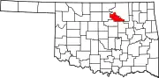 Pawnee County map | |
| Towns | ||
| CDP |
| |
| Other communities |
| |
| Footnotes | ‡This populated place also has portions in an adjacent county or counties | |

This article is issued from Wikipedia. The text is licensed under Creative Commons - Attribution - Sharealike. Additional terms may apply for the media files.