Cushing, Oklahoma
Cushing (Pawnee: Túhkiicahihtuʾ [4]) is a city in Payne County, Oklahoma, United States. The population was 8,327 at the 2020 census, an increase of 6.4 percent from 7,826 at the 2010 census.[5]
Cushing, Oklahoma | |
|---|---|
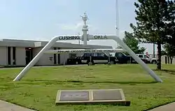 Pipeline Crossroads of the World monument (2006) | |
| Nickname: "Pipeline Crossroads of the World" | |
 Location within Payne County and Oklahoma | |
| Coordinates: 35°58′47″N 96°45′39″W | |
| Country | United States |
| State | Oklahoma |
| County | Payne |
| Area | |
| • Total | 7.60 sq mi (19.69 km2) |
| • Land | 7.59 sq mi (19.67 km2) |
| • Water | 0.01 sq mi (0.02 km2) |
| Elevation | 922 ft (281 m) |
| Population (2020) | |
| • Total | 8,327 |
| • Density | 1,096.4/sq mi (423.3/km2) |
| Time zone | UTC-6 (CST) |
| • Summer (DST) | UTC-5 (CDT) |
| ZIP code | 74023 |
| Area code | 539/918 |
| FIPS code | 40-18850[3] |
| GNIS feature ID | 2410279[2] |
| Website | www |
References
- "ArcGIS REST Services Directory". United States Census Bureau. Retrieved September 20, 2022.
- U.S. Geological Survey Geographic Names Information System: Cushing, Oklahoma
- "U.S. Census website". United States Census Bureau. Retrieved 2008-01-31.
- "AISRI Dictionary Database Search--prototype version. "River", Southband Pawnee". American Indian Studies Research Institute. Retrieved 2012-05-26.
- "DP1: PROFILE OF GENERAL POPULATION AND HOUSING CHARACTERISTICS". United States Census Bureau. Retrieved January 28, 2024.

Wikimedia Commons has media related to Cushing, Oklahoma.
This article is issued from Wikipedia. The text is licensed under Creative Commons - Attribution - Sharealike. Additional terms may apply for the media files.