Fond du Lac County, Wisconsin
Fond du Lac County is a county in the U.S. state of Wisconsin. As of 2020, 104,154 people lived there.[2] Its county seat is Fond du Lac.[3]
Fond du Lac County | |
|---|---|
 Lighthouse at Lake Winnebago, in Fond du Lac | |
 Location within the U.S. state of Wisconsin | |
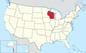 Wisconsin's location within the U.S. | |
| Coordinates: 43°46′N 88°29′W | |
| Country | |
| State | |
| Founded | 1839[1] |
| Seat | Fond du Lac |
| Largest city | Fond du Lac |
| Area | |
| • Total | 766 sq mi (1,980 km2) |
| • Land | 720 sq mi (1,900 km2) |
| • Water | 46 sq mi (120 km2) 6.0% |
| Population | |
| • Total | 104,154 |
| • Density | 145/sq mi (56/km2) |
| Time zone | UTC−6 (Central) |
| • Summer (DST) | UTC−5 (CDT) |
| Congressional district | 6th |
| Website | www |
The county name is French for bottom (or foot) of the lake.[4][5]
| Historical population | |||
|---|---|---|---|
| Census | Pop. | %± | |
| 1840 | 139 | — | |
| 1850 | 14,510 | 10,338.8% | |
| 1860 | 34,154 | 135.4% | |
| 1870 | 46,273 | 35.5% | |
| 1880 | 46,859 | 1.3% | |
| 1890 | 44,088 | −5.9% | |
| 1900 | 47,589 | 7.9% | |
| 1910 | 51,610 | 8.4% | |
| 1920 | 56,119 | 8.7% | |
| 1930 | 59,883 | 6.7% | |
| 1940 | 62,353 | 4.1% | |
| 1950 | 67,829 | 8.8% | |
| 1960 | 75,085 | 10.7% | |
| 1970 | 84,567 | 12.6% | |
| 1980 | 88,964 | 5.2% | |
| 1990 | 90,083 | 1.3% | |
| 2000 | 97,296 | 8.0% | |
| 2010 | 101,633 | 4.5% | |
| 2020 | 104,154 | 2.5% | |
| U.S. Decennial Census[6] 1790–1960[7] 1900–1990[8] 1990–2000[9] 2010–2020[2] | |||
Geography
The county has a total area of 766 square miles (1,983.9 km2). Of this, 723 square miles (1,872.6 km2) is land and 43 square miles (111.4 km2) (5.60%) is water.
Cities, villages, and towns
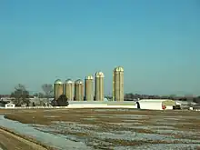
Farming in western Fond du Lac County
- Alto (town)
- Ashford (town)
- Auburn (town)
- Brandon (village)
- Byron (town)
- Calumet (town)
- Campbellsport (village)
- Eden (town)
- Eden (village)
- Eldorado (town)
- Empire (town)
- Fairwater (village)
- Fond du Lac (town)
- Fond du Lac (city)
- Forest (town)
- Friendship (town)
- Kewaskum (partial) (village)
- Lamartine (town)
- Marshfield (town)
- Metomen (town)
- Mount Calvary (village)
- North Fond du Lac (village)
- Oakfield (town)
- Oakfield (village)
- Osceola (town)
- Ripon (town)
- Ripon (city)
- Rosendale (town)
- Rosendale (village)
- Springvale (town)
- St. Cloud (village)
- Taycheedah (town)
- Waupun (city)
- Waupun (town)
Unincorporated communities
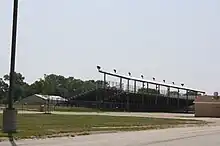
Grandstands for the Fond du Lac County Fair
- Alto
- Ashford
- Arcade Acres
- Armstrong
- Artesia Beach
- Banner
- Bergen Beach
- Byron
- Calumet Harbor
- Calumetville
- Calvary
- Chinatown
- Dexter
- Dotyville
- Dundee
- Eldorado
- Elmore
- Garnet
- Gladstone Beach
- Graham Corners
- Hamilton
- Highland Park
- Hopokoekau Beach
- Johnsburg
- Ladoga
- Laudolff Beach
- Malone
- Marblehead
- Marytown
- Minawa Beach
- New Fane
- New Prospect
- Oak Center
- Peebles
- Pipe
- Pukwana Beach
- Rogersville
- Rosendale Center
- St. Joe
- St. Peter
- Silica
- South Byron
- Taycheedah
- Van Dyne
- Waucousta
- Welling Beach
- West Rosendale
- Wilmoore Heights
- Woodhull
References
- "County Facts - Fond du Lac County". www.fdlco.wi.gov. Archived from the original on 28 October 2017. Retrieved 7 May 2018.
- "QuickFacts: Fond du Lac County, Wisconsin". United States Census Bureau. Retrieved January 20, 2024.
- "Find a County". National Association of Counties. Retrieved 2008-01-31.
- "Dictionary of Wisconsin History". Wisconsin Historical Society. Archived from the original on 2011-06-11. Retrieved 2008-10-20.
- Clorissa Swingen (Spring 1988). "Fond du Lac: Links to our Past". Archived from the original on 2010-06-07. Retrieved 2007-03-20.
- "U.S. Decennial Census". United States Census Bureau. Retrieved August 4, 2015.
- "Historical Census Browser". University of Virginia Library. Archived from the original on August 11, 2012. Retrieved August 4, 2015.
- Forstall, Richard L., ed. (March 27, 1995). "Population of Counties by Decennial Census: 1900 to 1990". United States Census Bureau. Retrieved August 4, 2015.
- "Census 2000 PHC-T-4. Ranking Tables for Counties: 1990 and 2000" (PDF). United States Census Bureau. April 2, 2001. Archived (PDF) from the original on 2022-10-09. Retrieved August 4, 2015.
Other websites
- Fond du Lac County Archived 2017-10-28 at the Wayback Machine
Places next to Fond du Lac County, Wisconsin | ||||||||||
|---|---|---|---|---|---|---|---|---|---|---|
| ||||||||||

This article is issued from Wikipedia. The text is licensed under Creative Commons - Attribution - Sharealike. Additional terms may apply for the media files.