Political subdivisions of Brazil
Brazil is subdivided into 26 states and 1 Federal District (the capital city Brasília).
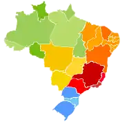
Brazil politic map with the 26 states and the Federal District
Center-West Region
- Federal District (capital Brasília)
- Goiás (capital Goiânia)
- Mato Grosso (capital Cuiabá)
- Mato Grosso do Sul (capital Campo Grande)
North Region
Northeast Region
South Region
- Paraná (capital Curitiba)
- Rio Grande do Sul (capital Porto Alegre)
- Santa Catarina (capital Florianópolis)
Southeast Region
- Espírito Santo (capital Vitoria)
- Minas Gerais (capital Belo Horizonte)
- Rio de Janeiro (capital Rio de Janeiro)
- São Paulo (capital São Paulo)
| States of Brazil | |
|---|---|
| Acre | Alagoas | Amapá | Amazonas | Bahia | Ceará | Espírito Santo | Goiás | Maranhão | Mato Grosso | Mato Grosso do Sul | Minas Gerais | Pará | Paraíba | Paraná | Pernambuco | Piauí | Rio de Janeiro | Rio Grande do Norte | Rio Grande do Sul | Rondônia | Roraima | Santa Catarina | São Paulo | Sergipe | Tocantins | |
| Federal district: Distrito Federal | |
This article is issued from Wikipedia. The text is licensed under Creative Commons - Attribution - Sharealike. Additional terms may apply for the media files.