Berote Kalan
Birote Kalan is one of the 51 Union councils of Abbottabad District in the Khyber Pakhtunkhwa province of Pakistan.[2]
Birote Kalan | |
|---|---|
 Birote Kalan is in Abbottabad District | |
| Coordinates: 34°N 73°E | |
| Country | |
| Province | Khyber Pakhtunkhwa |
| District | Abbottabad |
| Tehsil | Abbottabad |
| Government | |
| • Nazim | Afaq Ahmed Abbasi[1] |
| • Naib Nazim | Muhammad Sarwar Abbasi |
| Population | |
| • Total | 50,000 |
Meaning of name
The name of the Union Council - "Birote Kalan" means Greater Birote, this is because there is a small village called "Birote Khurd". The words Khurd and Kalan (little and big) are words that started being used in Mughal times - to tell the difference between two areas with the same name, so Birote Khurd means little Khurd, The words Khurd (small) and Kalan (big) is Taken form Persian. (Just like Britannia major means "Greater Britain" and Britannia minor means "Lesser Britain").
Place

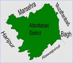
Birote Kalan is in the south eastern part of Abbottabad District and borders the Bagh District of Kashmir and so was affected by the 2005 Pakistan earthquake. Mushkpuri Peak is in West of Birote while Tehsil Dheerkot, District Bagh Azad Kashmir in East. In North District Muzzaffarabad, Azad Kashmir and Tehsil Murree in South.
Subdivisions
The Union Council is made up of the following areas: Berote Kalan, Berote Khurd, Kahoo Gharbi and Kahoo Sharqi.[1]
Additional information
Berote is quite close to the Punjab area of Murree, in the district of Rawalpindi. Termuthian is the village which separates Khyber Pakhtunkhwa from Punjab Province. Termuthian is a small valley from where you can view the heights of Mushkpuri, Kashmir, Bagh, and Circle Bakote. It is an area mostly inhabited by the Dhund Abbasi's.
References
- Berote Kalan Union Council
- "Administrative Units of District Abbottabad". Archived from the original on 2007-04-03. Retrieved 2008-08-01.
Administrative Divisions of Abbottabad District | ||
|---|---|---|
| Capital | ||
| Tehsils | Abbottabad and Havelian | |
| Union Councils | Abbottabad Central · Bagh · Bagnotar · Bakot · Baldheri · Bandi Atti Khan · Banda Pir Khan · Beerangali · Berote Kalan · Boi · Chamhad · Dalola · Dewal Manal · Dhamtour · Ghari Phulgran · Goreeni · Haveliani Urban · Jarral · Jhangi · Jhangra · Kakul · Kehal Urban · Kukmang · Kuthiala · Kuthwal · Langra · Langrial · Lora · Malikpura Urban · Mirpur · Mojohan · Nagri Bala · Nagri Totial · Nambal · Namli Maira · Nara · Nathia Gali · Nawansher Urban · Palak · Pattan Kalan · Pawa · Phalkot · Phallah · Pind Kargu Khan · Salhad · Sarbhana · Seer Gharbi · Seer Sharqi Bhattian · Sheikh-ul-Bandi · Sherwan · Tajwal | |