The following historic places in Northern Alberta are entered on the Canadian Register of Historic Places, whether they are federal, provincial, or municipal:
| Name | Address | Coordinates | Government recognition (CRHP №) | Image | |
|---|---|---|---|---|---|
| St. Paul's Anglican Church and Heritage House | 32 - 2 Avenue NE McLennan AB |
55°42′39″N 116°54′07″W / 55.7109°N 116.902°W | McLennan municipality (2835) | Q42331886 |  Upload Photo |
| Nativity of the Blessed Virgin Roman Catholic Church | 273 Mackenzie Ave. Fort Chipewyan AB |
58°42′41″N 111°10′23″W / 58.711400°N 111.172939°W | Alberta (5915) | Q38529108 | Upload Photo |
| Ecology and Weeds Building | Beaverlodge Research Station Beaverlodge AB |
55°11′59″N 119°23′48″W / 55.199645°N 119.396775°W | Federal (9814) | Q41282436 | Upload Photo |
| Reverend Forbes Homestead | 10424 - 96 Street Grande Prairie AB |
55°10′34″N 118°46′59″W / 55.1762°N 118.783°W | Alberta (3050) | Q38529966 |  More images |
| Ronning Homestead | Grande Prairie County No. 1 AB |
55°21′31″N 119°24′32″W / 55.3586°N 119.409°W | Alberta (3192) |  | |
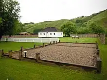
| Bitumount Site | near Fort McMurray Wood Buffalo Regional Municipality AB |
57°23′11″N 111°38′46″W / 57.3865°N 111.646°W | Alberta (4998) | 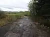 More images | |
| Grande Prairie High School | 10209 - 99 Street Grande Prairie AB |
55°10′23″N 118°47′28″W / 55.173°N 118.791°W | Alberta (5000) | 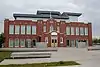 | |
| Cochrane Farm | RR 1 Grande Prairie County No. 1 AB |
55°14′07″N 118°38′20″W / 55.2354°N 118.639°W | Alberta (5003) | Q37777615 | Upload Photo |
| Athabasca United Church | 4817 - 48 Street Athabasca AB |
54°43′08″N 113°16′59″W / 54.719°N 113.283°W | Alberta (5178) | 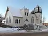 More images | |
| Canadian Northern Railway Station | 5101 - 50 Avenue Athabasca AB |
54°43′17″N 113°17′14″W / 54.7213°N 113.2873°W | Alberta (19043) | Q37777457 | Upload Photo |
| Melsness Mercantile Building | Valhalla Centre Grande Prairie County No. 1 AB |
55°24′13″N 119°22′59″W / 55.4036°N 119.383°W | Alberta (5185) | Q38528855 | Upload Photo |
| Monkman Homestead | near Cutbank Lake Grande Prairie County No. 1 AB |
55°15′28″N 119°07′55″W / 55.2577°N 119.132°W | Alberta (5186) | Q38529053 | Upload Photo |
| Hudson's Bay Company Factor's House | Fort Vermilion Mackenzie County AB |
58°23′48″N 116°00′07″W / 58.3966°N 116.002°W | Alberta (5723) | .JPG.webp) | |
| Obadiah Place | Amber Valley Athabasca County AB |
54°43′26″N 112°55′44″W / 54.7238°N 112.929°W | Alberta (5914) | Q38529302 | Upload Photo |
| Sexsmith Blacksmith Shop | Sexsmith AB |
55°20′59″N 118°47′01″W / 55.3497°N 118.7835°W | Alberta (6562) | 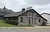 | |
| Northern Alberta Railway Station | Main Street and Railway Avenue Sexsmith AB |
55°20′58″N 118°47′10″W / 55.3495°N 118.786°W | Alberta (6852) |  | |
| Fort Dunvegan National Historic Site of Canada | west of Dunvegan Fairview Municipal District No. 136 AB |
55°55′25″N 118°36′14″W / 55.9235°N 118.604°W | Federal (18983), Alberta (8769) |
 | |
| Plavin Homestead | near North Star Northern Lights County AB |
56°50′23″N 117°36′58″W / 56.8397°N 117.616°W | Alberta (8991) | Upload Photo | |
| 1880 Anglican Church of St. Paul the Apostle and the 1874 Day School | Fort Chipewyan Wood Buffalo Regional Municipality AB |
58°42′33″N 111°06′58″W / 58.7093°N 111.116°W | Alberta (9088) | Upload Photo | |
| St. Bernard Mission (Church and Cemetery) | Grouard Big Lakes County AB |
55°32′41″N 116°09′29″W / 55.5447°N 116.158°W | Alberta (9089) | Upload Photo | |
| McNaught Homestead | south of Beaverlodge Grande Prairie County No. 1 AB |
55°09′07″N 119°26′13″W / 55.152°N 119.437°W | Alberta (9090) | Upload Photo | |
| Beaver River Quarry Archaeological Site | Near Fort MacKay Wood Buffalo Regional Municipality AB |
Alberta (10935) | Upload Photo | ||
| Quarry of the Ancestors | 6 miles northeast of Fort MacKay Wood Buffalo Regional Municipality AB |
57°11′53″N 111°31′56″W / 57.1981°N 111.5322°W | Alberta (18869) | Upload Photo | |
| Notre Dame des Victoires / Lac La Biche Mission National Historic Site of Canada | northwest of Lac La Biche Lac La Biche County AB |
54°49′22″N 112°05′38″W / 54.8227°N 112.0938°W | Federal (15064, (21497), Alberta (11122) |
More images | |
| Peace River N.A.R. Station | 9409 - 100 Street Peace River AB |
56°14′22″N 117°17′35″W / 56.2394°N 117.293°W | Alberta (11390) | Q38529616 | 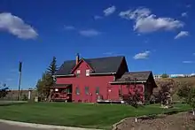 More images |
| Trapper's Shack | 5003 River Road, Fort Vermilion Mackenzie County AB |
58°14′03″N 116°00′36″W / 58.2342°N 116.01°W | Mackenzie County municipality (11482) | Upload Photo | |
| Eaglenest Portage Site | Near Fort MacKay Wood Buffalo Regional Municipality AB |
Alberta (11517) | Upload Photo | ||
| St. Augustine's Roman Catholic Mission | Shaftesbury Settlement Peace Municipal District No. 135 AB |
56°09′18″N 117°26′42″W / 56.155°N 117.445°W | Alberta (11611) | Q38530383 | More images |
| Bad Heart Straw Church | Teepee Creek Grande Prairie County No. 1 AB |
55°29′06″N 118°17′17″W / 55.485°N 118.288°W | Alberta (11819) | Upload Photo | |
| Battle River Hospital | 300 Main Street Manning AB |
56°55′22″N 117°37′52″W / 56.9229°N 117.631°W | Alberta (11821) | Upload Photo | |
| Fort Chipewyan III | Fort Chipewyan Wood Buffalo Regional Municipality AB |
58°42′44″N 111°08′56″W / 58.7123°N 111.149°W | Federal (17705), Alberta (11935) |
Q18534258 | .jpg.webp) More images |
| Fort Vermilion National Historic Site of Canada | Southeast corner of River Road and 45th Street, Fort Vermilion Mackenzie County AB |
58°23′02″N 116°02′24″W / 58.384°N 116.04°W | Federal (16741) |  More images | |
| Fort Fork National Historic Site of Canada | River Lot 19, Shaftesbury Settlement Peace Municipal District No. 135 AB |
56°08′11″N 117°28′01″W / 56.1364°N 117.467°W | Federal (17661) | Q5471152 | 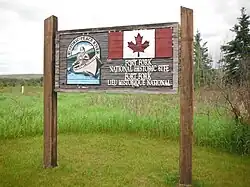 More images |
| Frog Lake National Historic Site of Canada | South of Frog Lake Frog Lake AB |
53°49′52″N 110°21′31″W / 53.8312°N 110.3587°W | Federal (18201) | 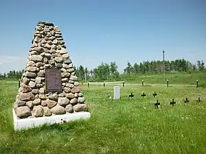 | |
| All Saints Anglican Church | Alberta Highway 717, Cherry Point Clear Hills County AB |
56°11′18″N 119°56′20″W / 56.1883°N 119.939°W | Clear Hills County municipality (17901) | Q33212259 | Upload Photo |
References
This article is issued from Wikipedia. The text is licensed under Creative Commons - Attribution - Sharealike. Additional terms may apply for the media files.