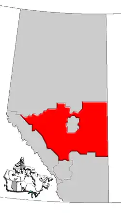
This article is a list of historic places in Central Alberta entered on the Canadian Register of Historic Places, whether they are federal, provincial, or municipal.
List
| Name | Address | Coordinates | Government recognition (CRHP №) | Image | |
|---|---|---|---|---|---|
| Sunnyslope Sandstone Shelter | Alongside Township Road 314 in Kneehill County, approximately 24 km west of Three Hills Didsbury AB |
51°40′24″N 113°37′02″W / 51.6732°N 113.6172°W | Alberta (18051) |  Upload Photo | |
| Delburne Alberta Government Telephones Exchange Building | 2030 - 22 Avenue Delburne AB |
52°11′55″N 113°14′03″W / 52.1987°N 113.2342°W | Delburne municipality (18843) | Upload Photo | |
| Cronquist House | 4707 Fountain Drive, Bower Ponds, Great Chief Park Red Deer AB |
52°16′11″N 113°49′55″W / 52.2696°N 113.832°W | Red Deer municipality (1649) | Upload Photo | |
| Canadian Pacific Railroad Bridge | Red Deer AB |
52°16′33″N 113°49′01″W / 52.2757°N 113.817°W | Red Deer municipality (1651) | Upload Photo | |
| Clark Residence, The | 4757 – 56 Street Red Deer AB |
52°16′30″N 113°48′32″W / 52.2751°N 113.809°W | Red Deer municipality (1652) | Upload Photo | |
| Allen Bungalow | 6316 - 45 Avenue Red Deer AB |
52°17′07″N 113°47′46″W / 52.2853°N 113.796°W | Red Deer municipality (1656) | Upload Photo | |
| Parsons Residence | 4801 - 49 Street Red Deer AB |
52°16′05″N 113°48′32″W / 52.268°N 113.809°W | Red Deer municipality (1658) | Upload Photo | |
| Old Red Deer Court House | 4836 Ross Street Red Deer AB |
52°16′09″N 113°48′40″W / 52.2693°N 113.811°W | Alberta (3445), Red Deer municipality (1663) |
Upload Photo | |
| Government of Canada Building | 4904 Ross Street Red Deer AB |
52°16′08″N 113°48′43″W / 52.268955°N 113.811821°W | Federal (4380) | Upload Photo | |
| Red Deer Armoury / Fire Hall #1 | 4905 - 49 Street Red Deer AB |
52°16′06″N 113°48′32″W / 52.2683°N 113.809°W | Red Deer municipality (1665) | Upload Photo | |
| Russo Greek Orthodox Church | Smoky Lake County AB |
54°02′35″N 112°08′02″W / 54.0431°N 112.134°W | Alberta (1818) | 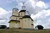 More images | |
| Senior Non Commissioned Officer's Building B-30 | Cold Lake AB |
54°24′47″N 110°16′26″W / 54.413°N 110.274°W | Federal (2839) | Upload Photo | |
| Flat Iron Building | 5005 - 50 Avenue Lacombe AB |
52°27′47″N 113°43′52″W / 52.463°N 113.731°W | Alberta (3032) | Upload Photo | |
| Ukrainian Pioneer Home | Sandy Beach AB |
53°40′36″N 112°49′43″W / 53.67667°N 112.82861°W | Federal (3089) | Q24012602 | .jpg.webp) More images |
| Alberta Pacific Grain Elevator Site Complex | Railway Avenue at Main Street, Meeting Creek Camrose County AB |
52°40′59″N 112°43′59″W / 52.683°N 112.733°W | Alberta (3190) | Upload Photo | |
| Hangar 1 | 4 Wing Cold Lake Cold Lake AB |
54°24′22″N 110°16′41″W / 54.4062°N 110.278°W | Federal (3357) | Upload Photo | |
| Hangar 2 | 4 Wing Cold Lake Cold Lake AB |
54°24′47″N 110°16′26″W / 54.413°N 110.274°W | Federal (3358) | Upload Photo | |
| Hangar 3 | 4 Wing Cold Lake Cold Lake AB |
54°24′47″N 110°16′27″W / 54.413°N 110.2742°W | Federal (2001) | Upload Photo | |
| Hangar 4 | 4 Wing Cold Lake Cold Lake AB |
54°24′47″N 110°16′27″W / 54.413°N 110.2743°W | Federal (3365) | Upload Photo | |
| Hangar 6 | 4 Wing Cold Lake Cold Lake AB |
54°24′47″N 110°16′28″W / 54.413°N 110.2745°W | Federal (9476) | Upload Photo | |
| Superintendent's Residence | near Elk Island National Park West Gate AB |
53°41′5″N 112°52′0″W / 53.68472°N 112.86667°W | Federal (3561) | Q24012859 | .jpg.webp) More images |
| Barn | near Elk Island National Park Visitor Center Elk Island National Park AB |
53°34′45″N 112°50′07″W / 53.579302°N 112.835223°W | Federal (4427) | Upload Photo | |
| Pavilion | Sandy Beach AB |
53°40′43″N 112°49′50″W / 53.67861°N 112.83056°W | Federal (3562) | Q23937541 | .jpg.webp) More images |
| Normal School / Rosehaven | 4612 53rd Street | 53°0′55″N 112°49′59″W / 53.01528°N 112.83306°W | Alberta (5005) | Q24284741 | 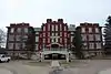 More images |
| Roland Michener House | 5036 - 51 Street Lacombe AB |
52°27′51″N 113°43′55″W / 52.4643°N 113.732°W | Alberta (5006) |  | |
| St. Edmund's Anglican Church | 52°2′15″N 112°45′11″W / 52.03750°N 112.75306°W | Alberta (5007) | Q24039796 | 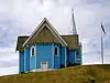 More images | |
| Ukrainian Greek Orthodox Church of St. Mary (Szypentiz district) | east of Hairy Hill AB |
53°46′17.321″N 111°51′16.826″W / 53.77147806°N 111.85467389°W | Alberta (5063) | Q7878462 | Upload Photo |
| Alberta Pacific Grain Elevator | 49 Avenue Castor AB |
52°13′01″N 111°54′14″W / 52.2169°N 111.904°W | Alberta (5099) |  More images | |
| Camrose Feed Mill | 4919 47th Street | 53°1′18″N 112°49′12″W / 53.02167°N 112.82000°W | Alberta (5102) | Q24284733 | 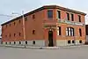 More images |
| Krause Milling Company Grain Elevator and Flour Mill Site Complex | First Street East and Railway Avenue, Radway Thorhild County AB |
54°03′37″N 112°56′31″W / 54.0602°N 112.942°W | Alberta (5106) | Upload Photo | |
| Camrose Public Library | 4859 50th Street | 53°1′12″N 112°49′30″W / 53.02000°N 112.82500°W | Alberta (5135) | Q24284731 |  More images |
| Catholic Church of St. Thomas | north of Duhamel Camrose County AB |
52°56′37″N 112°56′31″W / 52.9437°N 112.942°W | Alberta (5136) | Upload Photo | |
| St. Norbert's Roman Catholic Church | southeast of Provost Provost Municipal District No. 52 AB |
52°15′35″N 110°10′16″W / 52.2597°N 110.171°W | Alberta (5148) | Upload Photo | |
| Battle River Lutheran Church | near Chauvin Wainwright Municipal District No. 61 AB |
52°52′21″N 110°11′06″W / 52.8725°N 110.185°W | Wainwright Municipal District No. 61 municipality (5174) | Upload Photo | |
| Fort Ethier | 53°1′43″N 113°24′43″W / 53.02861°N 113.41194°W | Alberta (5180) | Q24038549 |  More images | |
| Wetaskiwin Court House | 4705 50th Avenue | 52°58′7″N 113°22′0″W / 52.96861°N 113.36667°W | Federal (7552), Alberta (5188) |
Q23706048 | _02.JPG.webp) More images |
| Canadian Bank of Commerce Building | 5204 - 50 Avenue Innisfree AB |
53°22′53″N 111°31′48″W / 53.3815°N 111.53°W | Alberta (5215) | Upload Photo | |
| Verdun School | near New Norway Camrose County AB |
52°55′51″N 113°05′17″W / 52.9309°N 113.088°W | Alberta (5216) | Upload Photo | |
| Greenridge Farm | north of Dewberry Vermilion River AB |
53°40′29″N 110°29′46″W / 53.6746°N 110.496°W | Alberta (5347) | Upload Photo | |
| Hiebert Residence | 2102 24th Avenue AB |
51°39′53.122″N 114°8′24.317″W / 51.66475611°N 114.14008806°W | Alberta (5738) | Q37778160 |  More images |
| Dr. Henry George Residence | 5711 - 13 51 Avenue Innisfail AB |
52°01′54″N 113°57′14″W / 52.0316°N 113.954°W | Alberta (5739) |  | |
| Canadian Northern Station Building and Roundhouse Site Complex | Railway Ave. Big Valley AB |
52°01′58″N 112°44′56″W / 52.032715°N 112.749000°W | Alberta (5001) |  | |
| C. N. R. Station and Water Tower | Heinsburg AB |
53°46′06″N 110°31′31″W / 53.768320°N 110.525220°W | Alberta (5002) | Upload Photo | |
| Alberta Wheat Pool Grain Elevator Site Complex | Andrew AB |
53°52′38″N 112°20′19″W / 53.877293°N 112.338748°W | Alberta (5100) | Upload Photo | |
| Canadian Pacific Railway Station | Railway Street Didsbury AB |
51°39′30.640″N 114°8′14.165″W / 51.65851111°N 114.13726806°W | Alberta (5740) | Q37777536 |  More images |
| Canadian Pacific Railway Station | 700 1st Avenue Beiseker AB |
51°23′07″N 113°32′18″W / 51.385292°N 113.538390°W | Beiseker municipality (8770) | .jpg.webp) | |
| Canadian Northern Railway Station | Railway Dr. Smoky Lake AB |
54°06′46″N 112°28′16″W / 54.112676°N 112.471132°W | Alberta (6855) | Upload Photo | |
| Canadian Northern Railway Station | 4407 - 47 Avenue Camrose AB |
53°00′56″N 112°48′56″W / 53.015551°N 112.815510°W | Alberta (7759) | Upload Photo | |
| Canadian Northern Railway Station | Railway Avenue Meeting Creek AB |
52°40′53″N 112°43′43″W / 52.681388°N 112.728636°W | Alberta (8768) | Upload Photo | |
| Canadian National Railway Station | 4922 - 52 Avenue Vegreville AB |
53°29′46″N 112°02′59″W / 53.496009°N 112.049825°W | Alberta (7422) | Upload Photo | |
| St. Mary'S Roumanian Orthodox Church of Boian | 53°49′45″N 112°0′18″W / 53.82917°N 112.00500°W | Alberta (5758) | Q24025035 | Upload Photo | |
| River Lot 3 | 54°0′29″N 112°23′38″W / 54.00806°N 112.39389°W | Alberta (5759) | Q24042166 | Upload Photo | |
| Coronation Boundary Marker | Coronation Paintearth County No. 18 AB |
51°58′08″N 111°25′59″W / 51.9689°N 111.433°W | Alberta (5889) | Upload Photo | |
| Stephan G. Stephansson House | Twp Road 371, west of Range Road 22 | 52°9′34.9″N 114°12′3.6″W / 52.159694°N 114.201000°W | Alberta (5892) | Q34118715 |  More images |
| Alberta Hospital Building No. 1 | south of Ponoka Ponoka County AB |
52°39′03″N 113°34′26″W / 52.6507°N 113.574°W | Alberta (5894) | Upload Photo | |
| Former Calgary and Edmonton Railway Station | 5102 Ross St. (or 50th St.) CPR Right of Way Red Deer AB |
52°16′05″N 113°48′58″W / 52.268°N 113.816°W | Federal (6471), Alberta (2894), Red Deer municipality (1719) |
Upload Photo | |
| Dickson Store and Site | Dickson Red Deer County AB |
52°03′27″N 114°18′40″W / 52.0574°N 114.311°W | Alberta (6557) | Upload Photo | |
| Old St. Paul Rectory | St. Paul AB |
53°59′25″N 111°17′17″W / 53.9904°N 111.288°W | Alberta (6561) | Upload Photo | |
| Lamont United Church | 5102 - 53 Street Lamont AB |
53°45′40″N 112°47′17″W / 53.761°N 112.788°W | Lamont municipality (7433) | Upload Photo | |
| Victoria Settlement | 54°0′13.82″N 112°23′53.16″W / 54.0038389°N 112.3981000°W | Federal (7744) | Q5472219 |  More images | |
| Rocky Mountain House trading post | Hwy. 11A, west of Rocky Mountain House AB |
52°21′59″N 114°57′48″W / 52.36639°N 114.96333°W | Federal (7827) | Q23706052 |  More images |
| Nativity of the Holy Virgin Orthodox Church of Kysylew | north of Andrew Lamont County AB |
53°54′53″N 112°21′29″W / 53.9146°N 112.358°W | Lamont County municipality (7917) | Upload Photo | |
| Ukrainian Catholic Church of Spasa (Muskalik) | east of Mundare on Range Road 160 Lamont County AB |
53°37′27″N 112°12′50″W / 53.6242°N 112.214°W | Lamont County municipality (7918) | Upload Photo | |
| Russo-Orthodox Church of the Transfiguration (Star Edna) | north of Lamont Lamont County AB |
53°51′45″N 112°43′44″W / 53.8624°N 112.729°W | Lamont County municipality (7919) | Upload Photo | |
| St. Nicholas Ukrainian Catholic Church of St. Michael And Bell Tower | southeast of St. Michael Lamont County AB |
53°48′08″N 112°34′26″W / 53.8022°N 112.574°W | Lamont County municipality (7920) | Upload Photo | |
| Presentation of the Blessed Virgin Mary Ukrainian Catholic Church (Delph) | north of Lamont Lamont County AB |
54°00′53″N 112°40′37″W / 54.0148°N 112.677°W | Lamont County municipality (7921) | Upload Photo | |
| Nativity of the Blessed Virgin Mary Ukrainian Greek Catholic Church | north of Lamont Lamont County AB |
53°59′56″N 112°49′41″W / 53.999°N 112.828°W | Lamont County municipality (7924) | Upload Photo | |
| Sharman House | RR #3, near Onoway Lac Ste. Anne County AB |
53°39′38″N 114°12′43″W / 53.6606°N 114.212°W | Alberta (7983) | Upload Photo | |
| Diplomat Mine Site | southwest of Forestburg Flagstaff County AB |
52°30′20″N 112°11′28″W / 52.5055°N 112.191°W | Alberta (7985) | Upload Photo | |
| Urquhart Block | 4923 - 50 Avenue Lacombe AB |
52°27′47″N 113°43′48″W / 52.463°N 113.73°W | Alberta (8252) | Upload Photo | |
| Markerville Creamery | 114 Creamery Way | 52°7′25.0″N 114°10′19.2″W / 52.123611°N 114.172000°W | Alberta (8453) | Q34120180 | Upload Photo |
| M and J Hardware Building | 4910 to 4912 - 50 Avenue Lacombe AB |
52°27′48″N 113°43′48″W / 52.4632°N 113.73°W | Alberta (8753) | Upload Photo | |
| Newbrook Observatory | Newbrook Thorhild County AB |
54°19′28″N 112°57′18″W / 54.3245°N 112.955°W | Alberta (8809) | Upload Photo | |
| George Pegg Homestead And Botanic Garden | near Glenevis Lac Ste. Anne County AB |
53°48′30″N 114°31′08″W / 53.8082°N 114.519°W | Alberta (8812) | Upload Photo | |
| Horse Barn, Building 1 | Sundre Clearwater County AB |
51°44′15″N 115°35′46″W / 51.7375°N 115.596°W | Federal (9602) | Upload Photo | |
| Lac Ste. Anne Pilgrimage site | 53°42′N 114°24′W / 53.700°N 114.400°W | Federal (9618) | Q6467888 |  More images | |
| Alberta Wheat Pool Grain Elevator (Paradise Valley) | Paradise Valley AB |
Alberta (10403) | .jpg.webp) More images | ||
| Alberta Wheat Pool Grain Elevator | 4715 - 52 Avenue Mayerthorpe AB |
53°57′19″N 115°08′05″W / 53.955326°N 115.134673°W | Alberta (8038) | Upload Photo | |
| Canadian Pacific Railway Station | Paradise Valley AB |
53°01′49″N 110°17′46″W / 53.0304°N 110.296°W | Alberta (10457) | Upload Photo | |
| The Bailey Theatre | 5041 50th Street | 53°1′24″N 112°49′30″W / 53.02333°N 112.82500°W | Camrose municipality (10818) | Q24284729 | _1.jpg.webp) More images |
| Wainwright Hotel | 202 - 10 Street Wainwright AB |
52°50′02″N 110°51′40″W / 52.8339°N 110.861°W | Alberta (11129) | Upload Photo | |
| Whitecourt / Woodlands Meteorite Impact Crater | near Whitecourt Woodlands County AB |
Alberta (11389) | Upload Photo | ||
| Baptiste River Metis Settlement Site | confluence of Baptiste River and North Saskatchewan River Clearwater County AB |
Alberta (11557) | Upload Photo | ||
| Buffalo Lake Metis Settlement | between Buffalo Lake and Lynn Lake, near Stettler Stettler County No. 6 AB |
Alberta (11558) | Upload Photo | ||
| Fort De L'Isle | northeast of Myrnam AB |
53°45′11″N 111°10′34″W / 53.75306°N 111.17611°W | Alberta (11562) | Q5472471 | Upload Photo |
| Fort White Earth | west of confluence of White Earth Creek and North Saskatchewan River Smoky Lake County AB |
Alberta (11576) | Upload Photo | ||
| Fort Vermilion | Lea Park, north of Marwayne Vermilion River County AB |
Alberta (11577) | Upload Photo | ||
| Bashaw Fire Hall | 5018 50th Street | 52°35′3″N 112°58′16″W / 52.58417°N 112.97111°W | Alberta (11818) | Q24279158 | Upload Photo |
| Brazeau Collieries Minesite | Nordegg AB |
52°28′14″N 116°4′31″W / 52.47056°N 116.07528°W | Federal (12009), Alberta (15529) |
Q23706045 |  More images |
| Vilna Pool Hall and Barbershop | 5028 - 50 Street Vilna AB |
54°06′58″N 111°55′16″W / 54.1162°N 111.921°W | Alberta (12410) | 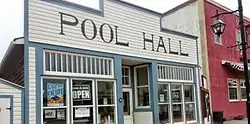 More images | |
| Campbell Block | 4922 and 4918 - 50 Avenue Lacombe AB |
52°27′48″N 113°43′48″W / 52.4632°N 113.73°W | Alberta (12411) | Upload Photo | |
| MacKenzie School | Building 83, Hickory Street Cold Lake AB |
54°25′04″N 110°15′50″W / 54.4179°N 110.264°W | Federal (13079) | Upload Photo | |
| École Voyageur | Building 82, Birch Avenue Cold Lake AB |
54°25′04″N 110°15′50″W / 54.4179°N 110.264°W | Federal (13083) | Upload Photo | |
| Holy Trinity Anglican Church | southeast of Red Deer Red Deer County AB |
52°06′33″N 113°28′54″W / 52.109251°N 113.481790°W | Red Deer County municipality (13353) | Upload Photo | |
| Markerville Lutheran Church | 66 Johnson Avenue | 52°7′28.9″N 114°10′12.0″W / 52.124694°N 114.170000°W | Alberta (18804), Red Deer County municipality (13354) |
Q34121041 | 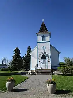 More images |
| Our Lady of the Rosary Hospital | 5406 - 47 Street Castor AB |
52°13′26″N 111°54′29″W / 52.2238°N 111.908°W | Alberta (15687) | Upload Photo | |
| Alberta Government Telephones Exchange Building | 5041 A - 50 Street Mannville AB |
53°20′20″N 111°10′44″W / 53.3389°N 111.179°W | Alberta (15695) | Upload Photo | |
| Donalda Creamery | Foster Street Donalda AB |
52°35′10″N 112°34′34″W / 52.5861°N 112.576°W | Alberta (16522) | Upload Photo | |
| Fort Assiniboine | 54°20′2″N 114°46′27″W / 54.33389°N 114.77417°W | Federal (17704) | Q18534260 | Upload Photo | |
| Village Tresures | 5009-50th Street Mannville AB |
53°20′15″N 111°10′44″W / 53.3375°N 111.179°W | Mannville municipality (17905) | Upload Photo | |
| St. Monica's Anglican Church | 4910 - 53 Street, Mirror Lacombe County AB |
52°27′53″N 113°06′40″W / 52.4646°N 113.111°W | Lacombe County municipality (17945) | Upload Photo | |
| St. Laurence Anglican Church | Monitor Special Area No. 4 AB |
51°58′43″N 110°34′08″W / 51.9786°N 110.569°W | Special Area No. 4 municipality (17946) | Upload Photo | |
| Beatty Heritage House | 5002 - 51 Street Rimbey AB |
52°38′24″N 114°14′31″W / 52.6399°N 114.242°W | Alberta (18321), Rimbey municipality (3189) |
Upload Photo | |
| Northern Defence Radar Station | near Cold Lake AB |
54°26′6″N 110°10′55″W / 54.43500°N 110.18194°W | Alberta (18390) | Q24279148 | Upload Photo |
| Red Brick School | 2118 21st Avenue | 51°39′43.621″N 114°8′26.826″W / 51.66211694°N 114.14078500°W | Alberta (18593) | Q38529880 | 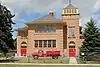 More images |
| Lacombe Blacksmith Shop | 5020 - 49 Street Lacombe AB |
Alberta (18865) |  | ||
| McDonald Stopping House | Township Road 585A at Range Road 182, southeast of Waskatenau Waskatenau AB |
54°03′22″N 112°43′40″W / 54.0562°N 112.7277°W | Alberta (18805) | Upload Photo | |
| Parkland Evangelical Lutheran Church | Province Route 26 east of Range Road 184, east of Ohaton Ohaton AB |
53°01′05″N 112°34′51″W / 53.0180°N 112.5807°W | Alberta (17821) | Upload Photo | |
| Community Rest Room | 5014 - 51 Avenue Ponoka AB |
52°40′38″N 113°34′36″W / 52.6771°N 113.5766°W | Alberta (18826) | Upload Photo | |
| Merchants Bank of Canada Building | 4813 - 47 Street Sedgewick AB |
52°46′27″N 111°41′32″W / 52.7741°N 111.6923°W | Alberta (13577) | Upload Photo | |
| Strome Memorial Hall | 50 Street Strome AB |
52°48′43″N 112°03′58″W / 52.812°N 112.0660°W | Alberta (18825) | .jpg.webp) |
See also
This article is issued from Wikipedia. The text is licensed under Creative Commons - Attribution - Sharealike. Additional terms may apply for the media files.