The State Register of Heritage Places is maintained by the Heritage Council of Western Australia. As of 2023, 135 places are heritage-listed in the Town of Cambridge,[1] of which 14 are on the State Register of Heritage Places.[2]
List
The Western Australian State Register of Heritage Places, as of 2023, lists the following 14 state registered places within the Town of Cambridge:
| Place name | Place # | Street number | Street name | Suburb or town | Co-ordinates | Notes & former names | Photo |
|---|---|---|---|---|---|---|---|
| Leederville Town Hall & Recreation Complex | 2195 | 82-84 | Cambridge Street | West Leederville | 31°56′26″S 115°50′12″E / 31.940517°S 115.836635°E |  | |
| West Leederville Primary School | 2208 | 58 | Northwood Street | West Leederville | 31°56′21″S 115°49′58″E / 31.939118°S 115.832701°E | ||
| Catherine McAuley Centre | 2231 | 18 | Barrett Street | Wembley | 31°56′22″S 115°49′24″E / 31.939314°S 115.823228°E | New Subiaco, Benedictine Monstery, St Vincents, Orphanage & Foundling Home, St Joseph's Orph |  |
| Model Brick Home | 8894 | 6 | The Boulevard | Floreat | 31°56′20″S 115°48′13″E / 31.9390°S 115.8036°E |  | |
| Model Timber Home | 8895 | 12 | The Boulevard | Floreat | 31°56′19″S 115°48′11″E / 31.9387°S 115.8031°E |  | |
| Quarry Amphitheatre, City Beach | 9102 | 145 | Oceanic Drive | City Beach | 31°56′22″S 115°46′39″E / 31.9395°S 115.7775°E |  | |
| City Beach and Floreat Beach Precinct | 9108 | Challenger Parade, between Oceanic Drive and The Boulevard | City Beach | 31°56′04″S 115°45′19″E / 31.9344°S 115.7554°E | City Beach, Groyne and Lookout Tower | 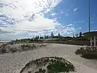 | |
| Holy Spirit Catholic Church, City Beach | 13020 | 2 | Keaney Place | City Beach | 31°55′00″S 115°45′53″E / 31.916735°S 115.764847°E | 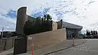 | |
| Benedictine Stables (former) | 23680 | 18 | Barrett Street | Wembley | 31°56′18″S 115°49′21″E / 31.938386°S 115.822567°E | Old Benedictine Monastery (part of early development of the site), Stables - Catherine McAuley Centre | 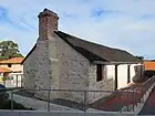 |
| St Vincent's Foundlings Home | 23830 | 18 | Barrett Street | Wembley | 31°56′18″S 115°49′26″E / 31.938331°S 115.823822°E |  | |
| Olive Trees, Barrett Street | 23834 | 18 | Barrett Street | Wembley | 31°56′19″S 115°49′23″E / 31.938623°S 115.823124°E | Olea europaea | %252C_Barrett_Street%252C_June_2023_01.jpg.webp) |
| Leederville War Memorial and Rose Garden | 23872 | 78-80 | Cambridge Street | West Leederville | 31°56′26″S 115°50′13″E / 31.940508°S 115.836956°E | 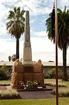 | |
| South City Beach Kiosk | 26251 | Challenger Parade | City Beach | 31°56′23″S 115°45′18″E / 31.9398°S 115.7549°E | Part of the City Beach and Floreat Beach Precinct (9108) | 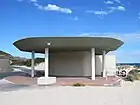 | |
| Bob Hawke's House (former) | 26464 | 101 | Tate Street | West Leederville | 31°56′14″S 115°49′43″E / 31.9373°S 115.8285°E | Childhood home of Australia's 23rd Prime Minister, Bob Hawke |
References
- ↑ "Town of Cambridge Heritage Places". inherit.stateheritage.wa.gov.au. Heritage Council of Western Australia. Retrieved 19 February 2023.
- ↑ "Town of Cambridge State Register of Heritage Places". inherit.stateheritage.wa.gov.au. Heritage Council of Western Australia. Retrieved 19 February 2023.
This article is issued from Wikipedia. The text is licensed under Creative Commons - Attribution - Sharealike. Additional terms may apply for the media files.