The State Register of Heritage Places is maintained by the Heritage Council of Western Australia. As of 2023, 74 places are heritage-listed in the Shire of Plantagenet,[1] of which six are on the State Register of Heritage Places.[2]
List
State Register of Heritage Places
The Western Australian State Register of Heritage Places, as of 2023, lists the following six state registered places within the Shire of Plantagenet:
| Place name | Place # | Street number | Street name | Suburb or town | Co-ordinates | Notes & former names | Photo |
|---|---|---|---|---|---|---|---|
| Hassell Homestead | 2262 | Corner Albany Highway & Jellicoe Road | Kendenup | 34°30′24″S 117°35′50″E / 34.506602°S 117.597235°E | Kalgan Hall, Kendenup / Keninup Homestead |  | |
| Police Station and Gaol Complex (former) | 2268 | Albany Highway | Mount Barker | 34°37′05″S 117°39′37″E / 34.618117°S 117.660167°E | 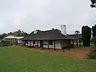 | ||
| St Werburgh's Chapel and Cemetery | 2284 | Chapel Road | Mount Barker | 34°41′07″S 117°35′59″E / 34.6852°S 117.599827°E | St Werbergh's Chapel |  | |
| Mount Barker Railway Station (former) | 2318 | Lowood Road | Mount Barker | 34°37′41″S 117°39′50″E / 34.627924°S 117.663806°E | .jpg.webp) | ||
| St Werburgh's Farm Buildings | 10996 | St Werburghs Road | Mount Barker | 34°41′16″S 117°35′44″E / 34.687668°S 117.595466°E |  | ||
| Round House, Mount Barker | 16781 | 31712 | Albany Highway | Mount Barker | 34°36′55″S 117°39′35″E / 34.615148°S 117.659785°E |  |
Shire of Plantagenet heritage-listed places
The following places are heritage listed in the Shire of Plantagenet but are not State registered:
| Place name | Place # | Street number | Street name | Suburb or town | Notes & former names | Photo |
|---|---|---|---|---|---|---|
| Narrikup Hall | 2259 | Narrikup, 15 km South of Mount Barker |  | |||
| Forest Hill Agricultural Hall | 2260 | Forest Hill | ||||
| Kendenup Hall | 2261 | Corner | Beverley Street & Hassell Avenue | Kendenup |  | |
| Shepherd's Store | 2263 | Hassell Avenue | Kendenup | |||
| Mining Battery (former) | 2264 | Jellicoe Road | Kendenup | Five Stamp Battery |  | |
| Primary School | 2265 | Austin Street | Kendenup | Kendenup School |  | |
| District Hall | 2266 | Porongurup | ||||
| Mount Barker Police Station - Second | 2267 | Albany Highway | Mount Barker | Student Hostel |  | |
| Old Coach Inn (ruins) | 2269 | MacDonald Street | Mount Barker | Park Hotel (former), Old Bush Inn Hotel | ||
| Mount Barker Post Office (former) | 2270 | Corner | Albany Highway & Ormond Road | Mount Barker | Old Post Office/Arts Centre | |
| Mount Barker Primary School (former) | 2271 | 30 | Albany Highway | Mount Barker | Seventh Day Adventist Church | .jpg.webp) |
| Plantagenet District Hospital | 2272 | 47 | Langton Road | Mount Barker | ||
| Plantagenet District Hospital Nurses Quarters | 2273 | Langton Road | Mount Barker | |||
| Mount Barker Hotel (former) | 2274 | Corner | Langton & Lowood Roads | Mount Barker | The Top Pub | .jpg.webp) |
| ANZ Bank (former) | 2275 | 17 | Lowood Road | Mount Barker | Mt Barker Coffee Lounge | .jpg.webp) |
| Park Hotel (former) | 2276 | Corner | Lowood Road & Muir Street | Mount Barker | Plantagenet Hotel, Bottom Pub | .jpg.webp) |
| Bank of New South Wales & Quarters (NSW) (former) | 2277 | Corner | Lowood Road & Short Street | Mount Barker | Westpac Bank | .jpg.webp) |
| Mount Barker Court House and Police Station | 2279 | Mt Barker Street | Mount Barker | |||
| Police Quarters | 2280 | Mt Barker Street | Mount Barker | |||
| Plantagenet District Hall | 2281 | Corner | Albany Highway & Muir Street | Mount Barker | .jpg.webp) | |
| All Saints Anglican Church | 2282 | Corner | Albany Highway & Nunarrup Street | Mount Barker | .jpg.webp) | |
| Nonconformist Church (former) | 2283 | Corner | Albany Highway & Ormond Road | Mount Barker | Uniting Church Meeting Place | |
| Abbeyholme | 3295 | 40 | Mitchell Streetreet | Mount Barker | James Sounness's House | |
| Railway House | 3383 | 11 | Albany Highway | Mount Barker | Westrail House, Old Mount Barker Station House | |
| Old Hay River Bridge | 3517 | St Werburghs Road | Mount Barker | |||
| Bakehouse (former), Kendenup | 4000 | 55 | Hassell Avenue | Kendenup | ||
| Mt Barker War Memorial & RSL Memorial Park | 5544 | Muir Street | Mount Barker | |||
| Avoca | 10978 | Albany Highway | Mount Barker | |||
| Bolganup | 10979 | Porongurup Road | Porongurup | |||
| Jones Cottage | 10980 | Lowood Road | Mount Barker | |||
| Duckett's Building | 10981 | Langton Road | Mount Barker | |||
| First Hospital (Nursing Home) | 10982 | 60 | Langton Road | Mount Barker | Hospital/Doctor's Surgery, Private Residence | |
| Government Dam | 10983 | Corner | Lowood Road & McDonald Avenue | Mount Barker | ||
| Hay River Farm Cairn | 10984 | Spencer Road | Narrikup | |||
| Hicks Well | 10985 | Albany Highway | Mount Barker | |||
| Karribank Lodge | 10986 | Porongurup | ||||
| Langton | 10987 | Muirs Highway | Mount Barker | Goundrey Wines | ||
| Masonic Hall | 10988 | Muir Street | Mount Barker | |||
| Maud Scott's Greengrocers (former) | 10989 | Lowood Road | Mount Barker | Sue's Hardressing Salon, Mary Weiss' | ||
| Merryup | 10990 | Muirs Highway | Mount Barker | |||
| Narrikup Store | 10991 | Spencer Road | Narrikup | |||
| Ongerup | 10992 | Mount Barker | Ungerup | |||
| A M Pearse & Co Garage | 10993 | Lowood Road | Mount Barker | Garrity's Garage | ||
| Plantagenet Second Hospital | 10994 | 21 | Menston Street | Mount Barker | Plantagenet Hospital | |
| Frost Park | 10995 | MacDonald Avenue | Mount Barker | Showgrounds | ||
| The Rookery | 10997 | Albany Highway | Mount Barker | |||
| Reeves Tearoom & Fuel Depot | 10998 | Lowood Road | Mount Barker | Warrie's | ||
| Peerimbup (former) | 10999 | Albany Highway | Mount Barker | Williams Rest, Chateau Barker Winery | ||
| Woogenellup Bridge | 11001 | North Woogenilup Road | Woogenilup | |||
| St Werburgh's Homestead | 11074 | 66 | Goundrey Road | Mount Barker | Egerton-Warburton Homestead | 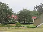 |
| New Kalgan River Road Bridge | 11721 | South Coast Highway | Kalgan | Upper Kalgan River bridge | ||
| Upper Kalgan River Road Bridge | 13073 | North Woogenilup Road | Woogenilup | Road Bridge, Kalgan River, MRWA 4324 | ||
| Mount Barker Fire Station | 14608 | Lowood Road | Mount Barker | |||
| Church | 15204 | Albany Highway | Mount Barker | |||
| Manse | 15205 | Ormond Road | Mount Barker | |||
| Waddy's Hut | 15467 | Wansbrough Walk | Porongurup National Park | |||
| Old Kalgan River Road Bridge | 16090 | old alignment of South Coast Highway | Kalgan | Upper Kalgan Bridge | ||
| Kalgan River Road Bridge | 16106 | Chesterpass Road | Stouth Stirling Range National Park | Upper Kalgan Road Bridge | ||
| Rocky Gully Primary School | 16242 | Lot 108 | Arbour Street | Rocky Gully | ||
| Mount Barker Primary School | 16302 | Oatlands Road | Mount Barker | |||
| Forest Hill and Moriarty-Camballup Trails | 16799 | |||||
| Mount Barker Fruit Inspection & Dehydration Shed (former) | 17587 | Lowood Road | Mount Barker | Mount Barker Fruit Growers' Cool Storage Co-o, Fruit Packing Shed, Railway Goods Shed | ||
| Porongurup National Park | 18716 | Mt Barker Porongurup Road | Woodlands via Mount Barker | _walkway.jpg.webp) | ||
| Pre-school, 8 Ormond St, Mt Barker | 24706 | 8 | Ormond Street | Mount Barker | Cooinda Aboriginal Pre-school | |
| Manurup Block (Mt Barker Research Station) | 25140 | Eulap-Manurup Road | Mount Barker | |||
| Mount Barker Research Station | 25142 | 7107 | Eulup-Manurup Road | Mount Barker | ||
| Hay River Road Bridge, Pardelup | 25525 | Plantagenet | MRWA Bridge 502 | |||
| Bridge 500, Muir Highway over Kent River, Perillup | 26304 | Muirs Highway | Kenton |
References
- ↑ "Shire of Plantagenet Heritage Places". inherit.stateheritage.wa.gov.au. Heritage Council of Western Australia. Retrieved 20 February 2023.
- ↑ "Shire of Plantagenet State Register of Heritage Places". inherit.stateheritage.wa.gov.au. Heritage Council of Western Australia. Retrieved 20 February 2023.
This article is issued from Wikipedia. The text is licensed under Creative Commons - Attribution - Sharealike. Additional terms may apply for the media files.