There are over 9,000 Grade I listed buildings and 20,000 Grade II* listed buildings in England. This page is a list of these buildings in the London Borough of Hammersmith and Fulham.
Grade I
| Name | Location | Type | Completed [note 1] | Date designated | Grid ref.[note 2] Geo-coordinates |
Entry number [note 3] | Image |
|---|---|---|---|---|---|---|---|
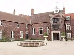
| Fulham Palace | Hammersmith and Fulham | Bishops Palace | c. 1480 | 7 May 1954 | TQ2400576117 51°28′14″N 0°12′58″W / 51.47044°N 0.216046°W |
1286903 |
Grade II*
| Name | Location | Type | Completed [note 1] | Date designated | Grid ref.[note 2] Geo-coordinates |
Entry number [note 3] | Image |
|---|---|---|---|---|---|---|---|
| Church of Holy Trinity, Brook Green W6 | Hammersmith and Fulham | Roman Catholic Church | 1851 | 14 February 1985 | TQ2388378812 51°29′41″N 0°13′01″W / 51.494687°N 0.216857°W |
1079845 | 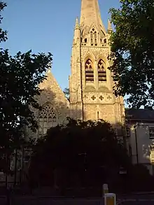 Church of Holy Trinity, Brook Green W6 |
| Church of St John the Evangelist, Glenthorne Road W6 | Hammersmith and Fulham | Former church | 1857-9 | 17 June 1954 | TQ2297578790 51°29′41″N 0°13′48″W / 51.494687°N 0.229938°W |
1286817 | 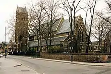 Church of St John the Evangelist, Glenthorne Road W6 |
| Church of St Paul, Queen Caroline Street, Hammersmith W6 | Hammersmith, Hammersmith and Fulham | Church | 1882–91 | 17 June 1954 | TQ2330078444 51°29′29″N 0°13′31″W / 51.491507°N 0.22538°W |
1079802 | 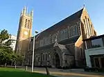 Church of St Paul, Queen Caroline Street, Hammersmith W6 |
| St Peter's Church, Hammersmith, Black Lion Lane W6 | Hammersmith and Fulham | Church | 1827 | 17 June 1954 | TQ2215578399 51°29′29″N 0°14′31″W / 51.491351°N 0.241879°W |
1079843 |  St Peter's Church, Hammersmith, Black Lion Lane W6 |
| Church of St Thomas of Canterbury, Rylston Road SW6 | Hammersmith and Fulham | Church | 1847-9 | 12 May 1970 | TQ2467477386 51°28′54″N 0°12′21″W / 51.481697°N 0.205972°W |
1358590 | 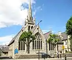 Church of St Thomas of Canterbury, Rylston Road SW6 |
| Church of the Holy Innocents, Paddenswick Road W6 | Hammersmith and Fulham | Church | 1890–98 | 17 June 1954 | TQ2260179070 51°29′50″N 0°14′07″W / 51.497285°N 0.235226°W |
1192523 | .jpg.webp) Church of the Holy Innocents, Paddenswick Road W6 |
| Convent and School of the Sacred Heart, 212 Hammersmith Road W6 | Hammersmith and Fulham | House | 1899–1900 | 17 June 1954 | TQ2343578678 51°29′37″N 0°13′24″W / 51.49358°N 0.223354°W |
1192062 | .JPG.webp) Convent and School of the Sacred Heart, 212 Hammersmith Road W6 |
| Cremorne Bridge, West London Extension Railway Bridge | Hammersmith and Fulham | Railway Bridge | 1863 | 26 November 2008 | TQ2650776503 51°28′24″N 0°10′48″W / 51.473355°N 0.179905°W |
1393006 | 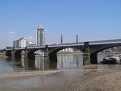 Cremorne Bridge, West London Extension Railway Bridge |
| Hammersmith Odeon, former cinema, now concert venue | Hammersmith and Fulham | Cinema | 1932 | 26 March 1990 | TQ2336678361 51°29′27″N 0°13′28″W / 51.490746°N 0.224458°W |
1252993 |  Hammersmith Odeon, former cinema, now concert venue |
| Fulham Town Hall (original Building and 1904-5 Extension) | Fulham Road, Fulham SW6 | Town Hall | Built 1888–1890 | 31 July 1981 | TQ2545877187 51°28′47″N 0°11′41″W / 51.479736°N 0.194758°W |
1191939 | 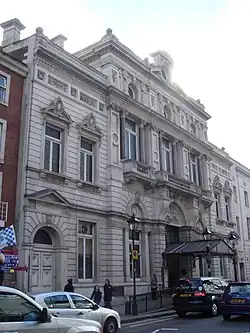 Fulham Town Hall (original Building and 1904-5 Extension) |
| Gatehouse at HM Prison Wormwood Scrubs | Hammersmith and Fulham | Gatehouse | 1885 | 6 March 2009 | TQ2220281165 51°30′58″N 0°14′25″W / 51.516199°N 0.240245°W |
1393182 | .JPG.webp) Gatehouse at HM Prison Wormwood Scrubs |
| Chapel at HM Prison Wormwood Scrubs | Hammersmith and Fulham | Chapel | 1894–1899 | 6 March 2009 | TQ2219581220 51°31′00″N 0°14′25″W / 51.516695°N 0.240327°W |
1393205 | .JPG.webp) Chapel at HM Prison Wormwood Scrubs |
| Greenside Primary School, Westville Road W12 | Hammersmith and Fulham | Elementary School | 1950 | 30 March 1993 | TQ2243979754 51°30′12″N 0°14′14″W / 51.503467°N 0.237321°W |
1253036 | 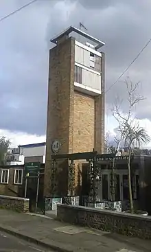 Greenside Primary School, Westville Road W12 |
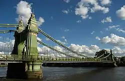
| Hammersmith Bridge | Hammersmith and Fulham | Suspension Bridge | 1884–1886 | 12 May 1970 | TQ2300578145 51°29′20″N 0°13′47″W / 51.488884°N 0.229731°W |
1079819 | |
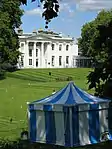
| Hurlingham House | Hammersmith and Fulham | House | 1760 | 7 May 1954 | TQ2505975670 51°27′58″N 0°12′04″W / 51.466191°N 0.201037°W |
1192658 | |
| Kelmscott House, 26 Upper Mall | Hammersmith and Fulham | House | c. 1785 | 17 June 1954 | TQ2260078325 51°29′26″N 0°14′08″W / 51.490589°N 0.235498°W |
1193040 |  Kelmscott House, 26 Upper Mall |
| Parish Church of All Saints, Putney Bridge Approach SW6 | Fulham, Hammersmith and Fulham | Parish Church | 14th century to early 15th century | 7 May 1954 | TQ2430375919 51°28′07″N 0°12′43″W / 51.468595°N 0.211828°W |
1286566 | 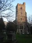 Parish Church of All Saints, Putney Bridge Approach SW6 |
| Royal Masonic Hospital, with Associated Boundary Walls, Gates, Railings and Planters, Ravenscourt Park W6 | Hammersmith and Fulham | Gate | 1933 | 10 October 1980 | TQ2217478945 51°29′47″N 0°14′29″W / 51.496254°N 0.241417°W |
1192740 |  Royal Masonic Hospital, with Associated Boundary Walls, Gates, Railings and Planters, Ravenscourt Park W6 |
| Sandford Manor House, Kings Road SW6 | Hammersmith and Fulham | Manor House | Later 17th century | 7 May 1954 | TQ2602177094 51°28′44″N 0°11′12″W / 51.478775°N 0.186689°W |
1286723 | 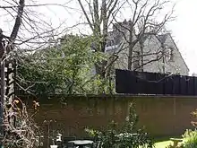 Sandford Manor House, Kings Road SW6 |
| Sir William Powell's Almshouses, Including Gate Piers, Railings and Gates to West, 1–12 Church Gate SW6 | Hammersmith and Fulham | Almshouse | 1869 | 12 May 1970 | TQ2431775994 51°28′09″N 0°12′42″W / 51.469266°N 0.2116°W |
1079809 | 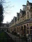 Sir William Powell's Almshouses, Including Gate Piers, Railings and Gates to West, 1–12 Church Gate SW6 |
| Sussex House including Boundary Wall to North | 12-14 Upper Mall, Hammersmith W6 | House | c. 1726 | 14 February 1985 | TQ2264478355 51°29′27″N 0°14′05″W / 51.490849°N 0.234855°W |
1079781 | 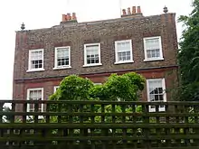 Sussex House including Boundary Wall to North |
| 22 and 22A, Avonmore Road W14 | Hammersmith and Fulham | Studio House | 1888-9 | 22 March 1983 | TQ2458678850 51°29′42″N 0°12′24″W / 51.494874°N 0.206723°W |
1079838 |  Upload Photo |
| 7 Hammersmith Terrace | Hammersmith and Fulham | Terraced House | c1760-70 | 17 June 1954 | TQ2212178230 51°29′23″N 0°14′33″W / 51.489839°N 0.242427°W |
1079821 | |
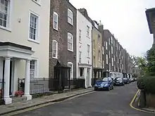
| 13 and 15, Upper Mall W6 | Hammersmith and Fulham | House | Early 18th century | 14 February 1985 | TQ2266278331 51°29′26″N 0°14′05″W / 51.49063°N 0.234604°W |
1079782 | 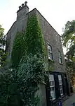 13 and 15, Upper Mall W6 |
| Campbell Family Mausoleum | St Mary's Catholic Cemetery, Harrow Road, Kensal Green | Mausoleum | 1904 | 14 February 1985 | TQ2260282661 51°31′46″N 0°14′02″W / 51.529557°N 0.23396345°W |
1079822 | Upload Photo |
Notes
- 1 2 The date given is the date used by Historic England as significant for the initial building or that of an important part in the structure's description.
- 1 2 Sometimes known as OSGB36, the grid reference is based on the British national grid reference system used by the Ordnance Survey.
- 1 2 The "List Entry Number" is a unique number assigned to each listed building and scheduled monument by Historic England.
External links
 Media related to Grade I listed buildings in the London Borough of Hammersmith and Fulham at Wikimedia Commons
- Media related to Grade II* listed buildings in the London Borough of Hammersmith and Fulham at Wikimedia Commons


This article is issued from Wikipedia. The text is licensed under Creative Commons - Attribution - Sharealike. Additional terms may apply for the media files.