There are over 20,000 Grade II* listed buildings in England. This page is a list of these buildings in the City of London.
Buildings
Churches
| Name | Location | Type | Completed [note 1] | Date designated | Grid ref.[note 2] Geo-coordinates |
Entry number [note 3] | Image |
|---|---|---|---|---|---|---|---|
| Church of St Bartholomew the Less, St Bartholomew's Hospital | City and County of the City of London | Church | Earlier | 4 January 1950 | TQ3188281600 51°31′05″N 0°06′02″W / 51.517933°N 0.100656°W |
1180946 | 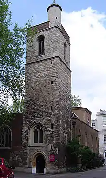 Church of St Bartholomew the Less, St Bartholomew's Hospital |
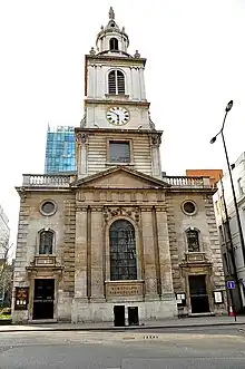
| Church of St Botolph | City and County of the City of London | Church | 1725-9 | 4 January 1950 | TQ3320681500 51°31′00″N 0°04′54″W / 51.516724°N 0.081623°W |
1064747 | |
| Tower of Former Church of St Albans | City and County of the City of London | Church | 1682-7 | 4 January 1950 | TQ3234081465 51°31′00″N 0°05′39″W / 51.516613°N 0.09411°W |
1079120 | 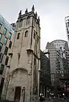 Tower of Former Church of St Albans |
Livery company halls
| Name | Location | Type | Completed [note 1] | Date designated | Grid ref.[note 2] Geo-coordinates |
Entry number [note 3] | Image |
|---|---|---|---|---|---|---|---|
| Armourers and Braziers Hall | City and County of the City of London | Livery Hall | 1840 | 4 January 1950 | TQ3266381538 51°31′02″N 0°05′22″W / 51.517194°N 0.08943°W |
1192163 | |
| Drapers' Hall | City and County of the City of London | Livery Hall | 19th century | 5 June 1972 | TQ3287981295 51°30′54″N 0°05′11″W / 51.514959°N 0.08641°W |
1358902 | |
| Dyers' Hall | City and County of the City of London | Livery Hall | Mid-late 19th century | 4 January 1950 | TQ3254880846 51°30′40″N 0°05′29″W / 51.511002°N 0.091346°W |
1359153 | |
| Fishmongers' Hall | City and County of the City of London | Livery Hall | 1831-4 | 5 June 1972 | TQ3280680671 51°30′34″N 0°05′16″W / 51.509369°N 0.087697°W |
1359203 | |
| Innholders Hall | City and County of the City of London | Livery Hall | 1670 | 4 January 1950 | TQ3252680830 51°30′39″N 0°05′30″W / 51.510863°N 0.091669°W |
1064708 |  Innholders Hall |
| Merchant Taylors' Hall | City and County of the City of London | Kitchen | Early 15th century | 5 June 1972 | TQ3297481188 51°30′50″N 0°05′06″W / 51.513975°N 0.085082°W |
1358898 | |
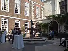
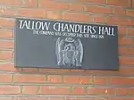
| Tallow Chandlers' Hall | City and County of the City of London | Courtyard | 1671-2 | 4 January 1950 | TQ3254580890 51°30′41″N 0°05′29″W / 51.511398°N 0.091373°W |
1064685 | |
| Watermen's Hall | City and County of the City of London | Livery Hall | 1778–80 | 4 January 1950 | TQ3306780691 51°30′34″N 0°05′02″W / 51.509487°N 0.08393°W |
1285652 |
Other
| Name | Location | Type | Completed [note 1] | Date designated | Grid ref.[note 2] Geo-coordinates |
Entry number [note 3] | Image |
|---|---|---|---|---|---|---|---|
| 2 Wardrobe Place | City and County of the City of London | House | c. 1680 | 5 June 1972 | TQ3187381039 51°30′46″N 0°06′04″W / 51.512894°N 0.100995°W |
1180808 | 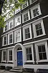 2 Wardrobe Place |
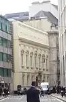
| Bishopsgate Institute and Library | City and County of the City of London | Institute | 1894 | 16 July 1964 | TQ3340681729 51°31′07″N 0°04′43″W / 51.518735°N 0.078656°W |
1191674 | 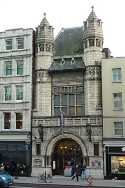 Bishopsgate Institute and Library |
| Bracken House | City and County of the City of London | Office | Mid-20th century | 13 August 1987 | TQ3220380992 51°30′45″N 0°05′47″W / 51.512395°N 0.09626°W |
1262582 | |
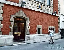
| Buttery at Inner Temple Hall | Inner Temple, City and County of the City of London | Buttery | 14th century | 4 January 1950 | TQ3122981010 51°30′46″N 0°06′37″W / 51.512783°N 0.110281°W |
1359174 | 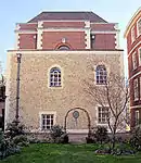 Buttery at Inner Temple Hall |
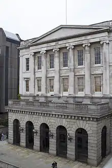
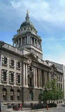
| Central Criminal Court | City and County of the City of London | Court House | 1900–07 | 28 February 1970 | TQ3180881329 51°30′56″N 0°06′07″W / 51.515515°N 0.101823°W |
1359218 | |
| Chapter House of St Paul's Cathedral | City and County of the City of London | Chapter House | 1712 | 4 January 1950 | TQ3200381200 51°30′52″N 0°05′57″W / 51.514311°N 0.099063°W |
1358896 | .jpg.webp) Chapter House of St Paul's Cathedral |
| City of London Club | City and County of the City of London | Clubhouse | 1833–1834 | 1 February 1974 | TQ3300081297 51°30′54″N 0°05′05″W / 51.514949°N 0.084667°W |
1064593 | |
| Crescent House Including Ground Floor Shops and Shakespeare Public House | Golden Lane Estate, City and County of the City of London | Flats | 1958–1962 | 4 December 1997 | TQ3210282099 51°31′21″N 0°05′50″W / 51.522366°N 0.0973°W |
1021941 |  Crescent House Including Ground Floor Shops and Shakespeare Public House |
| East Building of Central Market | City and County of the City of London | Meat Market | 1868 | 5 June 1972 | TQ3187881780 51°31′10″N 0°06′02″W / 51.519552°N 0.100646°W |
1285241 | 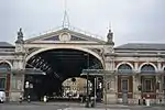 East Building of Central Market |
| Footings of Destroyed Cloister and Chapter House | City and County of the City of London | Chapter House | 14th century | 5 June 1972 | TQ3201681104 51°30′48″N 0°05′56″W / 51.513445°N 0.098912°W |
1358873 |  Footings of Destroyed Cloister and Chapter House |
| Former Glyn Mills Bank (1 Fleet Street) | City and County of the City of London | Bank (financial) | 1879 | 26 January 1970 | TQ3112281094 51°30′49″N 0°06′42″W / 51.513563°N 0.111791°W |
1064692 | 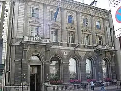 Former Glyn Mills Bank (1 Fleet Street) |
| Former Guildhall Library and Museum | City and County of the City of London | Warehouse | c. 1960 | 10 November 1977 | TQ3252981387 51°30′57″N 0°05′29″W / 51.515868°N 0.091417°W |
1064744 | 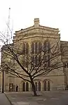 Former Guildhall Library and Museum |
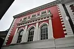
| Former Offices of the Bridewell Hospital | City and County of the City of London | Street Lamp | c. 1805 | 4 January 1950 | TQ3162881042 51°30′47″N 0°06′16″W / 51.512978°N 0.104523°W |
1359214 | .jpg.webp) Former Offices of the Bridewell Hospital |
| Former Port of London Authority Building | City and County of the City of London | Hotel | 1912–1922 | 3 March 1972 | TQ3345280797 51°30′37″N 0°04′42″W / 51.510349°N 0.078346°W |
1079138 | |
| Gatehouse to Church of St Bartholomew the Great | City and County of the City of London | Gatehouse | 13th century | 4 January 1950 | TQ3191281666 51°31′07″N 0°06′01″W / 51.51852°N 0.100199°W |
1358892 | 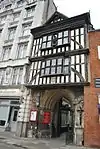 Gatehouse to Church of St Bartholomew the Great |
| Gateway with Adjoining Wall and Railing to Yard of Church of St Olave | City and County of the City of London | Gate | 1658 | 5 June 1972 | TQ3338380837 51°30′39″N 0°04′46″W / 51.510725°N 0.079325°W |
1064636 | 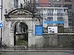 Gateway with Adjoining Wall and Railing to Yard of Church of St Olave |
| Hoare's Bank | City and County of the City of London | Courtyard | 1820–30 | 16 July 1954 | TQ3125881129 51°30′50″N 0°06′35″W / 51.513846°N 0.109819°W |
1192633 | 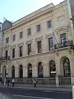 Hoare's Bank |
| Holland House, Bury Street | City and County of the City of London | Office | 1914 | 5 June 1972 | TQ3336081219 51°30′51″N 0°04′46″W / 51.514163°N 0.079511°W |
1064724 | .jpg.webp) Holland House, Bury Street |
| Hoop and Grapes Public House | Aldgate High Street | Public House | Late 17th century | 4 January 1950 | TQ3373081234 51°30′51″N 0°04′27″W / 51.51421°N 0.074177°W |
1064735 | .jpg.webp) Hoop and Grapes Public House |
| Inner Temple Gatehouse | City and County of the City of London | Shop | Modern | 4 January 1950 | TQ3118181113 51°30′49″N 0°06′39″W / 51.51372°N 0.110934°W |
1064693 | 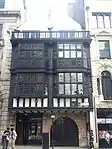 Inner Temple Gatehouse |
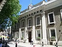
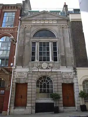
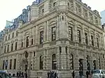
| Chartered Accountants' Hall, Institute of Chartered Accountants | City and County of the City of London | Professional Institute | 1889 | 4 January 1950 | TQ3275181447 51°30′59″N 0°05′18″W / 51.516355°N 0.088197°W |
1064586 |  Chartered Accountants' Hall, Institute of Chartered Accountants |
| King Edwards Buildings (post Office) | King Edward Street, EC2 | Post Office | 1907–11 | 6 August 1974 | TQ3200981425 51°30′59″N 0°05′56″W / 51.516331°N 0.098892°W |
1286242 | 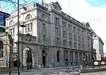 King Edwards Buildings (post Office) |
| King Edwards Buildings Post Office | 106–113 Newgate Street, EC2 | Post Office | 1907–11 | 6 August 1974 | TQ3189381388 51°30′58″N 0°06′02″W / 51.516026°N 0.100577°W |
1194097 | %252C_Newgate_Street%252C_London_01.jpg.webp) King Edwards Buildings Post Office |
| Leadenhall Market with Subsidiary Numbering | City and County of the City of London | Livestock Market | 1881 | 5 June 1972 | TQ3308681060 51°30′46″N 0°05′01″W / 51.512799°N 0.083518°W |
1286182 | 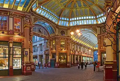 Leadenhall Market with Subsidiary Numbering |
| Lloyd's Register | City and County of the City of London | Commercial Office | 1900 | 5 June 1972 | TQ3341981029 51°30′45″N 0°04′43″W / 51.512442°N 0.078733°W |
1192466 | |
| London Stone with Stone Surround and Iron Grille Set into Base of Number 111 | City and County of the City of London | Grille | 19th century | 5 June 1972 | TQ3267580909 51°30′42″N 0°05′22″W / 51.511538°N 0.089494°W |
1286846 | 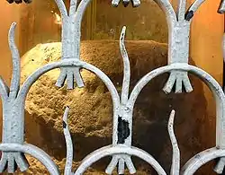 London Stone with Stone Surround and Iron Grille Set into Base of Number 111 |
| Lutyens House | City and County of the City of London | Underground Railway Station | 1924-7 | 4 January 1950 | TQ3279881667 51°31′06″N 0°05′15″W / 51.518321°N 0.087437°W |
1064691 |  Lutyens House |
| Mercer's School Hall and Buildings Adjoining Mercer's School Hall | City and County of the City of London | School Hall | Late 14th century | 4 January 1950 | TQ3124481527 51°31′03″N 0°06′36″W / 51.517426°N 0.109873°W |
1064743 | |
| National Westminster Bank Including Lothbury Gallery | City and County of the City of London | Art Gallery | 1988 | 10 November 1977 | TQ3277181283 51°30′54″N 0°05′17″W / 51.514877°N 0.08797°W |
1079136 | 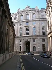 National Westminster Bank Including Lothbury Gallery |
| Number 10 and Attached Railings Number 25 and Attached Railings | City and County of the City of London | Fireproof Building | 1897–1902 | 27 April 1989 | TQ3115781506 51°31′02″N 0°06′40″W / 51.517257°N 0.111134°W |
1246854 | .jpg.webp) Number 10 and Attached Railings Number 25 and Attached Railings |
| 15 Took's Court | City of London, EC4 | Terraced House | c. 1720 | 24 October 1951 | TQ3116181451 51°31′00″N 0°06′40″W / 51.516762°N 0.111097°W |
1244733 | 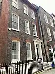 15 Took's Court |
| Number 19 and Cellar in Sub Basement | City and County of the City of London | Town House | Late 18th century | 19 May 1983 | TQ3270780944 51°30′43″N 0°05′20″W / 51.511845°N 0.08902°W |
1079099 | 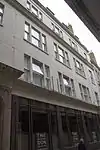 Number 19 and Cellar in Sub Basement |
| Pair of Gatepiers Attached to Number 1 | City and County of the City of London | Gate Pier | Late 17th century | 5 June 1972 | TQ3185581215 51°30′52″N 0°06′04″W / 51.51448°N 0.101189°W |
1064739 | 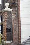 Pair of Gatepiers Attached to Number 1 |
| Partner's House, Whitbread's Brewery and Attached Railings | City and County of the City of London | House | Early 18th century | 29 December 1950 | TQ3247581946 51°31′15″N 0°05′31″W / 51.520904°N 0.091985°W |
1262268 | .jpg.webp) Partner's House, Whitbread's Brewery and Attached Railings |
| Port of London Authority Building (that Part Within London Borough of Tower Hamlets) | City and County of the City of London | Office | 1912 To 1922 | 3 March 1972 | TQ3347480778 51°30′37″N 0°04′41″W / 51.510173°N 0.078036°W |
1357519 | |
| Public Record Office | City and County of the City of London | Office | 1851–66 | 9 January 1970 | TQ3121381287 51°30′55″N 0°06′37″W / 51.515276°N 0.110409°W |
1359155 | |
| Rear Wing of Middle Temple Gatehouse | Middle Temple, City and County of the City of London | Inns of Court | Late 18th century | 5 June 1972 | TQ3113881095 51°30′49″N 0°06′42″W / 51.513568°N 0.11156°W |
1285975 | 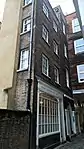 Rear Wing of Middle Temple Gatehouse |
| Screen Wall and Colonnade, St Bartholomew's Hospital | City and County of the City of London | Grille | 18th century | 5 June 1972 | TQ3187481615 51°31′05″N 0°06′03″W / 51.51807°N 0.100766°W |
1358893 | 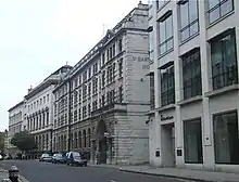 Screen Wall and Colonnade, St Bartholomew's Hospital |
| St Paul's Cathedral Choir School | City and County of the City of London | School | 2007 | 3 January 2007 | TQ3217881114 51°30′49″N 0°05′48″W / 51.513497°N 0.096575°W |
1391842 |  St Paul's Cathedral Choir School |
| The Aldgate School | City and County of the City of London | Statue | 1908 | 5 June 1972 | TQ3351381180 51°30′50″N 0°04′38″W / 51.513776°N 0.077323°W |
1285969 | |
| The Black Friar Public House | City and County of the City of London | Inn Sign | c. 1875 | 5 June 1972 | TQ3168480948 51°30′44″N 0°06′14″W / 51.51212°N 0.103751°W |
1285723 | .jpg.webp) The Black Friar Public House |
| The Daily Express Building | City and County of the City of London | Newspaper Office | 1932 | 15 March 1972 | TQ3154381201 51°30′52″N 0°06′20″W / 51.514427°N 0.105688°W |
1064659 | |
| Wood Street Police Station | City and County of the City of London | Apartment | 1963–1966 | 24 April 1998 | TQ3236381471 51°31′00″N 0°05′38″W / 51.516662°N 0.093776°W |
1323699 | 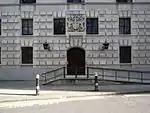 Wood Street Police Station |
| 1–3 Amen Court | City and County of the City of London | Row | Late 17th century | 4 January 1950 | TQ3184181222 51°30′52″N 0°06′05″W / 51.514546°N 0.101388°W |
1064737 | 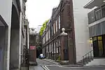 1–3 Amen Court |
| 41 & 42 Cloth Fair | City and County of the City of London | House | Early 17th century | 4 January 1950 | TQ3192081715 51°31′08″N 0°06′00″W / 51.518958°N 0.100066°W |
1064703 | 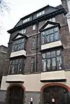 41 & 42 Cloth Fair |
| 3 Middle Temple Lane | Middle Temple, City and County of the City of London | Inns of Court | Late 17th century | 4 January 1950 | TQ3115181082 51°30′48″N 0°06′41″W / 51.513448°N 0.111378°W |
1064615 | 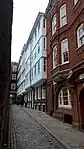 3 Middle Temple Lane |
| 42 Crutched Friars | City and County of the City of London | House | Early 18th century | 4 January 1950 | TQ3343080903 51°30′41″N 0°04′43″W / 51.511307°N 0.078623°W |
1064677 | 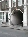 42 Crutched Friars |
| 15–22 Cornhill; 71–77 Lombard Street | City and County of the City of London | Bank | Altered 1949 | 10 November 1977 | TQ3280081095 51°30′47″N 0°05′15″W / 51.51318°N 0.087624°W |
1064709 | .jpg.webp) 15–22 Cornhill; 71–77 Lombard Street |
| The City and County of London Troops War Memorial | Cornhill | War Memorial | 1920 | 5 June 1972 | TQ3276781132 51°30′49″N 0°05′17″W / 51.513521°N 0.088085°W |
1064714 | .jpg.webp) The City and County of London Troops War Memorial |
| 20 St Swithen's Lane | City and County of the City of London | House | Pre 1767 | 5 June 1980 | TQ3271880940 51°30′43″N 0°05′20″W / 51.511807°N 0.088863°W |
1079092 | 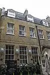 20 St Swithen's Lane |
| 27 & 28 Queen Street | City and County of the City of London | House | Mid 18th century | 4 January 1950 | TQ3242880951 51°30′43″N 0°05′35″W / 51.511974°N 0.093035°W |
1079139 | 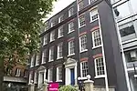 27 & 28 Queen Street |
| 8 Kings Bench Walk | Inner Temple, City and County of the City of London | Inns of Court | Early 18th century | 4 January 1950 | TQ3135280960 51°30′44″N 0°06′31″W / 51.512305°N 0.108528°W |
1193194 | 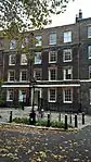 8 Kings Bench Walk |
| 7 Lothbury | City and County of the City of London | Commercial Office | 1866 | 16 July 1964 | TQ3273081275 51°30′53″N 0°05′19″W / 51.514814°N 0.088564°W |
1193583 | 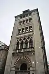 7 Lothbury |
| 4 Essex Court | Middle Temple, City and County of the City of London | Inns of Court | Early 18th century | 5 June 1972 | TQ3109581028 51°30′47″N 0°06′44″W / 51.512976°N 0.112205°W |
1193758 | 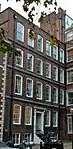 4 Essex Court |
| 3 North, Kings Bench Walk | Inner Temple, City and County of the City of London | House | Early 19th century | 4 January 1950 | TQ3133181053 51°30′47″N 0°06′32″W / 51.513146°N 0.108796°W |
1359176 | 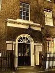 3 North, Kings Bench Walk |
| 1 & 2 Laurence Pountney Hill | City and County of the City of London | House | 1703 | 4 January 1950 | TQ3271280838 51°30′39″N 0°05′20″W / 51.510892°N 0.088988°W |
1359204 | 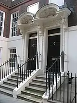 1 & 2 Laurence Pountney Hill |
| 33 & 35 Eastcheap | City and County of the City of London | Office | 1868 | 5 March 1971 | TQ3307480834 51°30′39″N 0°05′02″W / 51.510771°N 0.083776°W |
1359154 | 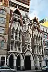 33 & 35 Eastcheap |
| 51–53 Threadneedle Street; 9 Old Broad Street | City and County of the City of London | Bank (financial) | 1922–36 | 8 January 1971 | TQ3294081234 51°30′52″N 0°05′08″W / 51.514397°N 0.085555°W |
1358901 |  51–53 Threadneedle Street; 9 Old Broad Street |
| 12 Tokenhouse Yard | City and County of the City of London | Bank (financial) | Dated 1872 | 10 November 1977 | TQ3275581358 51°30′56″N 0°05′17″W / 51.515554°N 0.088173°W |
1358903 |  12 Tokenhouse Yard |
| 46 Aldgate High Street | City and County of the City of London | House | Late 17th century | 4 January 1950 | TQ3373581237 51°30′51″N 0°04′27″W / 51.514236°N 0.074104°W |
1359144 | 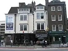 46 Aldgate High Street |
| 22A College Hill | City and County of the City of London | House | c. 1680 | 4 January 1950 | TQ3251180885 51°30′41″N 0°05′31″W / 51.511361°N 0.091865°W |
1359164 | _College_Hill_EC4_(1).jpg.webp) 22A College Hill |
| 13 & 15 Moorgate | City and County of the City of London | Commercial Office | 1890–1893 | 5 June 1972 | TQ3265281347 51°30′56″N 0°05′23″W / 51.51548°N 0.08966°W |
1359212 |  13 & 15 Moorgate |
| 60 & 61 Mark Lane | City and County of the City of London | Office | 1864 | 5 June 1972 | TQ3333180840 51°30′39″N 0°04′48″W / 51.510764°N 0.080072°W |
1359196 |  60 & 61 Mark Lane |
| 22 College Hill | City and County of the City of London | Gate | c. 1680 | 4 January 1950 | TQ3249480902 51°30′41″N 0°05′32″W / 51.511518°N 0.092103°W |
1064707 | 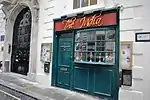 22 College Hill |
| 2 Middle Temple Lane | Middle Temple, City and County of the City of London | Inns of Court | Late 17th century | 4 January 1950 | TQ3114581097 51°30′49″N 0°06′41″W / 51.513585°N 0.111459°W |
1285986 | 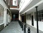 2 Middle Temple Lane |
| 337 & 338 High Holborn | City and County of the City of London | House | c. 1586 | 14 May 1974 | TQ3114181588 51°31′05″N 0°06′41″W / 51.517998°N 0.111334°W |
1246102 | 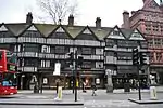 337 & 338 High Holborn |
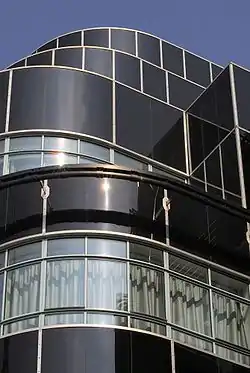
| No 1 Poultry | 1 Poultry, London, EC2R 8EJ | Office and retail building | 1998 | 28 November 2016 | TQ3256981105 51°30′48″N 0°05′27″W / 51.513325°N 0.090946693°W |
1428881 | |
| St Michael Cornhill War Memorial | St Michael's Alley, Cornhill, City of London, EC3V 3ND | War memorial | 1920 | 1 December 2016 | TQ3293681110 51°30′48″N 0°05′08″W / 51.513283°N 0.085659159°W |
1439646 | |
| National Submarine War Memorial | Victoria Embankment, City of London, EC4Y 0HJ | War memorial | 1922 | 5 June 1972 | TQ3118380797 51°30′39″N 0°06′40″W / 51.510880°N 0.11102304°W |
1079109 | |
| Royal Fusiliers War Memorial | High Holborn, Holborn, London, EC1N 2LL | War memorial | 1922 | 5 June 1972 | TQ3117581601 51°31′05″N 0°06′39″W / 51.518107°N 0.11083934°W |
1064638 |
.jpg.webp)

.jpg.webp)

.jpg.webp)
.jpg.webp)
See also
Notes
- 1 2 3 The date given is the date used by Historic England as significant for the initial building or that of an important part in the structure's description.
- 1 2 3 Sometimes known as OSGB36, the grid reference is based on the British national grid reference system used by the Ordnance Survey.
- 1 2 3 The "List Entry Number" is a unique number assigned to each listed building and scheduled monument by Historic England.
External links
 Media related to Grade II* listed buildings in the City of London at Wikimedia Commons
| Wards |  | |
|---|---|---|
| Enclaves | ||
| Localities | ||
| Attractions |
| |
| Notable structures | ||
| Civil parishes | ||
| Bridges | ||
| Rail and tube stations | ||
| Topics | ||
| ||
This article is issued from Wikipedia. The text is licensed under Creative Commons - Attribution - Sharealike. Additional terms may apply for the media files.