There are over 20,000 Grade II* listed buildings in England. This page is a list of these buildings in the district of Telford and Wrekin in Shropshire.
Telford and Wrekin
| Name | Location | Type | Completed [note 1] | Date designated | Grid ref.[note 2] Geo-coordinates |
Entry number [note 3] | Image |
|---|---|---|---|---|---|---|---|
| Church of St Michael and All Angels | Chetwynd, Telford and Wrekin | Church | 1865-1867 | 18 June 1959 | SJ7356221310 52°47′19″N 2°23′36″W / 52.788708°N 2.393467°W |
1054109 | 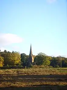 Church of St Michael and All Angels |
| Church of St. Luke | Sambrook, Chetwynd, Telford and Wrekin | Church | 1856 | 8 April 1983 | SJ7145924494 52°49′02″N 2°25′30″W / 52.817222°N 2.424928°W |
1205992 | 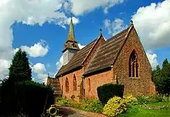 Church of St. Luke |
| Manor Farmhouse | Sambrook, Chetwynd, Telford and Wrekin | Farmhouse | Early 18th century | 8 April 1983 | SJ7141524748 52°49′10″N 2°25′32″W / 52.819503°N 2.425604°W |
1206032 |  Upload Photo |
| Parish Church (chapel) | Woodcote, Chetwynd Aston and Woodcote, Telford and Wrekin | Chapel | Late 12th century | 18 June 1959 | SJ7676215415 52°44′09″N 2°20′44″W / 52.735864°N 2.345598°W |
1292305 | Upload Photo |
| Church Aston Manor | Church Aston, Telford and Wrekin | House | Earlier Core | 4 January 1954 | SJ7423417676 52°45′22″N 2°23′00″W / 52.756074°N 2.383215°W |
1367402 | Upload Photo |
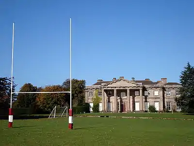
| Longford Hall | Longford, Church Aston, Telford and Wrekin | Country House | 1794-1797 | 18 June 1959 | SJ7286218251 52°45′40″N 2°24′13″W / 52.761175°N 2.403592°W |
1208541 | |
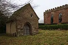
| Talbot Chapel | Longford, Church Aston, Telford and Wrekin | Church | 13th century | 18 June 1959 | SJ7259718452 52°45′47″N 2°24′27″W / 52.762969°N 2.407535°W |
1037009 | |
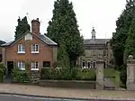
| Provosts House | Edgmond, Telford and Wrekin | House | Early 14th century | 18 June 1959 | SJ7196919212 52°46′11″N 2°25′01″W / 52.769768°N 2.416907°W |
1367393 | Upload Photo |
| Arcade to South East of Ercall Hall | High Ercall, Ercall Magna, Telford and Wrekin | Arcade | c. 1608 | 18 June 1959 | SJ5941417377 52°45′09″N 2°36′10″W / 52.752473°N 2.602756°W |
1038605 | 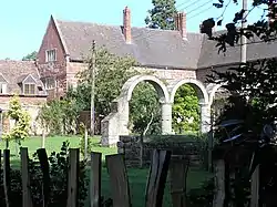 Arcade to South East of Ercall Hall |
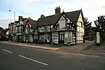
| Ercall Hall | High Erscall, Ercall Magna, Telford and Wrekin | House | 1608 | 4 January 1952 | SJ5941417420 52°45′10″N 2°36′10″W / 52.75286°N 2.602761°W |
1187259 | |
| Church of St. Catherine | Eyton upon the Weald Moors, Telford and Wrekin | Church | 1743 | 18 June 1959 | SJ6509714835 52°43′48″N 2°31′06″W / 52.730021°N 2.51829°W |
1038622 | 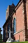 Church of St. Catherine |
| Church of St Leonard | Malinslee, Great Dawley, Telford and Wrekin | Church | 1805 | 26 March 1968 | SJ6890108117 52°40′12″N 2°27′41″W / 52.669863°N 2.461324°W |
1367391 | 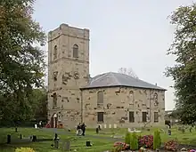 Church of St Leonard |
| Stables at Apley Castle | Apley, Hadley & Leegomery, Telford and Wrekin | Manor House | Early to Mid 14th century | 8 April 1983 | SJ6548913178 52°42′55″N 2°30′44″W / 52.715151°N 2.512311°W |
1201614 |  Stables at Apley Castle |
| Church of St Chad | Kynnersley, Telford and Wrekin | Church | Medieval | 18 June 1959 | SJ6727216703 52°44′49″N 2°29′11″W / 52.746949°N 2.48627°W |
1374541 | 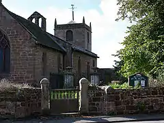 Church of St Chad |
| Church of St Lawrence | Little Wenlock, Telford and Wrekin | Church | Medieval | 8 April 1983 | SJ6470406839 52°39′29″N 2°31′24″W / 52.658117°N 2.523249°W |
1208381 | 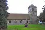 Church of St Lawrence |
| Church of St Michael | Madeley, Telford and Wrekin | Church | 1796 | 8 April 1983 | SJ6962504091 52°38′01″N 2°27′01″W / 52.633713°N 2.450246°W |
1293011 | _-_geograph.org.uk_-_1503876.jpg.webp) Church of St Michael |
| Former Water Mill South of Madeley Court | Madeley, Telford and Wrekin | Watermill | 17th century | 8 April 1983 | SJ6955305066 52°38′33″N 2°27′05″W / 52.642474°N 2.4514°W |
1033281 | Upload Photo |
| Garden Walls North West and West of Madeley Court | Madeley, Telford and Wrekin | Walls | Late 17th century | 8 April 1983 | SJ6946305174 52°38′36″N 2°27′10″W / 52.643439°N 2.45274°W |
1033280 | Upload Photo |
| Gatepiers West of the Old Vicarage | Madeley, Telford and Wrekin | Gate | Modern | 8 April 1983 | SJ6963104144 52°38′03″N 2°27′01″W / 52.63419°N 2.450162°W |
1208716 | Upload Photo |
| Madeley Court | Madeley, Telford and Wrekin | House | 16th century | 8 April 1983 | SJ6954905153 52°38′36″N 2°27′05″W / 52.643256°N 2.451467°W |
1352026 | |
| Sundial immediately West of Madeley Court | Madeley, Telford and Wrekin | Sundial | 17th century | 8 April 1983 | SJ6949805151 52°38′36″N 2°27′08″W / 52.643235°N 2.452221°W |
1352027 | Upload Photo |
| The Old Hall | Madeley, Telford and Wrekin | Apartment | c. 1980 | 8 April 1983 | SJ6945104238 52°38′06″N 2°27′10″W / 52.635025°N 2.452831°W |
1208643 | Upload Photo |
| The Old Vicarage | Madeley, Telford and Wrekin | House | c. 1700 | 8 April 1983 | SJ6964804138 52°38′03″N 2°27′00″W / 52.634137°N 2.449911°W |
1352023 | Upload Photo |
| Central Block, Adams' Grammar School | Newport, Telford and Wrekin | Grammar School | 1656 | 28 April 1952 | SJ7433719146 52°46′09″N 2°22′54″W / 52.769293°N 2.381805°W |
1054359 | |
| Chetwynd House | Newport, Telford and Wrekin | House | Mid 18th century | 28 April 1952 | SJ7429019458 52°46′20″N 2°22′57″W / 52.772095°N 2.382526°W |
1054385 | Upload Photo |
| Church of St Nicholas of Myra | Newport, Telford and Wrekin | Parish Church | 14th century | 28 April 1952 | SJ7450519186 52°46′11″N 2°22′46″W / 52.769661°N 2.379318°W |
1178337 | 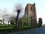 Church of St Nicholas of Myra |
| Old Guildhall | Newport, Telford and Wrekin | House | c. 1400 | 28 April 1952 | SJ7460518892 52°46′01″N 2°22′40″W / 52.767022°N 2.377813°W |
1177807 | |
| Hoo Hall | Horton, Preston upon the Weald Moors, Telford and Wrekin | House | 19th century | 18 June 1959 | SJ6847514812 52°43′48″N 2°28′06″W / 52.730022°N 2.468268°W |
1025044 | Upload Photo |
| Longdon Hall | Longdon-on-Tern, Rodington, Telford and Wrekin | House | Late 16th century | 18 June 1959 | SJ6226115392 52°44′05″N 2°33′37″W / 52.734837°N 2.560348°W |
1037002 | Upload Photo |
| Walcot Bridge | Walcot, Rodington, Telford and Wrekin | Road Bridge | 1782 | 8 April 1983 | SJ5931312395 52°42′28″N 2°36′13″W / 52.707682°N 2.603633°W |
1033347 | 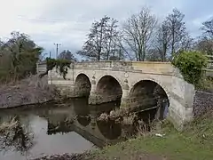 Walcot Bridge |
| Church of Holy Trinity | Coalbrookdale, The Gorge, Telford and Wrekin | Church | 1850-1854 | 8 April 1983 | SJ6705304465 52°38′13″N 2°29′18″W / 52.636925°N 2.488285°W |
1280353 | |
| Coalbrookdale Institute (premises of YHA) | Coalbrookdale, The Gorge, Telford and Wrekin | Institute | c. 1859 | 26 March 1968 | SJ6703404310 52°38′08″N 2°29′19″W / 52.63553°N 2.48855°W |
1054148 | .jpg.webp) Coalbrookdale Institute (premises of YHA) |
| Former Coalport Chinaworks | Coalport, The Gorge, Telford and Wrekin | Brick Kiln | 1792 | 26 March 1968 | SJ6955502436 52°37′08″N 2°27′04″W / 52.618832°N 2.451127°W |
1206637 | 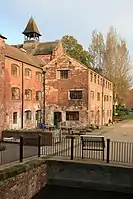 Former Coalport Chinaworks |
| Rose Cottage | Coalbrookdale, The Gorge, Telford and Wrekin | Timber Framed House | 1642 | 8 April 1983 | SJ6684604068 52°38′00″N 2°29′29″W / 52.633343°N 2.491304°W |
1367408 | 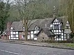 Rose Cottage |
| Severn Wharf Building (premises of Ironbridge Gorge Museum Trust) | Ironbridge, The Gorge, Telford and Wrekin | Warehouse | Mid to Late 19th century | 26 March 1968 | SJ6678203638 52°37′46″N 2°29′32″W / 52.629474°N 2.492206°W |
1293325 |  Severn Wharf Building (premises of Ironbridge Gorge Museum Trust) |
| Snapper Furnace | Coalbrookdale, The Gorge, Telford and Wrekin | Blast Furnace | 1792 | 8 April 1983 | SJ6679404883 52°38′26″N 2°29′32″W / 52.640666°N 2.492154°W |
1280325 | 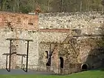 Snapper Furnace |
| The Bedlam Furnace | Ironbridge, The Gorge, Telford and Wrekin | Blast Furnace | Early 18th century | 26 March 1968 | SJ6782003358 52°37′37″N 2°28′37″W / 52.627019°N 2.476843°W |
1207904 | 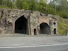 The Bedlam Furnace |
| The Grange (The Grove) | Coalbrookdale, The Gorge, Telford and Wrekin | House | Early/Mid 18th century | 8 April 1983 | SJ6666604961 52°38′29″N 2°29′39″W / 52.64136°N 2.494054°W |
1206355 | 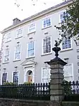 The Grange (The Grove) |
| The Market Buildings | Ironbridge, The Gorge, Telford and Wrekin | Market Hall | Early 19th century | 8 April 1983 | SJ6729503468 52°37′41″N 2°29′05″W / 52.627977°N 2.48461°W |
1279601 | 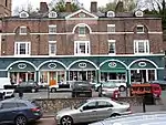 The Market Buildings |
| The Tontine Hotel | Ironbridge, The Gorge, Telford and Wrekin | Hotel | c. 1800 | 8 April 1983 | SJ6724603471 52°37′41″N 2°29′07″W / 52.628001°N 2.485334°W |
1207874 | 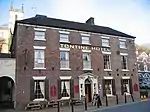 The Tontine Hotel |
| The Valley Hotel | Coalbrookdale, The Gorge, Telford and Wrekin | House | 18th century | 9 August 1974 | SJ6644403790 52°37′51″N 2°29′50″W / 52.630819°N 2.497215°W |
1054130 | 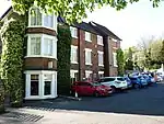 The Valley Hotel |
| Warehouse with Clock Tower | Coalbrookdale, The Gorge, Telford and Wrekin | Iron Works | c. 1792 | 8 April 1983 | SJ6673804720 52°38′21″N 2°29′35″W / 52.639198°N 2.492965°W |
1206215 | 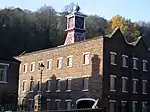 Warehouse with Clock Tower |
| Cherrington Manor House | Tibberton and Cherrington, Telford and Wrekin | House | 19th century | 8 April 1983 | SJ6660220162 52°46′41″N 2°29′48″W / 52.778001°N 2.496549°W |
1205917 | 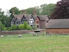 Cherrington Manor House |
| Church of St. John the Baptist | Great Bolas, Waters Upton, Telford and Wrekin | Church | Medieval | 18 June 1959 | SJ6473521353 52°47′19″N 2°31′28″W / 52.788588°N 2.524354°W |
1367430 | 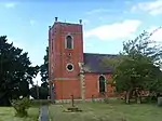 Church of St. John the Baptist |
| The Hall | Waters Upton, Telford and Wrekin | House | Early 18th century | 18 June 1959 | SJ6338219519 52°46′19″N 2°32′39″W / 52.772012°N 2.54421°W |
1352005 | .jpg.webp) The Hall |
| Arleston Manor House | Arleston, Wellington, Telford and Wrekin | Hunting Lodge | 17th century | 18 June 1959 | SJ6657810376 52°41′24″N 2°29′45″W / 52.690031°N 2.495905°W |
1351989 | Upload Photo |
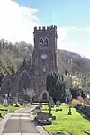
| Church of All Saints | Wellington, Telford and Wrekin | Church | 1790 | 8 April 1983 | SJ6511111719 52°42′07″N 2°31′04″W / 52.702011°N 2.517751°W |
1033317 | 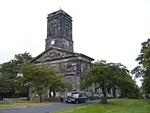 Church of All Saints |
| Cluddley Farmhouse | Cluddley, Wrockwardine, Telford and Wrekin | Farmhouse | 18th century | 8 April 1983 | SJ6318710261 52°41′20″N 2°32′46″W / 52.688777°N 2.546059°W |
1217801 | Upload Photo |
| Gazebo East of Orleton Hall | Watling Street, Wrockwardine, Telford and Wrekin | Gazebo | 18th century | 18 June 1959 | SJ6361211286 52°41′53″N 2°32′24″W / 52.69802°N 2.539885°W |
1033349 | .jpg.webp) Gazebo East of Orleton Hall |
| Orleton Hall | Watling Street, Wrockwardine, Telford and Wrekin | House | Pre 18th century | 18 June 1959 | SJ6345611283 52°41′53″N 2°32′32″W / 52.697982°N 2.542193°W |
1033348 | Upload Photo |
| Wrockwardine Hall | Wrockwardine, Wrockwardine, Telford and Wrekin | House | 1628 | 8 April 1983 | SJ6248112111 52°42′19″N 2°33′24″W / 52.705358°N 2.556715°W |
1218001 | Upload Photo |
.jpg.webp)
Notes
- ↑ The date given is the date used by Historic England as significant for the initial building or that of an important part in the structure's description.
- ↑ Sometimes known as OSGB36, the grid reference is based on the British national grid reference system used by the Ordnance Survey.
- ↑ The "List Entry Number" is a unique number assigned to each listed building and scheduled monument by Historic England.
External links
This article is issued from Wikipedia. The text is licensed under Creative Commons - Attribution - Sharealike. Additional terms may apply for the media files.