There are over 20,000 Grade II* listed buildings in England. This page is a list of these buildings in the district of Stroud in Gloucestershire.
Stroud
| Name | Location | Type | Completed [note 1] | Date designated | Grid ref.[note 2] Geo-coordinates |
Entry number [note 3] | Image |
|---|---|---|---|---|---|---|---|
| Stanton Monument, about 4m North-west of West Door in Churchyard of Church of St Kenelm | Alderley, Stroud | Chest Tomb | Late 16th century | 9 September 1985 | ST7683590806 51°36′56″N 2°20′09″W / 51.615599°N 2.335962°W |
1090614 |  Upload Photo |
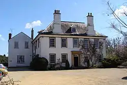
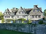
| The Grange | Alderley, Stroud | Country house | 1608 | 17 September 1952 | ST7687390985 51°37′02″N 2°20′08″W / 51.61721°N 2.335425°W |
1090620 | Upload Photo |
| The Mount House, with Railings Gates and Gate Piers on North Side | Alderley, Stroud | Detached House | Late 17th century | 17 September 1952 | ST7692390772 51°36′55″N 2°20′05″W / 51.615297°N 2.334689°W |
1090653 |  The Mount House, with Railings Gates and Gate Piers on North Side |
| Wick Court, with Railings and Wall to North | Arlingham, Stroud | House | 19th century | 10 January 1955 | SO7357610474 51°47′32″N 2°23′04″W / 51.792289°N 2.384527°W |
1090581 | .jpg.webp) Wick Court, with Railings and Wall to North |
| Jenner Hut, in Garden of the Chantry | Berkeley, Stroud | Summerhouse | Late 18th century | 21 October 1952 | ST6849399093 51°41′23″N 2°27′26″W / 51.6897°N 2.45719°W |
1090633 | 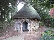 Jenner Hut, in Garden of the Chantry |
| The Chantry | Berkeley, Stroud | Detached House | Early 18th century | 21 October 1952 | ST6847799154 51°41′25″N 2°27′27″W / 51.690248°N 2.457427°W |
1304580 | |
| Barn adjoining and to North West of Ferris Court Farmhouse | Bisley-with-Lypiatt, Stroud | Clothing Workshop | c. 1700 | 28 June 1960 | SO8853804940 51°44′35″N 2°10′03″W / 51.743042°N 2.167409°W |
1340338 | Upload Photo |
| Chapel adjoining and to North West of the Mansion | Lypiatt Park, Bisley-with-Lypiatt, Stroud | Chapel | Late 14th century | 28 June 1960 | SO8857805880 51°45′05″N 2°10′01″W / 51.751495°N 2.166861°W |
1340354 | Upload Photo |
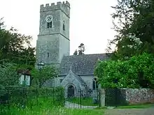
| Church of All Saints | Bisley, Bisley-with-Lypiatt, Stroud | Parish Church | 13th century and 14th century | 28 June 1960 | SO9036705932 51°45′07″N 2°08′27″W / 51.751996°N 2.140947°W |
1340362 | 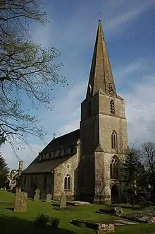 Church of All Saints |
| Cockpit with Dovecote approx. 40m South West of Jayne's Court | Bisley, Bisley-with-Lypiatt, Stroud | Dovecote | Early 19th century | 28 June 1960 | SO9026805846 51°45′04″N 2°08′33″W / 51.751221°N 2.142378°W |
1340357 | Upload Photo |
| Jayne's Court | Bisley, Bisley-with-Lypiatt, Stroud | House | c. 1715 | 28 June 1960 | SO9030505871 51°45′05″N 2°08′31″W / 51.751447°N 2.141843°W |
1091317 | Upload Photo |
| Lock Up with Forecourt Wall | Bisley, Bisley-with-Lypiatt, Stroud | Gaol | C20 | 28 June 1960 | SO9035406054 51°45′11″N 2°08′28″W / 51.753093°N 2.141138°W |
1340366 | 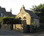 Lock Up with Forecourt Wall |
| Middle Lypiatt Farmhouse | Middle Lypiatt, Bisley-with-Lypiatt, Stroud | Farmhouse | Mid-late 16th century | 28 June 1960 | SO8772404684 51°44′27″N 2°10′45″W / 51.740723°N 2.179189°W |
1091275 | Upload Photo |
| Overcourt | Bisley, Bisley-with-Lypiatt, Stroud | Cruck House | 14th century | 28 June 1960 | SO9029705936 51°45′07″N 2°08′31″W / 51.752031°N 2.141961°W |
1303296 | Upload Photo |
| Poor Souls' Light in the Churchyard approx. 12m South West of Church of All Saints | Bisley, Bisley-with-Lypiatt, Stroud | Poor Souls Light | Late 13th century | 28 June 1960 | SO9034705918 51°45′07″N 2°08′28″W / 51.75187°N 2.141236°W |
1091286 | Upload Photo |
| Rectory Farmhouse and Rectory Cottage | Bisley, Bisley-with-Lypiatt, Stroud | Farmhouse | Late 17th century | 28 June 1960 | SO9047305846 51°45′04″N 2°08′22″W / 51.751225°N 2.139409°W |
1091270 | Upload Photo |
| Soloman's Court with Barn and Shelter Shed | Bournes Green, Bisley-with-Lypiatt, Stroud | House | Early 17th century | 28 June 1960 | SO9079703750 51°43′57″N 2°08′05″W / 51.732385°N 2.134659°W |
1155213 | Upload Photo |
| Sydenhams | Sydenhams, Bisley-with-Lypiatt, Stroud | Farmhouse | Early 17th century | 28 June 1960 | SO8973607819 51°46′08″N 2°09′01″W / 51.768951°N 2.150144°W |
1155892 | Upload Photo |
| The Bear Inn | Bisley, Bisley-with-Lypiatt, Stroud | Assembly Rooms | Early 17th century | 28 June 1960 | SO9031506054 51°45′11″N 2°08′30″W / 51.753092°N 2.141703°W |
1091261 | 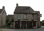 The Bear Inn |
| The Mansion | Bisley, Bisley-with-Lypiatt, Stroud | Detached house | Part 17th century | 28 June 1960 | SO9027805602 51°44′57″N 2°08′32″W / 51.749028°N 2.142227°W |
1155471 | Upload Photo |
| Througham Court | Througham, Bisley-with-Lypiatt, Stroud | Detached house | Early 17th century | 28 June 1960 | SO9207807915 51°46′11″N 2°06′58″W / 51.769853°N 2.116207°W |
1091244 | 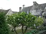 Througham Court |
| Througham Slad Farmhouse including 2 walled Courtyards with Gate Pier | Bisley-with-Lypiatt, Stroud | Farmhouse | Mid-late 16th century | 28 June 1960 | SO9224806559 51°45′28″N 2°06′49″W / 51.757663°N 2.113712°W |
1340339 |  Througham Slad Farmhouse including 2 walled Courtyards with Gate Pier |
| Waterlane House | Waterlane, Bisley-with-Lypiatt, Stroud | Detached House | 17th century | 1 November 1973 | SO9231704938 51°44′35″N 2°06′46″W / 51.74309°N 2.112676°W |
1091247 | Upload Photo |
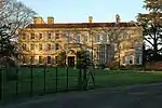
| Brookthorpe Court | Brookthorpe, Brookthorpe-with-Whaddon, Stroud | Country house | Late 16th century | 10 January 1955 | SO8352512291 51°48′32″N 2°14′25″W / 51.809009°N 2.240364°W |
1304418 | Upload Photo |
| Church of St Margaret | Whaddon, Brookthorpe-with-Whaddon, Stroud | Parish Church | 13th century | 10 January 1955 | SO8332613677 51°49′17″N 2°14′36″W / 51.821464°N 2.243318°W |
1340595 | |
| Church of St Swithun | Brookthorpe, Brookthorpe-with-Whaddon, Stroud | Parish Church | 13th century | 10 January 1955 | SO8350612266 51°48′32″N 2°14′26″W / 51.808784°N 2.240639°W |
1340597 | |
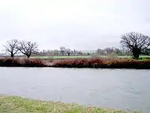
| Ebley Mill | Cainscross, Stroud | Boiler House | 1862 | 14 August 1967 | SO8293104613 51°44′24″N 2°14′55″W / 51.739958°N 2.2486°W |
1223361 |  Ebley Mill |
| Group of 12 Phillimore Memorials South East of South Porch of Parish Church of St George | Cam, Stroud | Altar Tomb | 18th century | 26 April 1984 | ST7573999324 51°41′32″N 2°21′09″W / 51.692139°N 2.352385°W |
1340963 | Upload Photo |
| Group of 7 Memorials, including Trotman and Turner, located 3m North of North Wall of North Aisle of Parish Church | Cam, Stroud | Chest Tomb | Early 17th century | 26 April 1984 | ST7572999354 51°41′33″N 2°21′09″W / 51.692408°N 2.352532°W |
1306101 | Upload Photo |
| Quarry Farmhouse | The Quarry, Cam, Stroud | Farmhouse | 17th century | 23 June 1983 | ST7382499480 51°41′36″N 2°22′48″W / 51.693455°N 2.380101°W |
1340555 | Upload Photo |
| Steps House | Lower Cam, Cam, Stroud | House | Late C16-early 17th century | 23 June 1983 | SO7466900645 51°42′14″N 2°22′05″W / 51.703968°N 2.367961°W |
1170505 | 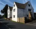 Steps House |
| Upper Knapp Farmhouse | Lower Cam, Cam, Stroud | Farmhouse | 16th century | 23 June 1983 | SO7458600403 51°42′06″N 2°22′09″W / 51.701789°N 2.369144°W |
1090913 | Upload Photo |
| Chalford Place | Chalford, Stroud | Detached House | Mid-16th century | 28 June 1960 | SO8918602473 51°43′15″N 2°09′29″W / 51.720874°N 2.157946°W |
1171410 | Upload Photo |
| Church of St John the Baptist | France Lynch, Chalford, Stroud | Anglican Church | 1855-7 | 24 March 1988 | SO9014103114 51°43′36″N 2°08′39″W / 51.726655°N 2.14414°W |
1305658 | _St_John_the_Baptist's_Church_-_geograph.org.uk_-_68222.jpg.webp) Church of St John the Baptist |
| The Leigh | Far Green, Coaley, Stroud | Farmhouse | 17th century | 26 April 1984 | SO7823000632 51°42′14″N 2°18′59″W / 51.704001°N 2.31643°W |
1090924 | Upload Photo |
| Church of St James | Cranham, Stroud | Parish Church | 12th century | 28 June 1960 | SO8910812410 51°48′37″N 2°09′34″W / 51.810217°N 2.15939°W |
1156148 | 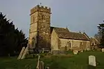 Church of St James |
| Kingshill House | Dursley, Stroud | Country house | 1705 | 23 June 1952 | ST7526899034 51°41′22″N 2°21′33″W / 51.68951°N 2.359178°W |
1219989 | Upload Photo |
| Raglan House | Dursley, Stroud | Row House | early-mid 18th century | 23 June 1952 | ST7580698219 51°40′56″N 2°21′05″W / 51.682206°N 2.351339°W |
1290869 | 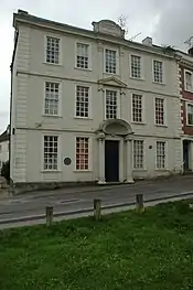 Raglan House |
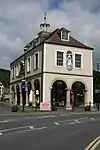
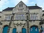
| Town Hall | Dursley, Stroud | Town Hall | 1738 | 23 June 1952 | ST7561998124 51°40′53″N 2°21′15″W / 51.681344°N 2.354037°W |
1220689 | |
| Alkerton Farmhouse | Eastington, Stroud | Farmhouse | C20 | 9 December 1986 | SO7751205172 51°44′41″N 2°19′38″W / 51.744792°N 2.327115°W |
1152797 | Upload Photo |
| Church of St Michael and Angels | Churchend, Eastington, Stroud | Anglican Church | 14th century | 10 January 1955 | SO7827105767 51°45′01″N 2°18′58″W / 51.750172°N 2.316159°W |
1152811 | 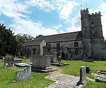 Church of St Michael and Angels |
| Nastend House | Nastend, Eastington, Stroud | House | Late 16th century | 9 December 1986 | SO7903406189 51°45′14″N 2°18′18″W / 51.753995°N 2.305132°W |
1090556 | Upload Photo |
| Elmore Court | Elmore Village, Elmore, Stroud | Country house | 1564-1588 | 10 January 1955 | SO7828515333 51°50′10″N 2°19′00″W / 51.836179°N 2.316558°W |
1090810 | |
| Gateway to South of Elmore Court | Elmore Village, Elmore, Stroud | Gate | Early 18th century | 10 January 1955 | SO7828715192 51°50′06″N 2°18′59″W / 51.834911°N 2.316521°W |
1340625 | 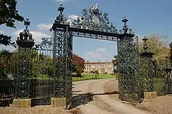 Gateway to South of Elmore Court |
| Monument to Arthur Knowles in the Churchyard approx. 9m South of South Porch to Church of St John | Elmore, Stroud | Chest Tomb | 1707 | 30 September 1985 | SO7672014898 51°49′56″N 2°20′21″W / 51.832205°N 2.339242°W |
1153809 | Upload Photo |
| Barn at Tanhouse Farm, about 60m North East of Church End House | Church End, Frampton on Severn, Stroud | Cruck House | 1688 | 9 December 1986 | SO7447106876 51°45′36″N 2°22′17″W / 51.759981°N 2.371285°W |
1090531 | 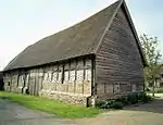 Barn at Tanhouse Farm, about 60m North East of Church End House |
| Church of St Mary the Virgin | Church End, Frampton on Severn, Stroud | Anglican Church | 14th century | 10 January 1955 | SO7434806940 51°45′38″N 2°22′23″W / 51.760551°N 2.373072°W |
1153176 | 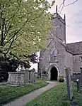 Church of St Mary the Virgin |
| Gatepiers and Gates to Frampton Court | Frampton on Severn, Stroud | Gate | Mid-18th century | 10 January 1955 | SO7536707920 51°46′10″N 2°21′30″W / 51.769408°N 2.358378°W |
1090541 | Upload Photo |
| Church of St James | Saul, Fretherne with Saul, Stroud | Anglican Church | 1140 | 10 January 1955 | SO7491109320 51°46′55″N 2°21′54″W / 51.781975°N 2.365088°W |
1090510 | 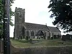 Church of St James |
| Church of St Mary | Fretherne, Fretherne with Saul, Stroud | Gate | 13th century | 10 January 1955 | SO7337209157 51°46′50″N 2°23′15″W / 51.780438°N 2.387384°W |
1154542 | _St_Mary's_Church_-_geograph.org.uk_-_68224.jpg.webp) Church of St Mary |
| Frocester Court | Frocester, Stroud | House | 18th century | 10 January 1955 | SO7873502930 51°43′29″N 2°18′33″W / 51.724682°N 2.309264°W |
1091169 | 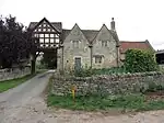 Frocester Court |
| Church of All Saints | Stone, Ham and Stone, Stroud | Church | 13th century | 30 March 1960 | ST6843795456 51°39′25″N 2°27′28″W / 51.656997°N 2.45767°W |
1274801 | 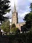 Church of All Saints |
| Manor Farmhouse and Gatepiers | Breadstone, Hamfallow, Stroud | Farmhouse | Medieval | 21 October 1952 | SO7146201282 51°42′34″N 2°24′52″W / 51.709541°N 2.41442°W |
1274485 | Upload Photo |
| Hardwicke Court | Hardwicke, Stroud | Country house | 1817-19 | 10 January 1955 | SO7878611712 51°48′13″N 2°18′33″W / 51.803642°N 2.309064°W |
1090815 | |
| Smith Monument in the Churchyard approx. 4m north of North Chapel to Church of St Nicholas | Hardwicke, Stroud | Chest Tomb | 1675 | 30 September 1985 | SO7936212446 51°48′37″N 2°18′03″W / 51.810263°N 2.300755°W |
1154188 | Upload Photo |
| Church of St John the Baptist | Harescombe, Stroud | Bell Tower | 13th century | 10 January 1955 | SO8373710416 51°47′32″N 2°14′14″W / 51.792157°N 2.237201°W |
1154223 | _St_John_the_Baptist's_Church_-_geograph.org.uk_-_524738.jpg.webp) Church of St John the Baptist |
| Hilles House and Terraced Gardens | Harescombe, Stroud | Country house | 1914-1939 | 10 January 1955 | SO8513012105 51°48′27″N 2°13′01″W / 51.807382°N 2.217077°W |
1090823 | Upload Photo |
| Mulberry Tree Hall and Garden Wall | Brookthorpe, Harescombe, Stroud | Detached House | Late 16th century or early 17th century | 10 January 1955 | SO8393012039 51°48′24″N 2°14′04″W / 51.806755°N 2.234478°W |
1154432 | Upload Photo |
| 3 unidentified Monuments, about 25m north-west of Tower in Churchyard of Church of St Peter | Haresfield Village, Haresfield, Stroud | Chest Tomb | Early 18th century | 9 December 1986 | SO8097410446 51°47′32″N 2°16′38″W / 51.792339°N 2.277263°W |
1303492 | Upload Photo |
| Church of St Peter | Haresfield Village, Haresfield, Stroud | Anglican Church | 12th century | 10 January 1955 | SO8099610421 51°47′32″N 2°16′37″W / 51.792115°N 2.276943°W |
1090521 | _St_Peter's_Church_-_geograph.org.uk_-_68229.jpg.webp) Church of St Peter |
| Harris, Four Niblett and Two unidentified Monuments, about 6m north of End of East Chancel in Churchyard of Church of St Peter | Haresfield Village, Haresfield, Stroud | Chest Tomb | Mid/late 17th century | 9 December 1986 | SO8102010425 51°47′32″N 2°16′36″W / 51.792152°N 2.276595°W |
1090525 | Upload Photo |
| Three unidentified Monuments, about 3m immediately East of Church Porch in Churchyard of Church of St Peter | Haresfield Village, Haresfield, Stroud | Chest Tomb | Late 17th century | 9 December 1986 | SO8100310410 51°47′31″N 2°16′37″W / 51.792016°N 2.276841°W |
1091319 | Upload Photo |
| Two unidentified Monuments, about 2m North East of Chancel in Churchyard of Church of St Peter | Haresfield Village, Haresfield, Stroud | Chest Tomb | Late 17th century | 9 December 1986 | SO8102610422 51°47′32″N 2°16′35″W / 51.792125°N 2.276508°W |
1155236 | Upload Photo |
| Burden Court Farmhouse and Gate Piers 10m to South West | Tresham, Hillesley and Tresham, Stroud | Farmhouse | Mid-late 17th century | 17 September 1952 | ST7959291002 51°37′03″N 2°17′46″W / 51.617469°N 2.296156°W |
1129383 | Upload Photo |
| Holwell Farmhouse | Ozleworth Bottom, Hillesley and Tresham, Stroud | Farmhouse | c. 1700 | 25 January 1978 | ST7931392437 51°37′49″N 2°18′01″W / 51.630361°N 2.300271°W |
1320842 | Upload Photo |
| Barton End Hall and Barton End House | Barton End, Horsley, Stroud | House | Mid-17th century | 24 March 1988 | ST8467698118 51°40′54″N 2°13′23″W / 51.681612°N 2.223041°W |
1171722 | Upload Photo |
| Church of St Martin | Horsley, Stroud | Anglican Church | 1838-9 | 28 June 1960 | ST8379598018 51°40′50″N 2°14′09″W / 51.680688°N 2.235779°W |
1305420 | 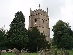 Church of St Martin |
| Group of 2 Monuments in the Churchyard Approx. 10m East of Chancel of St Martin | Horsley, Stroud | Tomb | Late 18th century and early 19th century | 24 March 1988 | ST8382398019 51°40′51″N 2°14′07″W / 51.680698°N 2.235374°W |
1305400 | Upload Photo |
| Unidentified Monument in the Churchyard approx. 20m south of South Transept to Church of St Martin | Horsley, Stroud | Chest Tomb | Early-mid 18th century | 24 March 1988 | ST8380697983 51°40′49″N 2°14′08″W / 51.680374°N 2.235618°W |
1091142 | Upload Photo |
| Court Farmhouse | King's Stanley, Stroud | Farmhouse | 15th century | 28 June 1960 | SO8147403276 51°43′40″N 2°16′11″W / 51.727891°N 2.269629°W |
1340638 | Upload Photo |
| Court House to North West of Court Farmhouse | King's Stanley, Stroud | Prison | Mid-18th century | 28 June 1960 | SO8145003290 51°43′41″N 2°16′12″W / 51.728016°N 2.269977°W |
1305424 | Upload Photo |
| Lych Gate to south of Church of All Saints | Selsley West, King's Stanley, Stroud | Lych Gate | 1862 | 24 February 1987 | SO8295603735 51°43′55″N 2°14′54″W / 51.732065°N 2.248195°W |
1305606 | .jpg.webp) Lych Gate to south of Church of All Saints |
| Old Castle House | King's Stanley, Stroud | House | 1563 | 28 June 1960 | SO8099803266 51°43′40″N 2°16′35″W / 51.727785°N 2.27652°W |
1340639 | Upload Photo |
| Former Mill Building at New Mills, west of Bushford Bridge | Kingswood, Stroud | Industrial Building | 1985 | 23 June 1952 | ST7375292971 51°38′06″N 2°22′50″W / 51.634929°N 2.380651°W |
1238004 | Upload Photo |
| New Inn House and Railings | Kingswood, Kingswood, Stroud | Abbey | c. 1495 | 9 September 1985 | ST7465692088 51°37′37″N 2°22′03″W / 51.627031°N 2.367526°W |
1238215 | Upload Photo |
| Former Saxon Church to west of Priory House and approx 10m South West of Church of St. Swithun | Leonard Stanley, Stroud | Barn | Saxon | 28 June 1960 | SO8020103245 51°43′39″N 2°17′17″W / 51.727568°N 2.288058°W |
1171503 | Upload Photo |
| Priory House | Leonard Stanley, Stroud | Farmhouse | Early to mid-17th century | 28 June 1960 | SO8023903234 51°43′39″N 2°17′15″W / 51.727471°N 2.287507°W |
1090735 | Upload Photo |
| The Mercers House, the Weavers Cottage and Vine Cottage | Leonard Stanley, Stroud | Cruck House | 15th century | 28 June 1960 | SO8024603396 51°43′44″N 2°17′15″W / 51.728928°N 2.287415°W |
1090701 | Upload Photo |
| Doris's Cottage | Epney, Longney and Epney, Stroud | Hall House | 15th century | 9 December 1986 | SO7638311229 51°47′57″N 2°20′38″W / 51.799203°N 2.343881°W |
1155549 | Upload Photo |
| Pack Monument in the Churchyard approx 3m west of Monument to Sarah Howsen; west of Church of St Lawrence | Longney Village, Longney and Epney, Stroud | Chest Tomb | Early 18th century | 30 September 1985 | SO7635712428 51°48′36″N 2°20′40″W / 51.809982°N 2.34434°W |
1090798 | Upload Photo |
| Arden House and Arden Cottage | Minchinhampton Town, Minchinhampton, Stroud | House | Early 16th century | 28 June 1960 | SO8720400735 51°42′19″N 2°11′12″W / 51.705206°N 2.186574°W |
1091107 | Upload Photo |
| Dunkirk Manor | Theescombe, Minchinhampton, Stroud | House | c. 1800 | 30 May 1951 | SO8463700635 51°42′15″N 2°13′25″W / 51.704242°N 2.223717°W |
1109670 | Upload Photo |
| Former Wool Stove at Bourne Mills | Minchinhampton, Stroud | Wool Stove | Early 19th century | 31 August 1988 | SO8723902103 51°43′03″N 2°11′10″W / 51.717506°N 2.186118°W |
1248837 | Upload Photo |
| Gatcombe Park | Minchinhampton, Stroud | Country house | 1771-74 | 28 June 1960 | ST8809499410 51°41′36″N 2°10′25″W / 51.693312°N 2.173649°W |
1091099 | |
| Greylands including Railings | Minchinhampton Town, Minchinhampton, Stroud | Town House | c. 1740 | 28 June 1960 | SO8718800714 51°42′18″N 2°11′12″W / 51.705017°N 2.186804°W |
1340462 | Upload Photo |
| Market House | Minchinhampton Town, Minchinhampton, Stroud | Market House | 1698 | 28 June 1960 | SO8725600749 51°42′19″N 2°11′09″W / 51.705333°N 2.185822°W |
1340484 | 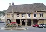 Market House |
| Old Mill Building at Longfords Mills | Avening Valley, Minchinhampton, Stroud | Mill | 1865 | 24 March 1988 | ST8666799211 51°41′29″N 2°11′39″W / 51.691491°N 2.194286°W |
1305339 | 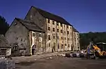 Old Mill Building at Longfords Mills |
| Seynckley House including Courtyard Walls | Minchinhampton, Stroud | Detached House | Late 15th century | 28 June 1960 | SO8431301912 51°42′57″N 2°13′42″W / 51.715714°N 2.228463°W |
1340457 | Upload Photo |
| St Marys House, Wing Cottage and Ivy Cottage | Minchinhampton, Stroud | House | Late 17th century | 28 June 1960 | SO8863602195 51°43′06″N 2°09′57″W / 51.718364°N 2.165899°W |
1091156 | Upload Photo |
| The Lammas | Minchinhampton Town, Minchinhampton, Stroud | Detached House | c. 1800 | 28 June 1960 | SO8708400627 51°42′15″N 2°11′18″W / 51.704232°N 2.188306°W |
1091088 | Upload Photo |
| Unidentified Monument in the Churchyard approx. 7m South West of South Transept to Church of the Holy Trinity | Minchinhampton Town, Minchinhampton, Stroud | Tomb | Mid-18th century | 24 March 1988 | SO8722100790 51°42′21″N 2°11′11″W / 51.705701°N 2.18633°W |
1340468 | Upload Photo |
| Church of St Andrew | Miserden Village, Miserden, Stroud | Parish Church | Mid-late 11th century | 28 June 1960 | SO9362308935 51°46′45″N 2°05′38″W / 51.779044°N 2.093836°W |
1091221 | _St_Andrew's_Church_-_geograph.org.uk_-_68342.jpg.webp) Church of St Andrew |
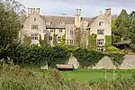
| Hazel Manor | Miserden, Stroud | Country house | c. 1680 | 28 June 1960 | SO9136609827 51°47′13″N 2°07′36″W / 51.787033°N 2.126573°W |
1091257 | Upload Photo |
| Miserden Park | Miserden Village, Miserden, Stroud | Country house | c. 1620 | 28 June 1960 | SO9409208928 51°46′44″N 2°05′13″W / 51.778986°N 2.087038°W |
1091226 | Upload Photo |
| Wishanger Farmhouse | Wishanger, Miserden, Stroud | House | Mid-late 16th century | 28 June 1960 | SO9207809478 51°47′02″N 2°06′58″W / 51.783906°N 2.116243°W |
1091227 | Upload Photo |
| Bannut Tree Chapel | Nailsworth, Stroud | House | Late 19th century | 30 May 1951 | ST8511399653 51°41′44″N 2°13′00″W / 51.695425°N 2.216786°W |
1299054 | Upload Photo |
| Bannut Tree House | Nailsworth, Stroud | Priests House | 16th century | 30 May 1951 | ST8510199663 51°41′44″N 2°13′01″W / 51.695515°N 2.21696°W |
1120871 | Upload Photo |
| Egypt House | Nailsworth, Stroud | House | 1698 | 17 July 1980 | ST8493899896 51°41′51″N 2°13′10″W / 51.697606°N 2.219329°W |
1186726 | Upload Photo |
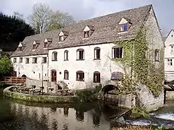
| Egypt Mill | Nailsworth, Stroud | Mill | 14th century | 17 July 1980 | ST8494699882 51°41′51″N 2°13′09″W / 51.69748°N 2.219212°W |
1120895 | |
| L-shaped Range of Buildings to Dunkirk Mills | Nailsworth, Stroud | Mill | 1741 | 10 March 1977 | SO8446000562 51°42′13″N 2°13′35″W / 51.70358°N 2.226275°W |
1120862 | Upload Photo |
| Spring Hill Court | Nailsworth, Stroud | House | 1680 | 30 May 1951 | ST8478799775 51°41′47″N 2°13′17″W / 51.696513°N 2.221508°W |
1186715 | Upload Photo |
| Spring Hill House | Nailsworth, Stroud | House | c. 1672 | 30 May 1951 | ST8481899747 51°41′47″N 2°13′16″W / 51.696263°N 2.221058°W |
1186714 | Upload Photo |
| Stokes Croft | Nailsworth, Stroud | House | Earlier origin | 30 May 1951 | ST8483699497 51°41′38″N 2°13′15″W / 51.694015°N 2.220787°W |
1186686 | Upload Photo |
| The Oaklands Farmhouse | Inchbrook, Nailsworth, Stroud | Farmhouse | c1730's-c1740's | 12 April 1979 | SO8412000803 51°42′21″N 2°13′52″W / 51.705738°N 2.231206°W |
1186694 | Upload Photo |
| Church of St Martin | North Nibley, Stroud | Church | 19th century | 30 June 1961 | ST7355796096 51°39′47″N 2°23′01″W / 51.663017°N 2.383706°W |
1221018 | 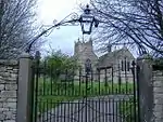 Church of St Martin |
| Doric Temple and Steps to Lakeside Pool | Stancombe Park, North Nibley, Stroud | Summerhouse | c. 1860 | 1 December 1986 | ST7390996864 51°40′12″N 2°22′43″W / 51.669938°N 2.378675°W |
1210685 |  Doric Temple and Steps to Lakeside Pool |
| Nibley House | North Nibley, Stroud | Country house | Mid-17th century | 23 June 1952 | ST7375495969 51°39′43″N 2°22′51″W / 51.661884°N 2.380848°W |
1210641 | .jpg.webp) Nibley House |
| Old Bournstream House | North Nibley, Stroud | Detached House | Late 16th century | 23 June 1952 | ST7485994438 51°38′53″N 2°21′53″W / 51.648169°N 2.364763°W |
1220982 | Upload Photo |
| Tyndale Monument with Railed Surround | North Nibley, Stroud | Tower | 1866 | 13 April 1984 | ST7432195628 51°39′32″N 2°22′21″W / 51.658844°N 2.372626°W |
1220938 | 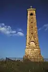 Tyndale Monument with Railed Surround |
| Unidentified Monument in the Churchyard approx. 7m north of Vestry to Church of St Martin | North Nibley, Stroud | Chest Tomb | Mid-18th century | 1 December 1986 | ST7357496112 51°39′47″N 2°23′00″W / 51.663161°N 2.383461°W |
1221046 | Upload Photo |
| Church of St Bartholomew | Nympsfield, Stroud | Anglican Church | 1861-63 | 30 June 1961 | SO8009700251 51°42′02″N 2°17′22″W / 51.700646°N 2.289392°W |
1091052 | _St_Bartholomew's_Church_-_geograph.org.uk_-_68357.jpg.webp) Church of St Bartholomew |
| Barn and attached Outbuildings at Tocknell's Court | Painswick, Stroud | Barn | Early 18th century | 24 August 1990 | SO8809611875 51°48′19″N 2°10′27″W / 51.805386°N 2.17405°W |
1091043 | Upload Photo |
| Brownshill Court | Painswick, Stroud | Apartment | 1955 | 21 October 1955 | SO8561107289 51°45′51″N 2°12′36″W / 51.764094°N 2.209899°W |
1091567 | Upload Photo |
| Cardynham | Tibbiwell Lane, Painswick, Stroud | Row House | 16th century | 21 October 1955 | SO8676709701 51°47′09″N 2°11′36″W / 51.785809°N 2.193242°W |
1091019 | 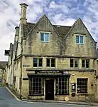 Cardynham |
| Castle Godwyn | Painswick, Stroud | Country house | Early to mid-18th century | 21 October 1955 | SO8709311649 51°48′12″N 2°11′19″W / 51.803331°N 2.188589°W |
1305033 | Upload Photo |
| Dover Cottage & Dover House | Painswick, Stroud | House | 1955 | 21 October 1955 | SO8698209748 51°47′10″N 2°11′24″W / 51.786237°N 2.190126°W |
1340217 | 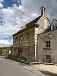 Dover Cottage & Dover House |
| Four Monuments in Churchyard circa 20m north of the north-east Corner of the Church of St Mary | Painswick, Stroud | Gravestone | 18th century | 24 August 1990 | SO8666809676 51°47′08″N 2°11′41″W / 51.785582°N 2.194676°W |
1340541 | Upload Photo |
| Gothic seat circa 150m south west of Painswick House | Painswick, Stroud | Loggia | c. 1750 | 24 August 1990 | SO8618810379 51°47′31″N 2°12′06″W / 51.791891°N 2.201662°W |
1153492 | 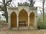 Gothic seat circa 150m south west of Painswick House |
| Group of 8 Packer and Other Monuments in the Churchyard circa 12 to 25m South of North Gate to the Church of St Mary | Painswick, Stroud | Tomb | 1733 | 24 August 1990 | SO8666209686 51°47′08″N 2°11′41″W / 51.785672°N 2.194763°W |
1090962 | Upload Photo |
| Group of Eight Monuments circa 12m east of East Chancel Wall in the Churchyard of the Church of St Mary | Painswick, Stroud | Gravestone | Late 17th century | 24 August 1990 | SO8669209651 51°47′07″N 2°11′40″W / 51.785358°N 2.194327°W |
1153228 | Upload Photo |
| Holcombe House | Holcombe, Painswick, Stroud | Country house | C16/C17 | 21 October 1955 | SO8578911554 51°48′09″N 2°12′27″W / 51.802445°N 2.207496°W |
1152444 | |
| John Bryan Monument circa 25m in the Churchyard south-east of Lych Gate to the Church of St Mary | Churchyard of St Mary's, Painswick, Stroud | Commemorative Monument | 1787 | 24 August 1990 | SO8660309618 51°47′06″N 2°11′44″W / 51.785059°N 2.195616°W |
1340527 | 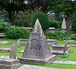 John Bryan Monument circa 25m in the Churchyard south-east of Lych Gate to the Church of St Mary |
| Loveday and unidentified Monuments circa 5m east of East Chancel Wall in the Churchyard of the Church of St Mary | Painswick, Stroud | Gravestone | Early 17th century | 24 August 1990 | SO8668809645 51°47′07″N 2°11′40″W / 51.785304°N 2.194385°W |
1090966 | Upload Photo |
| Millers House | Painswick, Stroud | Row House | 17th century | 21 October 1955 | SO8679709768 51°47′11″N 2°11′34″W / 51.786412°N 2.192809°W |
1091049 | Upload Photo |
| New Hall | Painswick, Stroud | House | 15th century | 24 August 1990 | SO8675309816 51°47′13″N 2°11′36″W / 51.786843°N 2.193449°W |
1151979 | 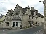 New Hall |
| Pigeon House at Painswick House | Painswick, Stroud | Dovecote | Mid-18th century | 24 August 1990 | SO8630210301 51°47′28″N 2°12′00″W / 51.791192°N 2.200007°W |
1090941 | 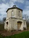 Pigeon House at Painswick House |
| Ram House circa 30m south-east of Plunge Pool, Painswick House | Painswick, Stroud | House | c. 1750 | 24 August 1990 | SO8627110536 51°47′36″N 2°12′02″W / 51.793305°N 2.200465°W |
1090944 | Upload Photo |
| Eagle House circa 25m west of the Stables | Painswick, Stroud | Garden Building | c. 1750 | 24 August 1990 | SO8635510522 51°47′35″N 2°11′57″W / 51.793181°N 2.199247°W |
1340532 | 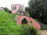 Eagle House circa 25m west of the Stables |
| Spring Head and Pool circa 150m west of the Stables, Painswick House | Painswick, Stroud | Trough | c. 1750 | 24 August 1990 | SO8624910560 51°47′37″N 2°12′03″W / 51.79352°N 2.200785°W |
1304279 | Upload Photo |
| Statue of Pan circa 35m south-east of the Stables, Painswick House | Painswick, Stroud | Statue | Mid-18th century | 24 August 1990 | SO8643410499 51°47′35″N 2°11′53″W / 51.792976°N 2.1981°W |
1153446 | 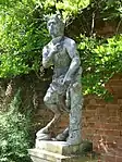 Statue of Pan circa 35m south-east of the Stables, Painswick House |
| The Red House circa 150m north of the Stables, Painswick House | Painswick, Stroud | Garden Building | c. 1750 | 24 August 1990 | SO8642610665 51°47′40″N 2°11′54″W / 51.794468°N 2.198223°W |
1304275 | 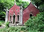 The Red House circa 150m north of the Stables, Painswick House |
| Urn circa 30m west of Stable Block at Painswick House | Painswick, Stroud | Urn | 18th century | 24 August 1990 | SO8634810506 51°47′35″N 2°11′58″W / 51.793037°N 2.199348°W |
1304306 |  Urn circa 30m west of Stable Block at Painswick House |
| Classical Seat circa 150m north-west of the Stables, Painswick House | Painswick, Stroud | Garden seat | c. 1750 | 24 August 1990 | SO8629710642 51°47′39″N 2°12′00″W / 51.794258°N 2.200093°W |
1340531 | Upload Photo |
| Well Head circa 35m south-west of the Classical Seat, Painswick House | Painswick, Stroud | Well Head | c. 1750 | 24 August 1990 | SO8627610618 51°47′39″N 2°12′01″W / 51.794042°N 2.200396°W |
1090943 | Upload Photo |
| Urn circa 6m South of South East Corner of Painswick House | Painswick, Stroud | Urn | 18th century | 24 August 1990 | SO8634610450 51°47′33″N 2°11′58″W / 51.792533°N 2.199374°W |
1340530 | Upload Photo |
| The Cottage & Wick Street House | Painswick, Stroud | Detached house | 1633 | 21 October 1955 | SO8612007639 51°46′02″N 2°12′09″W / 51.767254°N 2.202538°W |
1223902 | Upload Photo |
| The Gables | Painswick, Stroud | House | 16th century | 21 October 1955 | SO8673409726 51°47′10″N 2°11′37″W / 51.786033°N 2.193721°W |
1152180 | 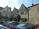 The Gables |
| The Post Office and the Beehive | Painswick, Stroud | Row | 16th century | 21 October 1955 | SO8666709768 51°47′11″N 2°11′41″W / 51.786409°N 2.194694°W |
1152581 | 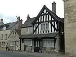 The Post Office and the Beehive |
| The Sheephouse | Painswick, Stroud | Farmhouse | Early 17th century | 21 October 1955 | SO8591308529 51°46′31″N 2°12′20″W / 51.775251°N 2.205574°W |
1091042 | 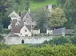 The Sheephouse |
| Tocknells Court | Painswick, Stroud | Country house | c. 1570 | 21 October 1955 | SO8813011885 51°48′20″N 2°10′25″W / 51.805476°N 2.173558°W |
1340504 | Upload Photo |
| Well Farmhouse | Painswick, Stroud | Farmhouse | Mid-17th century | 21 October 1955 | SO8651007928 51°46′12″N 2°11′49″W / 51.769862°N 2.196898°W |
1267087 | Upload Photo |
| Yew Tree House | Painswick, Stroud | Detached House | 1670 | 21 October 1955 | SO8695509728 51°47′10″N 2°11′26″W / 51.786056°N 2.190517°W |
1340199 | 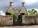 Yew Tree House |
| Group of 9 Monuments in the Churchyard adjacent to South Side of Nave and Chancel to Church of St John the Baptist | Pitchcombe, Stroud | Sarcophagus | 1846 | 24 March 1987 | SO8515808249 51°46′22″N 2°12′59″W / 51.772714°N 2.216505°W |
1302874 | Upload Photo |
| Pitchcombe House | Pitchcombe Village, Pitchcombe, Stroud | Country house | c. 1740 | 28 June 1960 | SO8491008076 51°46′16″N 2°13′12″W / 51.771151°N 2.220091°W |
1340411 | 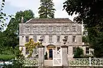 Pitchcombe House |
| More Hall Convent | Randwick, Stroud | Courtyard House | 1582 | 28 June 1960 | SO8300706090 51°45′12″N 2°14′51″W / 51.75324°N 2.247572°W |
1340392 | 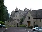 More Hall Convent |
| Church of St Mary Magdalene; Gates and Wall on West and North Sides of Churchyard | Rodborough, Rodborough, Stroud | Church | Mid-19th century | 1 May 1951 | SO8432804413 51°44′18″N 2°13′42″W / 51.738201°N 2.228359°W |
1340958 | 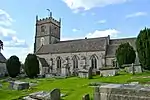 Church of St Mary Magdalene; Gates and Wall on West and North Sides of Churchyard |
| Dudbridge House | Dudbridge, Rodborough, Stroud | House | Mid-18th century | 5 April 1973 | SO8349904389 51°44′17″N 2°14′25″W / 51.737962°N 2.240363°W |
1267466 | Upload Photo |
| Garth | Rodborough, Rodborough, Stroud | House | 17th century | 1 May 1951 | SO8445004073 51°44′07″N 2°13′36″W / 51.735148°N 2.226577°W |
1239609 | Upload Photo |
| Sunnyside | Rodborough, Rodborough, Stroud | House | 17th century | 1 May 1951 | SO8443904051 51°44′06″N 2°13′36″W / 51.73495°N 2.226735°W |
1273622 | Upload Photo |
| Vale View | Rodborough, Rodborough, Stroud | House | 17th century | 1 May 1951 | SO8445204059 51°44′06″N 2°13′36″W / 51.735022°N 2.226548°W |
1273594 | Upload Photo |
| 47 Kingscourt Lane | Rodborough, Rodborough, Stroud | House | 17th century | 1 May 1951 | SO8443604030 51°44′05″N 2°13′36″W / 51.734761°N 2.226778°W |
1239680 | Upload Photo |
| Unidentified Chest Tomb circa 2.5m south of South Tower Wall, at Church of St John the Evangelist | Slimbridge, Stroud | Chest Tomb | late C17-early 18th century | 26 April 1984 | SO7402603556 51°43′48″N 2°22′39″W / 51.730111°N 2.377484°W |
1340551 | Upload Photo |
| Unidentified Chest Tomb circa 5m east of South Porch Door of Church of St John the Evangelist | Slimbridge, Stroud | Chest Tomb | Early 18th century | 26 April 1984 | SO7403903549 51°43′48″N 2°22′38″W / 51.730049°N 2.377295°W |
1090899 | Upload Photo |
| Almory Gateway or Gatehouse | Standish Village, Standish, Stroud | Gate | 14th century | 10 January 1955 | SO8001808439 51°46′27″N 2°17′28″W / 51.774261°N 2.291008°W |
1303211 | 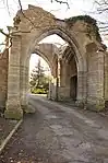 Almory Gateway or Gatehouse |
| Niblett Monument, about 3m east of Dowdeswell Monument in Churchyard of Church of St Nicholas | Standish Village, Standish, Stroud | Chest Tomb | 1676 | 9 December 1986 | SO8008608427 51°46′27″N 2°17′24″W / 51.774155°N 2.290021°W |
1340370 | Upload Photo |
| Church of St Cyr | Stinchcombe, Stroud | Parish Church | 15th century | 30 June 1961 | ST7296598865 51°41′16″N 2°23′33″W / 51.687884°N 2.39248°W |
1340554 | 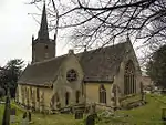 Church of St Cyr |
| Drakestones House and attached Stable Block and Walls | Stinchcombe, Stroud | House | 1911 | 26 April 1984 | ST7344797789 51°40′42″N 2°23′08″W / 51.678233°N 2.385426°W |
1340581 | Upload Photo |
| Joseph Hicks Chest Tomb, 2.5m north of North Porch Entrance to Church of St Cyr | Stinchcombe, Stroud | Chest Tomb | 1739 | 26 April 1984 | ST7296398876 51°41′17″N 2°23′33″W / 51.687983°N 2.39251°W |
1090907 | Upload Photo |
| Joseph Hicks Chest Tomb, circa 4m north of North Porch Entrance to Church of St Cyr | Stinchcombe, Stroud | Chest Tomb | 1728 | 26 April 1984 | ST7296298878 51°41′17″N 2°23′33″W / 51.688001°N 2.392525°W |
1305726 | Upload Photo |
| Melksham Court | Stinchcombe, Stroud | Manor House | 16th century | 23 June 1952 | ST7348798712 51°41′12″N 2°23′06″W / 51.686534°N 2.384918°W |
1171311 | Upload Photo |
| Piers Court | Stinchcombe, Stroud | House | 16th century | 2 June 1952 | ST7332198737 51°41′12″N 2°23′14″W / 51.686751°N 2.387321°W |
1305626 | Upload Photo |
| Unidentified Chest Tomb circa 5.5m north of North Porch Entrance to Church of St Cyr | Stinchcombe, Stroud | Chest Tomb | Early 18th century | 26 April 1984 | ST7296198880 51°41′17″N 2°23′33″W / 51.688019°N 2.392539°W |
1090908 | Upload Photo |
| William Bendall Chest Tomb circa 8m north-east of Porch to Church of St Cyr | Stinchcombe, Stroud | Chest Tomb | Mid-18th century | 26 April 1984 | ST7296498880 51°41′17″N 2°23′33″W / 51.688019°N 2.392496°W |
1171187 | Upload Photo |
| Church of St Cyr | Stonehouse, Stroud | Parish Church | 14th century | 28 June 1960 | SO7994905013 51°44′36″N 2°17′31″W / 51.743455°N 2.291809°W |
1340646 | 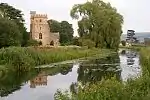 Church of St Cyr |
| Group of 12 Monuments in the Churchyard approx between 5 and 20m to north of Porch to Church of St Cyr | Stonehouse, Stroud | Chest Tomb | 1653 | 24 February 1987 | SO7995605033 51°44′37″N 2°17′30″W / 51.743635°N 2.291709°W |
1305404 | Upload Photo |
| Stonehouse Court Hotel | Stonehouse, Stroud | Country house | 1601 | 28 June 1960 | SO7990805099 51°44′39″N 2°17′33″W / 51.744227°N 2.292408°W |
1340682 | |
| Archway, formerly to Farm Hill Park | Paganhill, Stroud, Stroud | Arch | 1834 | 1 May 1951 | SO8379205764 51°45′01″N 2°14′10″W / 51.750333°N 2.236185°W |
1274282 | 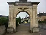 Archway, formerly to Farm Hill Park |
| Church of St Laurence | Stroud, Stroud | Bell Tower | 14th century | 1 May 1951 | SO8522605274 51°44′45″N 2°12′55″W / 51.745967°N 2.215392°W |
1267652 | 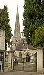 Church of St Laurence |
| Lodgemoor Mills Office Block | Stroud, Stroud | Mill | 17th century | 1 May 1951 | SO8434005008 51°44′37″N 2°13′42″W / 51.743551°N 2.228212°W |
1239615 | 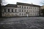 Lodgemoor Mills Office Block |
| Railway Goods Shed and Offices | Stroud, Stroud | Goods Shed | c. 1845 | 30 June 1989 | SO8508205022 51°44′37″N 2°13′03″W / 51.743698°N 2.217466°W |
1267258 |  Railway Goods Shed and Offices |
| Slade House | Stroud, Stroud | House | Early to mid-18th century | 1 May 1951 | SO8649305573 51°44′55″N 2°11′49″W / 51.748688°N 2.197052°W |
1267454 | Upload Photo |
| The Fields | Stroud, Stroud | House | 17th century | 1 May 1951 | SO8583304806 51°44′30″N 2°12′24″W / 51.741775°N 2.20658°W |
1090092 | Upload Photo |
| Town Hall | Stroud, Stroud | Town Hall | 1596 | 25 June 1974 | SO8522505229 51°44′44″N 2°12′55″W / 51.745563°N 2.215404°W |
1267688 | |
| Angeston Grange | Uley, Stroud | House | Early 19th century | 26 April 1984 | ST7816998106 51°40′53″N 2°19′02″W / 51.681288°N 2.317154°W |
1171418 | Upload Photo |
| Bencombe House | Uley, Stroud | Clothiers House | Early 18th century | 23 June 1952 | ST7921997563 51°40′35″N 2°18′07″W / 51.676446°N 2.301935°W |
1171515 | Upload Photo |
| Church of St Giles | Uley, Stroud | Parish Church | 1857-1858 | 30 June 1961 | ST7912398570 51°41′08″N 2°18′12″W / 51.685496°N 2.303384°W |
1090858 | 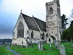 Church of St Giles |
| Coombe House | Uley, Stroud | Clothiers House | 1728 | 23 June 1952 | ST7847097965 51°40′48″N 2°18′46″W / 51.680032°N 2.312792°W |
1171443 | Upload Photo |
| Dimery Tomb circa 11m south-west of South West Corner, at Church of St Giles | Uley, Stroud | Altar Tomb | Early 19th century | 26 April 1984 | ST7910298559 51°41′07″N 2°18′13″W / 51.685396°N 2.303687°W |
1172079 | Upload Photo |
| Stoutshill | Uley, Stroud | House | 1952 | 23 June 1952 | ST7871297770 51°40′42″N 2°18′33″W / 51.678288°N 2.30928°W |
1340605 | Upload Photo |
| Uley Lodge | Uley, Stroud | Clothiers House | 1612 | 23 June 1952 | ST7919898735 51°41′13″N 2°18′08″W / 51.686982°N 2.302309°W |
1090888 | Upload Photo |
| Unidentified Chest Tomb circa 10m west of South West Corner, at Church of St Giles | Uley, Stroud | Chest Tomb | Early 18th century | 26 April 1984 | ST7910298565 51°41′08″N 2°18′13″W / 51.68545°N 2.303687°W |
1172072 | Upload Photo |
| Unidentified Memorial, circa 7m south-west of South West Corner at Church of St Giles | Uley, Stroud | Tomb | 1672 | 26 April 1984 | ST7910498559 51°41′07″N 2°18′13″W / 51.685396°N 2.303658°W |
1305283 | Upload Photo |
| Wresden Farmhouse, Mill and attached Barn | Uley, Stroud | Farmhouse | 1984 | 23 June 1952 | ST7721698027 51°40′50″N 2°19′51″W / 51.680539°N 2.330933°W |
1340583 | Upload Photo |
| 49, The Street | Uley, Stroud | Clothiers House | 17th century | 30 June 1961 | ST7895398438 51°41′03″N 2°18′21″W / 51.684303°N 2.305835°W |
1090857 | Upload Photo |
| Barn to North West of Manor Farmhouse | Upton St. Leonards, Stroud | Stable | Late 17th century | 10 January 1955 | SO8710914132 51°49′32″N 2°11′18″W / 51.825656°N 2.18845°W |
1090745 | Upload Photo |
| Church of St Leonard | Upton St. Leonards, Stroud | Parish Church | Late 13th century | 10 January 1955 | SO8621614943 51°49′59″N 2°12′05″W / 51.832926°N 2.20144°W |
1154810 | 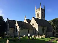 Church of St Leonard |
| Monument to Richard Ockold in the Churchyard approx 3m south of South Aisle to Church of St Leonard | Upton St. Leonards, Stroud | Chest Tomb | 1689 | 30 September 1985 | SO8619414938 51°49′58″N 2°12′06″W / 51.832881°N 2.201759°W |
1154902 | Upload Photo |
| Monument to Richard Ockold in the Churchyard approx 4.5m south of South Aisle to Church of St Leonard | Upton St. Leonards, Stroud | Chest Tomb | 1657 | 30 September 1985 | SO8619214935 51°49′58″N 2°12′06″W / 51.832854°N 2.201788°W |
1247880 | Upload Photo |
| Church of St Andrew | Wheatenhurst, Whitminster, Stroud | Anglican Church | 14th century | 10 January 1955 | SO7603009069 51°46′47″N 2°20′56″W / 51.779768°N 2.34885°W |
1303052 | |
| Whitminster House | Wheatenhurst, Whitminster, Stroud | Country house | 1867 | 10 January 1955 | SO7597409050 51°46′47″N 2°20′59″W / 51.779594°N 2.34966°W |
1156110 | Upload Photo |
| Atcombe Court | South Woodchester, Woodchester, Stroud | Country house | Late 17th century | 28 June 1960 | SO8373301720 51°42′50″N 2°14′13″W / 51.713971°N 2.236849°W |
1340672 | Upload Photo |
| Church of St Mary | North Woodchester, Woodchester, Stroud | Parish Church | 1863-1864 | 24 February 1987 | SO8397902670 51°43′21″N 2°14′00″W / 51.72252°N 2.233333°W |
1090669 | 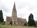 Church of St Mary |
| Rooksmoor House | Woodchester, Stroud | House | Mid-16th century | 28 June 1960 | SO8422203167 51°43′37″N 2°13′47″W / 51.726995°N 2.229837°W |
1090718 | Upload Photo |
| Southfield House | Woodchester, Stroud | Detached House | Late 16th century | 28 June 1960 | SO8418702559 51°43′18″N 2°13′49″W / 51.721528°N 2.230316°W |
1172364 | Upload Photo |
| Woodchester House | Woodchester, Stroud | Country house | Mid-18th century | 28 June 1960 | SO8392602376 51°43′12″N 2°14′03″W / 51.719875°N 2.234086°W |
1090664 | Upload Photo |
| Bradley Court | Wotton-under-Edge, Stroud | Manor House | 1568 | 23 June 1952 | ST7456593720 51°38′30″N 2°22′08″W / 51.641701°N 2.368959°W |
1341521 | Upload Photo |
| Royal Oak | Wotton-under-Edge, Stroud | Inn | 17th century | 23 June 1952 | ST7552293320 51°38′17″N 2°21′18″W / 51.638147°N 2.355102°W |
1088922 | 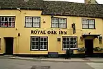 Royal Oak |
| The Ancient Ram Inn | Wotton-under-Edge, Stroud | First Floor Hall House | Late Medieval | 23 June 1952 | ST7601893299 51°38′17″N 2°20′53″W / 51.63798°N 2.347933°W |
1088885 | 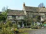 The Ancient Ram Inn |
| The Court | Wotton-under-Edge, Stroud | House | Early 18th century | 16 August 1984 | ST7593893380 51°38′19″N 2°20′57″W / 51.638704°N 2.349095°W |
1088914 | Upload Photo |
| Wortley House | Wortley, Wotton-under-Edge, Stroud | Kitchen | Early 18th century | 16 August 1984 | ST7657691796 51°37′28″N 2°20′23″W / 51.62449°N 2.339769°W |
1341598 | Upload Photo |
| 13 Market Street | Wotton-under-Edge, Stroud | Timber-framed house | 16th century or earlier | 23 June 1952 | ST7559393256 51°38′15″N 2°21′15″W / 51.637575°N 2.354071°W |
1088870 | Upload Photo |
_St_Margaret's_Church_-_geograph.org.uk_-_68396.jpg.webp)
_St_Swithin's_Church_-_geograph.org.uk_-_68202.jpg.webp)
.jpg.webp)
Notes
- ↑ The date given is the date used by Historic England as significant for the initial building or that of an important part in the structure's description.
- ↑ Sometimes known as OSGB36, the grid reference is based on the British national grid reference system used by the Ordnance Survey.
- ↑ The "List Entry Number" is a unique number assigned to each listed building and scheduled monument by Historic England.
External links
This article is issued from Wikipedia. The text is licensed under Creative Commons - Attribution - Sharealike. Additional terms may apply for the media files.