Dampierre-lès-Conflans | |
|---|---|
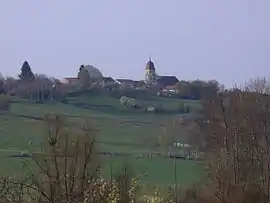 A general view of Dampierre-lès-Conflans | |
Location of Dampierre-lès-Conflans | |
 Dampierre-lès-Conflans 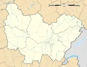 Dampierre-lès-Conflans | |
| Coordinates: 47°50′56″N 6°11′09″E / 47.8489°N 6.1858°E | |
| Country | France |
| Region | Bourgogne-Franche-Comté |
| Department | Haute-Saône |
| Arrondissement | Lure |
| Canton | Port-sur-Saône |
| Government | |
| • Mayor (2020–2026) | Ghislain Jacquey[1] |
| Area 1 | 10.37 km2 (4.00 sq mi) |
| Population | 252 |
| • Density | 24/km2 (63/sq mi) |
| Time zone | UTC+01:00 (CET) |
| • Summer (DST) | UTC+02:00 (CEST) |
| INSEE/Postal code | 70196 /70800 |
| Elevation | 227–328 m (745–1,076 ft) |
| 1 French Land Register data, which excludes lakes, ponds, glaciers > 1 km2 (0.386 sq mi or 247 acres) and river estuaries. | |
Dampierre-lès-Conflans (French pronunciation: [dɑ̃pjɛʁ lɛ kɔ̃flɑ̃], literally Dampierre near Conflans) is a commune in the Haute-Saône department in the region of Bourgogne-Franche-Comté in eastern France.
Twin towns
 Roccagiovine, Italy
See also
References
- ↑ "Répertoire national des élus: les maires" (in French). data.gouv.fr, Plateforme ouverte des données publiques françaises. 16 December 2022.
- ↑ "Populations légales 2021". The National Institute of Statistics and Economic Studies. 28 December 2023.
Wikimedia Commons has media related to Dampierre-lès-Conflans.
This article is issued from Wikipedia. The text is licensed under Creative Commons - Attribution - Sharealike. Additional terms may apply for the media files.