Wald (Allgäu)
Wald is a municipality in Ostallgäu in Bavaria in Germany.
Wald | |
|---|---|
 General view of Wald | |
_COA.svg.png.webp) Coat of arms | |
Location of Wald (Allgäu) within Ostallgäu district 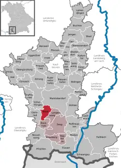 | |
 Wald  Wald | |
| Coordinates: 47°43′N 10°33′E | |
| Country | Germany |
| State | Bavaria |
| Admin. region | Schwaben |
| District | Ostallgäu |
| Government | |
| • Mayor (2020–26) | Johanna Purschke[1] |
| Area | |
| • Total | 17.97 km2 (6.94 sq mi) |
| Elevation | 800 m (2,600 ft) |
| Population (2022-12-31)[2] | |
| • Total | 1,175 |
| • Density | 65/km2 (170/sq mi) |
| Time zone | UTC+01:00 (CET) |
| • Summer (DST) | UTC+02:00 (CEST) |
| Postal codes | 87616 |
| Dialling codes | 09463 |
| Vehicle registration | OAL |
| Website | www.wald-allgaeu.de |
The village Wald is in the Allgäu region. Wald belongs to the administrative community Seeg and is in Bavarian Swabia.
Wald includes many surrounding hamlets: Barnstein, Bergers, Birngschwend, Geigers, Gemmels, houses, Herring, Hofen, Holzmanns, Kaltenbrunn, Kaufmanns, Kippach, Klosterhof, Neupolz, Öbele, Ofen, Stechele, Wetzlers, Wies, Wimberg.
Sights
 Weiher (ponds) of Wald
 Wald from the air from the southeast
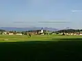 Wald from northwest
 Wertachschlucht near Wald
 Wald - Church tower after fire, January 2012
 Wald at night, December 2012
Other websites
Wikimedia Commons has media related to Wald (Allgäu).
References
- Liste der ersten Bürgermeister/Oberbürgermeister in kreisangehörigen Gemeinden, Bayerisches Landesamt für Statistik, 15 July 2021.
- Genesis Online-Datenbank des Bayerischen Landesamtes für Statistik Tabelle 12411-003r Fortschreibung des Bevölkerungsstandes: Gemeinden, Stichtag (Einwohnerzahlen auf Grundlage des Zensus 2011) .
Towns and municipalities in Ostallgäu | ||
|---|---|---|
| Coat of Arms of Ostallgäu district | |
This article is issued from Wikipedia. The text is licensed under Creative Commons - Attribution - Sharealike. Additional terms may apply for the media files.