Aitrang
Aitrang is a municipality in Ostallgäu in Bavaria in Germany.
Aitrang | |
|---|---|
 Aitrang seen from the southeast | |
 Coat of arms | |
Location of Aitrang within Ostallgäu district 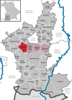 | |
 Aitrang  Aitrang | |
| Coordinates: 47°49′N 10°32′E | |
| Country | Germany |
| State | Bavaria |
| Admin. region | Schwaben |
| District | Ostallgäu |
| Government | |
| • Mayor (2020–26) | Michael Hailand[1] |
| Area | |
| • Total | 30.71 km2 (11.86 sq mi) |
| Elevation | 745 m (2,444 ft) |
| Population (2022-12-31)[2] | |
| • Total | 2,088 |
| • Density | 68/km2 (180/sq mi) |
| Time zone | UTC+01:00 (CET) |
| • Summer (DST) | UTC+02:00 (CEST) |
| Postal codes | 87648 |
| Dialling codes | 08343 |
| Vehicle registration | OAL |
| Website | www.aitrang.de |
Geography
Aitrang is in the south Bavarian Region Allgäu.
It surrounds districts of: Aitrang, Huttenwang, Wenglingen. Administrative responsibility also extends to the distant villages of Binnings, Goerwangs, Krähberg, Neuenried, Wolfholz, Münzenried and Umwangs as well as several Farms. Aitrang also covers the Eibsee (lake).
Picture Gallery
 Pfarrkirche St.Ulrich
 Sehenswertes Giebelfries
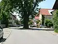 Ortsmitte mit Linde
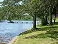 Elbsee südlich von Aitrang
References
- Liste der ersten Bürgermeister/Oberbürgermeister in kreisangehörigen Gemeinden, Bayerisches Landesamt für Statistik, 15 July 2021.
- Genesis Online-Datenbank des Bayerischen Landesamtes für Statistik Tabelle 12411-003r Fortschreibung des Bevölkerungsstandes: Gemeinden, Stichtag (Einwohnerzahlen auf Grundlage des Zensus 2011) .
Other websites
Wikimedia Commons has media related to Aitrang.
- Website of the municipality Aitrang
- Warburg Institute Iconographic Database (images of the interior of St Alban's church) Archived 2016-03-04 at the Wayback Machine
Towns and municipalities in Ostallgäu | ||
|---|---|---|
| Coat of Arms of Ostallgäu district | |
This article is issued from Wikipedia. The text is licensed under Creative Commons - Attribution - Sharealike. Additional terms may apply for the media files.