Vöhringen, Bavaria
Vöhringen is a town in Neu-Ulm in Bavaria, Germany. It is on the Iller, about 18 km south of Ulm and 40 km north of Memmingen. It is in the Donau-Iller Region in Central Swabia (part of Upper Swabia).
Vöhringen | |
|---|---|
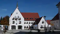 Town hall | |
 Coat of arms | |
Location of Vöhringen within Neu-Ulm district _in_NU.svg.png.webp) | |
 Vöhringen  Vöhringen | |
| Coordinates: 48°17′N 10°05′E | |
| Country | Germany |
| State | Bavaria |
| Admin. region | Schwaben |
| District | Neu-Ulm |
| Government | |
| • Mayor (2020–26) | Michael Neher[1] (CSU) |
| Area | |
| • Total | 23.63 km2 (9.12 sq mi) |
| Elevation | 499 m (1,637 ft) |
| Population (2022-12-31)[2] | |
| • Total | 13,933 |
| • Density | 590/km2 (1,500/sq mi) |
| Time zone | UTC+01:00 (CET) |
| • Summer (DST) | UTC+02:00 (CEST) |
| Postal codes | 89269 |
| Dialling codes | 07306, 07307 (Illerzell) |
| Vehicle registration | NU |
| Website | www.voehringen.de |
Neighbouring municipalities
- Senden to the north
- Weißenhorn to the east
- Bellenberg to the south
- Illerrieden, Baden-Württemberg, to the west
Illerzell
The formerly settlement of Illerzell, is about 3 km northwest of Vöhringen on the floor of the Iller Valley. It was incorporated into Vöhringen on 1 July 1972.
Illerberg und Thal
Illerberg, and Thal, are placed about 2 km east of Vöhringen and are still largely agricultural villages. In existence since the 6th or 7th centuries, they were long allied under a single overlord and have grown together to form a single settlement; the two were administratively united on 22 November 1970 and were incorporated into Vöhringen on 1 January 1976.[3]
References
- Liste der ersten Bürgermeister/Oberbürgermeister in kreisangehörigen Gemeinden, Bayerisches Landesamt für Statistik, 15 July 2021.
- Genesis Online-Datenbank des Bayerischen Landesamtes für Statistik Tabelle 12411-003r Fortschreibung des Bevölkerungsstandes: Gemeinden, Stichtag (Einwohnerzahlen auf Grundlage des Zensus 2011) .
- Festschrift: 150 Jahre Musikkappelle Illerberg/Thal, 2004, p. 14 (pdf) (in German)
Sources
- Reinhard H. Seitz. Vöhringen - Bilder und Miniaturen einer jungen Stadt. Weißenhorn: Konrad, 2002. ISBN 978-3-87437-462-0
Other websites
Gallery
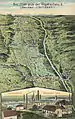 Aerial view of the Iller Valley and view of the Wieland Works: early 20th-century postcard
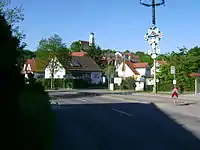
.jpg.webp) Illerberg
Illerberg
Towns and municipalities in Neu-Ulm (district) | ||
|---|---|---|