Uttenreuth
Uttenreuth is a town in the district of Erlangen-Höchstadt in Bavaria in Germany.
Uttenreuth | |
|---|---|
 Protestant Church of Saint Matthew | |
 Coat of arms | |
Location of Uttenreuth within Erlangen-Höchstadt district 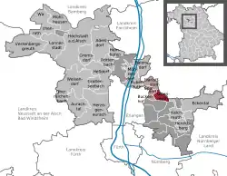 | |
 Uttenreuth  Uttenreuth | |
| Coordinates: 49°36′N 11°4′E | |
| Country | Germany |
| State | Bavaria |
| Admin. region | Mittelfranken |
| District | Erlangen-Höchstadt |
| Municipal assoc. | Uttenreuth |
| Subdivisions | 2 districts |
| Government | |
| • Mayor (2020–26) | Frederic Ruth[1] |
| Area | |
| • Total | 5.93 km2 (2.29 sq mi) |
| Elevation | 291 m (955 ft) |
| Population (2022-12-31)[2] | |
| • Total | 5,070 |
| • Density | 850/km2 (2,200/sq mi) |
| Time zone | UTC+01:00 (CET) |
| • Summer (DST) | UTC+02:00 (CEST) |
| Postal codes | 91080 |
| Vehicle registration | ERH |
| Website | www.uttenreuth.de |
Geography
Geographical place
Uttenreuth is about 5-kilometer (3.1 mi) east of Erlangen in the Schwabach valley.
Neighboring communities
Towns neighboring Uttenreuth are Dormitz (in the East), Neunkirchen am Brand (Northeast), Marloffstein (North), Spardorf (Northwest) and Buckenhof in the West. To the South, Uttenreuth borders a large forest, the Sebalder Reichswald.
Subdivisions
- Uttenreuth
- Weiher (unified in 1978)
Literature
- Paulus, Erich and Regina Paulus. 2001. Uttenreuth - Geschichtsbuch über ein fränkisches Dorf am Rande der Stadt. ISBN 3-87707-576-2
References
- Liste der ersten Bürgermeister/Oberbürgermeister in kreisangehörigen Gemeinden, Bayerisches Landesamt für Statistik, 15 July 2021.
- Genesis Online-Datenbank des Bayerischen Landesamtes für Statistik Tabelle 12411-003r Fortschreibung des Bevölkerungsstandes: Gemeinden, Stichtag (Einwohnerzahlen auf Grundlage des Zensus 2011) .
Other websites
- Official website (German)
Towns and municipalities in Erlangen-Höchstadt | ||
|---|---|---|
Coat of Arms of Erlangen-Höchstadt district | ||
This article is issued from Wikipedia. The text is licensed under Creative Commons - Attribution - Sharealike. Additional terms may apply for the media files.