Salcedo, Dominican Republic
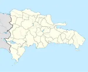
The Dominican city of Salcedo is the head municipality of the Hermanas Mirabal province, on the central part of the country.
Salcedo | |
|---|---|
Municipality | |
 Coat of arms | |
 Salcedo | |
| Coordinates: 19°25′12″N 70°23′24″W | |
| Country | |
| Province | Hermanas Mirabal |
| Municipal Districts | 1 |
| Municipality since | 1905 |
| Area | |
| • Total | 84.2 km2 (32.5 sq mi) |
| Elevation | 196 m (643 ft) |
| Population (2014)[2] | |
| • Total | 35,306 |
| • Density | 420/km2 (1,100/sq mi) |
| • Urban | 13,803 |
| Demonym | Salcedense |
| Time zone | UTC-4 (AST) |
| • Summer (DST) | UTC-4 (AST) |
| Distance: | 13 km (8.1 mi) to Moca 160 km (99 mi) to Santo Domingo |
Name
The city is named after Francisco Antonio Salcedo who fought in the northwestern part of the country against the Haitian army during the Dominican-Haitian War after the Dominican independence from Haiti in 1844.
Population
The municipality had, in 2014, a total population of 35,306: 17,683 men and 17,623 women. The urban population was 39.1% of the total population.[2]
History
In the place where is now the city of Salcedo there was a very small town with the name of Juana Núñez. It was made a Puesto cantonal (an old category that now is called Municipal District) in 1880 as part of the old La Vega province.[3]
With the creation of the Espaillat province in 1885, Juana Núñez was made part of this new province. In 1891, its name was changed from Juana Núñez to the present one, Salcedo.
Salcedo was made a municipality in 1905 and, when the Salcedo Province (now Hermanas Mirabal Province) was created in 1952, the city became the head municipality of the new province.
Geography
Salcedo in the Cibao valley, south of the Cordillera Septentrional ("Northern mountain range") and has a total area of 84.2 km2 (32.5 sq mi). It has only one municipal district (a subdivision of a municipality): Jamao Afuera.[2]
The city of Salcedo is at 160 km (99 mi) to the north of Santo Domingo and at 13 km (8 mi) to the east of Moca. It is at an elevation of 196 m (643 ft) above sea level.[1]
The municipality is in the eastern part of the country, just to the south of the Cordillera Oriental (in English, "Eastern mountain range") in the region known as Llano Costero del Caribe (in English, "Caribbean Coastal Plain").
Salcedo has the municipality of Villa Tapia to the south, the Espaillat province to the west and north and the municipality of Tenares to the east.
Climate
Salcedo has a tropical wet climate (Köppen climate classification : Af), with no dry or cold season as it is constantly moist.[4]
The average amount of rainfall for the year in the city is 1,341 mm (52.8 in). Most rains fall during the end of summer and in fall. The month with the most precipitation on average is November with 157.9 mm (6.2 in) of rainfall, followed by May with 152.7 mm (6.0 in).
The driest season is winter. The month with the least rainfall on average is February with an average of 73.2 mm (2.9 in) and the second is March with 75.7 mm (3.0 in).
Salcedo is in a warm region; the average temperature for the year is 25.7 °C (78 °F). The warmest month, on average, is June with an average temperature of 27 °C (80.6 °F). The coolest month on average is January, with an average temperature of 23.9 °C (75.02 °F).
| Climate data for Salcedo (1961–1990) | |||||||||||||
|---|---|---|---|---|---|---|---|---|---|---|---|---|---|
| Month | Jan | Feb | Mar | Apr | May | Jun | Jul | Aug | Sep | Oct | Nov | Dec | Year |
| Average high °C (°F) | 29.1 (84.4) |
29.4 (84.9) |
30.7 (87.3) |
31.3 (88.3) |
31.7 (89.1) |
32.5 (90.5) |
32.5 (90.5) |
32.5 (90.5) |
32.8 (91.0) |
32.1 (89.8) |
30.7 (87.3) |
29.1 (84.4) |
31.2 (88.2) |
| Daily mean °C (°F) | 23.9 (75.0) |
24.1 (75.4) |
25.1 (77.2) |
25.6 (78.1) |
26.2 (79.2) |
27 (81) |
27 (81) |
26.9 (80.4) |
27 (81) |
26.4 (79.5) |
25.3 (77.5) |
24.1 (75.4) |
25.7 (78.4) |
| Average low °C (°F) | 18.7 (65.7) |
18.8 (65.8) |
19.4 (66.9) |
19.9 (67.8) |
20.7 (69.3) |
21.5 (70.7) |
21.4 (70.5) |
21.3 (70.3) |
21.1 (70.0) |
20.7 (69.3) |
19.8 (67.6) |
19 (66) |
20.2 (68.3) |
| Average rainfall mm (inches) | 82.7 (3.26) |
73.2 (2.88) |
75.7 (2.98) |
107.5 (4.23) |
152.7 (6.01) |
79.1 (3.11) |
108.9 (4.29) |
131 (5.2) |
113.4 (4.46) |
124.7 (4.91) |
157.9 (6.22) |
134.2 (5.28) |
1,341 (52.83) |
| Source 1: NOAA[5] | |||||||||||||
| Source 2: Climatemps.com[4] | |||||||||||||
Administrative division
The municipality of Salcedo has only one municipal districts:[6]
| Code | Municipal district | Population (2010) |
|---|---|---|
| 190102 | Jamao Afuera | 4,251 |
Economy
Farming is the only economic activity in the municipality, except for some very small industries; the main products are plantain, cassava and cacao.
References
- De la Fuente, Santiago (1976). Geografía Dominicana (in Spanish). Santo Domingo, Dominican Republic: Editora Colegial Quisqueyana.
- Consejo Nacional de Población y Familia. "Estamaciones y Proyecciones de la Población Dominicana por Regiones, Provincias, Municipios y Distritos Municipales, 2014" (PDF) (in Spanish). Retrieved 2014-02-02.
- Pouerié Cordero, M.M (1997). Síntesis de ciudades, pueblos e islas del país (in Spanish). Santo Domingo, Dominican Republic: Impresora Mary.
- "Salcedo Climate & Temperature". Climatemps.com. Retrieved 26 October 2016.
- "Salcedo Climate Normals 1961-1990". National Oceanic and Atmospheric Administration. Retrieved 26 October 2016.
- "División Territorial 2015" (in Spanish). Oficina Nacional de Estadística (ONE). October 2015. Archived from the original (PDF) on 14 November 2015. Retrieved 27 October 2016.
| Provincial capitals of the Dominican Republic | |
|---|---|
| Azua • Baní • Barahona • Bonao • Comendador • Cotuí • Dajabón • El Seibo • Hato Mayor • Higüey • Jimaní • La Romana • La Vega • Mao • Moca • Monte Cristi • Monte Plata • Nagua • Neiba • Pedernales • Puerto Plata • Sabaneta • Salcedo • Samaná • San Cristóbal • San Francisco de Macorís • San José de Ocoa • San Juan de la Maguana • San Pedro de Macorís • Santiago de los Caballeros • Santo Domingo • Santo Domingo Este | |