La Romana, Dominican Republic
La Romana is a Dominican city along the Caribbean Sea, in the southeastern part of the country. It is the head municipality of the La Romana province.
La Romana | |
|---|---|
Municipality | |
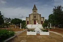
 Santa Rosa de Lima church | |
 Coat of arms | |
 La Romana | |
| Coordinates: 18°25′48″N 68°58′12″W | |
| Country | Dominican Republic |
| Province | La Romana |
| Municipal District | 1 |
| Area | |
| • Total | 276.36 km2 (106.70 sq mi) |
| • Urban | 25.54 km2 (9.86 sq mi) |
| Elevation | 10 m (30 ft) |
| Population (2014)[1] | |
| • Total | 130,426 |
| • Density | 470/km2 (1,200/sq mi) |
| • Urban | 127,623 |
| Demonym | Romanense |
| Time zone | UTC-4 (AST) |
| • Summer (DST) | UTC-4 (AST) |
| Distance | 35 km (22 mi) to Higüey 210 km (130 mi) to Santo Domingo |
The town was built on the right (western) side of the mouth of the river Dulce (now also called Romana).
Population
The municipality had, in 2014, a total population of 130,426: 63,261 men and 67,165 women. The urban population was 97.9% of the total population, one of the most urban municipality in the country.[1]
Geography
La Romana is in the region known as Llano Costero del Caribe (in English, "Caribbean Coastal Plain"), with only few low hills and many savannas. The small islands of Catalina and Saona are part of this municipality but nobody lives in Catalina.
The municipality has a total area of 276.36 km2 (106.7 sq mi). It has only one municipal district (a subdivision of a municipality): Caleta.[1]
La Romana has the municipality of Guaymate to the north, the La Altagracia province to the east, the Caribbean Sea to the south and the Villa Hermosa municipality to the west.
The altitude of the city of La Romana is 10 m (33 ft) above sea level.[3] The city is at 210 km (130 mi) to the east of Santo Domingo and at 35 km (22 mi) of Higüey.
Climate
La Romana has a tropical wet and dry/ savanna climate (Köppen climate classification : Aw) with a pronounced dry season in winter.[4]
The average amount of rainfall for the year in the city is 872.5 mm (34.4 in). The month with the most precipitation on average is October with 164.6 mm (6.5 in) of rainfall, followed by September with 116.8 mm (4.6 in).
The driest season is winter. The month with the least rainfall on average is March with an average of 27.5 mm (1.1 in) and the second is February with 27.8 mm (1.1 in).
La Romana is in a warm region; the average temperature for the year is 26.3 °C (79 °F). The warmest month, on average, is July with an average temperature of 27.95 °C (82.3 °F). The coolest month on average is January, with an average temperature of 24.6 °C (76.28 °F).
| Climate data for La Romana (1961–1990) | |||||||||||||
|---|---|---|---|---|---|---|---|---|---|---|---|---|---|
| Month | Jan | Feb | Mar | Apr | May | Jun | Jul | Aug | Sep | Oct | Nov | Dec | Year |
| Average high °C (°F) | 29.7 (85.5) |
30 (86) |
30.5 (86.9) |
30.9 (87.6) |
31.2 (88.2) |
32 (90) |
32.7 (90.9) |
32.6 (90.7) |
32.2 (90.0) |
31.8 (89.2) |
30.8 (87.4) |
29.9 (85.8) |
31.2 (88.2) |
| Daily mean °C (°F) | 24.6 (76.3) |
24.8 (76.6) |
25.2 (77.4) |
25.7 (78.3) |
26.6 (79.9) |
27.5 (81.5) |
28 (82) |
27.9 (82.2) |
27.6 (81.7) |
27.2 (81.0) |
26.2 (79.2) |
25.1 (77.2) |
26.4 (79.4) |
| Average low °C (°F) | 19.5 (67.1) |
19.5 (67.1) |
19.8 (67.6) |
20.5 (68.9) |
22 (72) |
22.9 (73.2) |
23.2 (73.8) |
23.32 (73.98) |
22.9 (73.2) |
22.6 (72.7) |
21.6 (70.9) |
20.2 (68.4) |
21.50 (70.74) |
| Average rainfall mm (inches) | 32.7 (1.29) |
27.8 (1.09) |
27.5 (1.08) |
45.2 (1.78) |
91 (3.6) |
57 (2.2) |
60.9 (2.40) |
105.2 (4.14) |
116.8 (4.60) |
164.6 (6.48) |
96.2 (3.79) |
47.6 (1.87) |
872.5 (34.32) |
| Source 1: NOAA[5] | |||||||||||||
| Source 2: Climatemps.com[4] | |||||||||||||
Administrative division
The municipality of La Romana has only one municipal district:[1]
| Code | Municipal district | Population (2010) |
|---|---|---|
| 120102 | Caleta | 9,245 |
Economy
The most important company in La Romana is the Central Romana that produces sugar. This factory was built in 1917 by the South Puerto Rico Sugar Company.
There is also here an important Free Trade Zone, a place where there are different companies that made different products to send to other countries and do not pay taxes in the Dominican Republic.
The La Romana International Airport is very near the city and there are several important tourist places such as : Casa de Campo and Alto de Chavón.
Sugarcane is an important crop in the municipality and also cattle raising.
References
- Consejo Nacional de Población y Familia. "Estamaciones y Proyecciones de la Población Dominicana por Regiones, Provincias, Municipios y Distritos Municipales, 2014" (PDF) (in Spanish). Retrieved 2014-02-02.
- "Expansión Urbana de las ciudades capitales de R.D. 1988-2010. Informe Básico" (PDF) (in Spanish). Oficina Nacional de Estadística. April 2015. p. 46. Retrieved 9 December 2016.
- De la Fuente, Santiago (1976). Geografía Dominicana (in Spanish). Santo Domingo, Dominican Republic: Editora Colegial Quisqueyana.
- "La Romana Climate & Temperature". Climatemps.com. Retrieved 3 November 2016.
- "La Romana Climate Normals 1961-1990". National Oceanic and Atmospheric Administration. Retrieved 3 November 2016.
| Provincial capitals of the Dominican Republic | |
|---|---|
| Azua • Baní • Barahona • Bonao • Comendador • Cotuí • Dajabón • El Seibo • Hato Mayor • Higüey • Jimaní • La Romana • La Vega • Mao • Moca • Monte Cristi • Monte Plata • Nagua • Neiba • Pedernales • Puerto Plata • Sabaneta • Salcedo • Samaná • San Cristóbal • San Francisco de Macorís • San José de Ocoa • San Juan de la Maguana • San Pedro de Macorís • Santiago de los Caballeros • Santo Domingo • Santo Domingo Este | |