Rankin County, Mississippi
Rankin County is a county in the U.S. state of Mississippi. As of the 2020 census, 157,031 people lived there,[1] which makes it the fourth-most populous county in Mississippi. Its county seat is Brandon.[2]
Rankin County | |
|---|---|
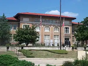
 Rankin County Courthouse in Brandon | |
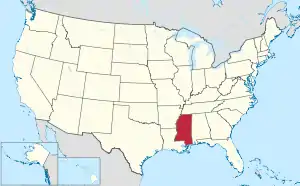
 Location within the U.S. state of Mississippi | |
 Mississippi's location within the U.S. | |
| Coordinates: 32°16′N 89°57′W | |
| Country | |
| State | |
| Founded | February 4, 1828 |
| Named for | Christopher Rankin |
| Seat | Brandon |
| Largest city | Pearl |
| Area | |
| • Total | 806 sq mi (2,090 km2) |
| • Land | 775 sq mi (2,010 km2) |
| • Water | 31 sq mi (80 km2) 3.8% |
| Population (2020) | |
| • Total | 157,031 |
| • Density | 190/sq mi (75/km2) |
| Time zone | UTC−6 (Central) |
| • Summer (DST) | UTC−5 (CDT) |
| Congressional district | 3rd |
| Website | www |
Rankin County is part of the Jackson Metropolitan Statistical Area.
History
Rankin County was founded on February 4, 1828. It is named in honor of Christopher Rankin, a Mississippi Congressman from 1819 to 1826.
Geography
According to the U.S. Census Bureau says that the county has a total area of 806 square miles (2,090 km2). Of that 775 square miles (2,010 km2) is land and 31 square miles (80 km2) (3.8%) is water.[3]
Bordering counties
- Madison County (north)
- Scott County (east)
- Smith County (southeast)
- Simpson County (south)
- Hinds County (west)
Demographics
| Historical population | |||
|---|---|---|---|
| Census | Pop. | %± | |
| 1830 | 2,083 | — | |
| 1840 | 4,631 | 122.3% | |
| 1850 | 7,227 | 56.1% | |
| 1860 | 13,635 | 88.7% | |
| 1870 | 12,977 | −4.8% | |
| 1880 | 16,752 | 29.1% | |
| 1890 | 17,922 | 7.0% | |
| 1900 | 20,955 | 16.9% | |
| 1910 | 23,944 | 14.3% | |
| 1920 | 20,272 | −15.3% | |
| 1930 | 20,353 | 0.4% | |
| 1940 | 27,934 | 37.2% | |
| 1950 | 28,881 | 3.4% | |
| 1960 | 34,322 | 18.8% | |
| 1970 | 43,933 | 28.0% | |
| 1980 | 69,427 | 58.0% | |
| 1990 | 87,161 | 25.5% | |
| 2000 | 115,327 | 32.3% | |
| 2010 | 141,617 | 22.8% | |
| 2020 | 157,031 | 10.9% | |
| U.S. Decennial Census[4] 1790-1960[5] 1900-1990[6] 1990-2000[7] 2010-2020[1] | |||
As of the 2020 census, there were 157,031 people, 59,626 households, and 41,940 families living in the county.[1][8]
Transportation
Major highways
 Interstate 20
 U.S. Highway 80
 U.S. Highway 49
 Mississippi Highway 13
 Mississippi Highway 18
 Mississippi Highway 25
 Mississippi Highway 43
 Mississippi Highway 471
 Interstate 55
Airport
Jackson Evers International Airport is located in unincorporated Rankin County.
Communities
Cities
- Brandon (county seat)
- Flowood
- Jackson (mostly in Hinds County, also in Madison County)
- Pearl
- Richland
Towns
Village
Census-designated places
- Cleary
- Robin Hood
Other unincorporated communities
- Cross Roads
- Fannin
- Goshen Springs
- Greenfield
- Gulde
- Jesus
- Johns
- Langford
- Leesburg
- Piney Woods
- Sand Hill
- Star
- Whitfield
- Pisgah
Former communities
- Cato
- Comeby
- Crossgates Farm
- Dobson
- Robinhood/Shady Lakes
- Value
References
- "QuickFacts: Rankin County, Mississippi". United States Census Bureau. Retrieved January 4, 2024.
- "Find a County". National Association of Counties. Retrieved 2011-06-07.
- "2010 Census Gazetteer Files". United States Census Bureau. August 22, 2012. Archived from the original on September 28, 2013. Retrieved November 7, 2014.
- "U.S. Decennial Census". United States Census Bureau. Retrieved November 7, 2014.
- "Historical Census Browser". University of Virginia Library. Archived from the original on August 11, 2012. Retrieved November 7, 2014.
- "Population of Counties by Decennial Census: 1900 to 1990". United States Census Bureau. Retrieved November 7, 2014.
- "Census 2000 PHC-T-4. Ranking Tables for Counties: 1990 and 2000" (PDF). United States Census Bureau. Archived (PDF) from the original on 2010-03-27. Retrieved November 7, 2014.
- "P16: HOUSEHOLD TYPE". United States Census Bureau. Retrieved January 2, 2024.