Puntarenas Province
Puntarenas is a province of Costa Rica. It is in the western part of the country, covering most the Pacific Ocean coast of Costa Rica. The provincial capital is the city of Puntarenas.
Province of Puntarenas
Provincia de Puntarenas | |
|---|---|
 Cultural Centre of Puntarenas | |
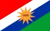 Flag  Coat of arms | |
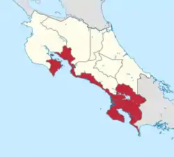 Location of the Province of Puntarenas | |
| Coordinates: 9°58′N 84°50′W | |
| Country | Costa Rica |
| Capital city | Puntarenas |
| Area | |
| • Total | 11,265.69 km2 (4,349.71 sq mi) |
| Population (2011)[2] | |
| • Total | 410,929 |
| • Density | 36/km2 (94/sq mi) |
| Demonym | Puntarenense |
| ISO 3166 code | CR-P |
Location
The Puntarenas province borders with the Alajuela, San José and Limón provinces to the north, with Panama to the east; with the Pacific Ocean to the south, and with the Pacific Ocean and the Guanacaste to the west.[1]
Places next to Puntarenas Province | ||||||||||
|---|---|---|---|---|---|---|---|---|---|---|
| ||||||||||
Geography
Puntarenas is in the western part of the country, covering most of Costa Rica's Pacific Ocean coast, and is the largest province of Costa Rica. It is the province with more islands: Chira, Bejuco, Caballo, Venado, Cedros, Cuchillos, Negritos, San Lucas, Herradura, Violín, Isla del Caño and the Coco Island. The province has an area of 11,265.69 km2 (4,349.71 sq mi).[1]
The highest mountain in the province is the Cerro Dúrika on the border with the Limón province; it is 3,280 m (10,760 ft) high (9°22′32″N 83°18′18″W).[3]
Some of the rivers that flow through the province are Ario, Lagarto, Barranca, Grande de Tárcoles, Grande de Térraba, General, Coto Brus, Naranjo, Barú, Parrita, Savegre, Aranjuez and Coto.[4]
Demographics
A person from the province is known as puntarenense (men and women).[4]
The Puntarenas province had a population, in 2011, of 410,929 for a population density of 1.9 inhabitants/km2. The canton of Puntarenas, with 115,019 inhabitants, is the canton with more inhabitants.[2]
Evolution of the population in Puntarenas[2]

Administrative divisions
The Puntarenas province is divided in 11 cantons, which are divided into 60 Districts.[2]

| No. | Canton | Capital | Districts[5] | Population (2011) | Area (km²) | Density (inh./km²) |
|---|---|---|---|---|---|---|
| 1 | Puntarenas | Puntarenas | 16 | 115,019 | 1,842.33 | 62.4 |
| 2 | Esparza | Espíritu Santo | 6 | 28,644 | 216.80 | 132.1 |
| 3 | Buenos Aires | Buenos Aires | 9 | 45,244 | 2,384.22 | 19.0 |
| 4 | Montes de Oro | Miramar | 3 | 12,950 | 244.76 | 52.9 |
| 5 | Osa | Ciudad Cortés | 6 | 29,433 | 1,930.24 | 15.2 |
| 6 | Quepos | Quepos | 3 | 26,861 | 543.77 | 49.4 |
| 7 | Golfito | Golfito | 4 | 39,150 | 1,753.96 | 22.3 |
| 8 | Coto Brus | San Vito | 6 | 38,453 | 933.91 | 41.2 |
| 9 | Parrita | Parrita | 1 | 16,115 | 478.79 | 33.7 |
| 10 | Corredores | Ciudad Neily | 4 | 41,831 | 620.60 | 67.4 |
| 11 | Garabito | Jacó | 2 | 17,229 | 316.31 | 54.5 |


References
- "Anuario Estadístico 2012 - 2013" (PDF) (in Spanish). San José, Costa Rica: Instituto Nacional de Estadística y Censos (INEC). June 2015. p. 49. Archived from the original (PDF) on 14 November 2016. Retrieved 5 February 2017.
- "Anuario Estadístico 2012 - 2013" (PDF) (in Spanish). San José, Costa Rica: Instituto Nacional de Estadística y Censos (INEC). June 2015. p. 103. Archived from the original (PDF) on 14 November 2016. Retrieved 5 February 2017.
- "Cerro Dúrika, Costa Rica". Peakbagger.com. Retrieved 5 February 2017.
- "Provincia: Puntarenas" (in Spanish). Guías Costa Rica. Retrieved 5 February 2017.
- "División Territorial Administrativa de la República de Costa Rica" (PDF) (in Spanish). San José, Costa Rica: Diario Oficial La Gaceta. 12 November 2015. Archived from the original (PDF) on 5 October 2016. Retrieved 6 February 2017.