Alajuela Province
Alajuela is a province of Costa Rica. It is in the north-central part of the country, bordering Nicaragua. The provincial capital is the city of Alajuela.
Province of Alajuela
Provincia de Alajuela | |
|---|---|
 Alajuela cathedral | |
 Flag  Coat of arms | |
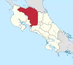 Location of the Province of Alajuela | |
| Coordinates: 10°34′N 84°36′W | |
| Country | Costa Rica |
| Founded | 12 October 1782 |
| Capital city | Alajuela |
| Area | |
| • Total | 9,757.53 km2 (3,767.40 sq mi) |
| Population (2011)[2] | |
| • Total | 848,146 |
| • Density | 87/km2 (230/sq mi) |
| Demonym | Alajuelense |
| ISO 3166 code | CR-A |
Location
The Alajuela province borders the provinces of Heredia to the east, San José to the south, Puntarenas to the southwest and Guanacaste to the west. Nicaragua is to the north of the province.
Places next to Alajuela Province | ||||||||||
|---|---|---|---|---|---|---|---|---|---|---|
| ||||||||||
Geography
Alajuela is the third largest province of Costa Rica, after the Puntarenas and Guanacaste provinces, with an area of 9,757.53 km2 (3,767.40 sq mi).[1]
The province is in the western part of the Central Valley and is crossed by the Cordillera Central ("Central mountain range) and the volcanic Cordillera de Guanacaste ("Guanacaste mountain range). In the northern part, along the border with Nicaragua, are the plains of the San Carlos and Frío rivers.
Two of the most active Costa Rican volcanoes are in this province: the Poás, 2,708 m (8,885 ft) high, and the Arenal, 1,630 m (5,350 ft) high.[1]
Demographics

The people of the province are known as Alajuelenses, both men and women.
The Alajuela province had a population, in 2011, of 848,146, for a population density of 86.9 inhabitants/km2. The canton of Alajuela, with 254,886 inhabitants, is the canton with more inhabitants.[2]
Evolution of the population in Alajuela[2]

Administrative divisions
The Alajuela province is divided in 15 cantons, which are divided into 113 Districts.[3]
| No. | Canton | Capital | Districts | Population (2011) | Area (km²) | Density (Inh./km²) |
|---|---|---|---|---|---|---|
| 1 | Alajuela | Alajuela | 14 | 254,886 | 388.43 | 656.2 |
| 2 | San Ramón | San Ramón de los Palmares | 13 | 80,566 | 395.72 | 203.6 |
| 3 | Grecia | Grecia | 8 | 76,898 | 395.72 | 194.3 |
| 4 | San Mateo | San Mateo de Alajuela | 4 | 6,136 | 125.90 | 48.7 |
| 5 | Atenas | Atenas | 8 | 25,460 | 127.19 | 200.2 |
| 6 | Naranjo | Naranjo de Alajuela | 8 | 42,713 | 126.62 | 337.3 |
| 7 | Palmares | Palmares de Alajuela | 7 | 34,716 | 38.06 | 912.1 |
| 8 | Poás | San Pedro de Poás | 5 | 29,199 | 73.84 | 395.4 |
| 9 | Orotina | Orotina | 5 | 20,341 | 141.92 | 143.3 |
| 10 | San Carlos | Ciudad Quesada | 13 | 163,745 | 3,347.98 | 48.9 |
| 11 | Zarcero | Zarcero | 7 | 12,205 | 155.13 | 78.7 |
| 12 | Valverde Vega | Sarchí | 5 | 18,085 | 120.25 | 150.4 |
| 13 | Upala | Upala | 8 | 43,953 | 1,580.67 | 27.8 |
| 14 | Los Chiles | Los Chiles | 4 | 23,735 | 1,358.86 | 17.5 |
| 15 | Guatuso | San Rafael de Guatuso | 4 | 15,508 | 758.32 | 20.5 |
Economy
The main economic activity in the province is farming. In the southern part of the province, tropical ornamentals, coffee, tubers, and Leaf vegetables are the major crops. Toward the north and northeast, rice, corn, pineapple, bananas, and sugarcane are important crops.
There is also an important cattle raising industry in the province, mainly in the San Carlos canton.
Alajuela has attracted many export-orientated manufacturing companies, especially within the free trade zones around the municipality of Alajuela.
Gallery
 World's Largest Oxcart, Sarchí, Valverde Vega.
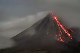 The Arenal Volcano in La Fortuna, San Carlos, is active. Night volcanic eruptions can be seen.
References
- "Anuario Estadístico 2012 - 2013" (PDF) (in Spanish). San José, Costa Rica: Instituto Nacional de Estadística y Censos (INEC). June 2015. Archived from the original (PDF) on 14 November 2016. Retrieved 11 December 2016.
- "Anuario Estadístico 2012 - 2013" (PDF) (in Spanish). San José, Costa Rica: Instituto Nacional de Estadística y Censos (INEC). June 2015. p. 102. Archived from the original (PDF) on 14 November 2016. Retrieved 11 December 2016.
- "Anuario Estadístico 2012 - 2013" (PDF) (in Spanish). San José, Costa Rica: Instituto Nacional de Estadística y Censos (INEC). June 2015. p. 51. Archived from the original (PDF) on 14 November 2016. Retrieved 11 December 2016.