Provinces of South Africa
South Africa has nine provinces.[1]
| Provinces of South Africa | |
|---|---|
| Category | Regional state |
| Location | South Africa |
| Created | 27 April 1994 |
| Number | 9 Provinces |
| Populations | 1,355,946 (Northern Cape) – 15,099,422 (Gauteng) |
| Areas | 18,178 km2 (7,019 sq mi) (Gauteng) – 372,889 km2 (143,973 sq mi) (Northern Cape) |
| Government |
|
| Subdivisions | Districts Metropolitan municipality |
Just before the 1994 general election, the number of provinces went up from four to nine, because all the Bantustans became provinces.
Provinces have their own government, led by a Premier.
List
| Province | Name in the most spoken native language[2] | Capital | Largest city | Area[3]: 9 | Population (2022)[4] |
Density (2022) |
Map |
|---|---|---|---|---|---|---|---|
| Eastern Cape | iMpuma-Koloni (Xhosa) | Bhisho (Bisho) | Gqeberha (Port Elizabeth) | 168,966 km2 (65,238 sq mi) | 7,230,204 | 42.8/km2 (111/sq mi) | 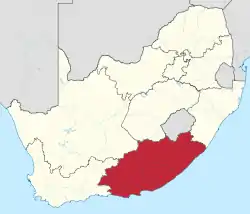 |
| Free State | Freistata (Sotho) | Bloemfontein | Bloemfontein | 129,825 km2 (50,126 sq mi) | 2,964,412 | 22.8/km2 (59/sq mi) |  |
| Gauteng | eGoli (Zulu) | Johannesburg | Johannesburg | 18,178 km2 (7,019 sq mi) | 15,099,422 | 830.6/km2 (2,151/sq mi) |  |
| KwaZulu-Natal | iKwaZulu-Natali (Zulu) | Pietermaritzburg[n 1] | Durban | 94,361 km2 (36,433 sq mi) | 12,423,907 | 131.7/km2 (341/sq mi) |  |
| Limpopo | Limpopo (Pedi) | Polokwane (Pietersburg) | Polokwane | 125,754 km2 (48,554 sq mi) | 6,572,720 | 52.3/km2 (135/sq mi) |  |
| Mpumalanga | iMpumalanga (Swazi) | Mbombela (Nelspruit) | Mbombela | 76,495 km2 (29,535 sq mi) | 5,143,324 | 67.2/km2 (174/sq mi) | 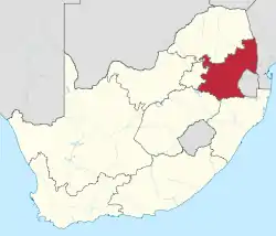 |
| North West | Bokone Bophirima (Tswana) | Mahikeng (Mafikeng) | Rustenburg | 104,882 km2 (40,495 sq mi) | 3,804,548 | 36.3/km2 (94/sq mi) | 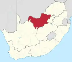 |
| Northern Cape | Noord-Kaap (Afrikaans) | Kimberley | Kimberley | 372,889 km2 (143,973 sq mi) | 1,355,946 | 3.6/km2 (9.3/sq mi) |  |
| Western Cape[n 2] | Wes-Kaap (Afrikaans) | Cape Town | Cape Town | 129,462 km2 (49,986 sq mi) | 7,433,019 | 57.4/km2 (149/sq mi) | 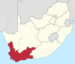 |
| Republic of South Africa | iRiphabhuliki yaseNingizimu Afrika (Zulu) | Pretoria, Bloemfontein Cape Town[n 3][5] | Johannesburg | 1,220,813 km2 (471,359 sq mi) | 62,027,503 | 50.8/km2 (132/sq mi) |  |
Footnotes:
- Pietermaritzburg and Ulundi were joint capitals of KwaZulu-Natal from 1994 to 2004.
- These statistics do not include the Prince Edward Islands (335 km2 or 129 sq mi, with no permanent residents), which are South African territories in the sub-Antarctic Indian Ocean but part of the Western Cape for legal and electoral purposes.
- Parliament sits in Cape Town, the Supreme Court of Appeal in Bloemfontein, and the Executive branch in Pretoria.
Provincial acronyms
| Province | HASC | ISO | FIPS | CSS | Conventional |
|---|---|---|---|---|---|
| Eastern Cape | ZA.EC | EC | SF05 | 02 | EC |
| Free State | ZA.FS | FS | SF03 | 04 | FS |
| Gauteng | ZA.GT | GP | SF06 | 07 | GP |
| KwaZulu-Natal | ZA.NL | KZN | SF02 | 05 | KZN |
| Limpopo | ZA.NP | LP | SF09 | 09 | LP |
| Mpumalanga | ZA.MP | MP | SF07 | 08 | MP |
| Northern Cape | ZA.NC | NC | SF08 | 03 | NC |
| North-West | ZA.NW | NW | SF10 | 06 | NW |
| Western Cape | ZA.WC | WC | SF11 | 01 | WC |
| Notes HASC: Hierarchical administrative subdivision codes | |||||
Former administrative divisions
| Province | Capital | Peak population | Location |
|---|---|---|---|
| Cape of Good Hope (1910–1994) | Cape Town | 6,125,335 | |
| Natal (1910–1994) | Pietermaritzburg | 2,430,753 | |
| Orange Free State (1910–1994) | Bloemfontein | 2,193,062 | |
| Transvaal (1910–1994) | Pretoria | 9,491,265 | |
| Homelands | Capital | Peak population | Location |
| Bophuthatswana (1977–1994) † | Mmabatho | 1,478,950 | |
| Ciskei (1972–1994) † | Bisho | 677,920 | |
| Gazankulu (1971–1994) | Giyani | 954,771 | |
| KaNgwane (1981–1994) | Louieville Schoemansdal (de facto) | 779,240 | |
| KwaNdebele (1981–1994) | KwaMhlanga | 404,246 | |
| KwaZulu (1981–1994) | Nongoma (until 1980) Ulundi (1980–1994) | 5,524,774 | |
| Lebowa (1972–1994) | Lebowakgomo | 2,740,587 | |
| QwaQwa (1974–1994) | Phuthaditjhaba | 342,886 | |
| Transkei (1976–1994) † | Umtata | 2,323,650 | |
| Venda (1979–1994) † | Thohoyandou | 558,797 | |
| Mandates | Capital | Peak population | |
| South West Africa | Windhoek | 1,415,000 |
Footnotes:
- † States for which the homeland was quasi-independent.
References
- https://southafrica-info.com/land/nine-provinces-south-africa/
- http://www.statssa.gov.za/census/census_2011/census_products/Census_2011_Census_in_brief.pdf, p. 25.
- Census 2011: Census in brief (PDF). Pretoria: Statistics South Africa. 2012. p. 30. ISBN 9780621413885. Archived (PDF) from the original on 13 May 2015.
- Census 2022: Statistical release (PDF) (Report). Pretoria: Statistics South Africa. 2023. p. 3.
- "How Many Capital Cities Does South Africa Have?".
- "South African Provinces".
| |||||||
| Provinces | |||||||
| Municipalities |
| ||||||
| Settlements |
| ||||||
This article is issued from Wikipedia. The text is licensed under Creative Commons - Attribution - Sharealike. Additional terms may apply for the media files.