Namie, Fukushima
Namie (浪江町, Namie-machi) is a Japanese town in Fukushima Prefecture on the island of Honshu.
Namie
浪江町 | |
|---|---|
Town | |
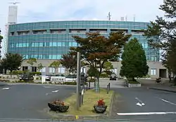 Namie Town Hall | |
 Flag  Seal | |
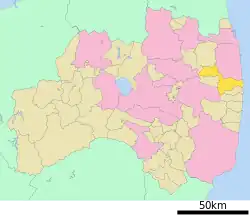 Location of Namie in Fukushima Prefecture | |
 Namie | |
| Coordinates: 37°29′40.5″N 141°00′2.6″E | |
| Country | Japan |
| Region | Tōhoku |
| Prefecture | Fukushima |
| District | Futaba |
| Area | |
| • Total | 223.14 km2 (86.15 sq mi) |
| Population (October 2017) | |
| • Total | 0 |
| • Density | 0/km2 (0/sq mi) |
| Time zone | UTC+9 (Japan Standard Time) |
| - Tree | Pine |
| - Flower | Cosmos |
| - Bird | Common gull |
| Phone number | 0243-62-0123 |
| Address | Kiyohashi Rokutanda 7-2, Namie-machi, Futaba-gun, Fukushima-ken 979-1592 |
| Website | http://www.town.namie.fukushima.jp/ |
History
Namie was damaged in the 2011 Tōhoku earthquake and tsunami.
In April 2011, the Japanese government made people leave here because of radiation from the Fukushima I nuclear accidents.
Before people left, stone from a quarry in Namie was sent to make concrete for about 60 buildings. The stone and the concrete is radioactive.[1]
The people who used to live in Namie are called "nuclear refugees".[2]
Gallery
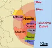 Fukushima disaster evacuation zones
References
- "Radioactive crushed stone may have been used in over 80 buildings, METI says,"Japan Today, 23 January 2012;.
- "'Nuclear refugees' visit their home near stricken Fukushima plant," NBC News. 7 March 2013; retrieved 2013-3-12.
Other websites
Wikimedia Commons has media related to Namie, Fukushima.
- Namie official website (in Japanese)
- Translated to English Archived 2016-06-19 at the Wayback Machine by Google
| Cities | Aizuwakamatsu | Date | Fukushima (capital) | Iwaki | Kitakata | Kōriyama | Minamisōma | Motomiya | Nihonmatsu | Shirakawa | Sōma | Sukagawa | Tamura | |
|---|---|---|
| Districts | Adachi | Date | Futaba | Higashishirakawa | Ishikawa | Iwase | Kawanuma | Minamiaizu | Nishishirakawa | Ōnuma | Sōma | Tamura | Yama | |
See also: Towns and villages by district | ||

This article is issued from Wikipedia. The text is licensed under Creative Commons - Attribution - Sharealike. Additional terms may apply for the media files.