Mid-Western Development Region, Nepal
Mid-Western Development Region (Nepali: मध्य पश्चिमाञ्चल विकास क्षेत्र - Madhya Pashchimānchal Bikās Kshetra) was one of Nepal's five development regions. It was in the west-central part of the country. Its headquarters were at Birendranagar, Surkhet.
मध्य-पश्चिमाञ्चल विकास क्षेत्र
Madhya-Pashchimānchal Bikās Kshetraa | |
|---|---|
 | |
| Coordinates: 28°36′N 81°38′E | |
| Country | |
| Region | Mid-Western Development Region |
| Headquarters | Birendranagar, Surkhet District, Bheri Zone |
| Area | |
| • Total | 42,378 km2 (16,362 sq mi) |
| Population (2011 Census) | |
| • Total | 3,546,682 |
| • Density | 84/km2 (220/sq mi) |
| pop.note | |
| Time zone | UTC+5:45 (NPT) |
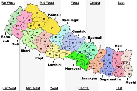
Geography
The Mid-Western Development Region had the Western Development Region to the east, Uttar Pradesh (India) to the south, the Far-Western Development Region to the west and the Tibet Autonomous Region (People's Republic of China) to the north.
Places next to Mid-Western Development Region, Nepal | |
|---|---|
It was the largest Development Region of Nepal with an area of 42,378 square kilometres (16,362 square miles). It was the fourth in population with 3,546,682 people living there in 2011.[1] Its population density was the lowest of all the regions, with 83.7 persons/km2.
The most important river in the Mid-Western Development Region was the Karnali or Kauriala, known as Ghaghara in India. It is an important left tributary of the Ganges river. Its length in Nepal is 507 kilometres (315 miles), the largest river of the country.
Some of the tributaries of the Karnali are the Humla Karnali , west Rapti, Tila karnali, Bheri
The biggest lake of Nepal, Lake Rara, was in this region, in the Mugu district of the Karnali Zone.
Cities
Some cities of this region were Birendranagar, Chinchu, Babiyachour, Tribhuvannagar (Ghorahi), Nepalgunj, and Tulsipur.
Administrative subdivisions
The region had 3 Zones with a total of 15 Districts:
| Zone | Population[2] (2011) |
Area[3] (km²) |
Pop. density (inh/km²) |
Districts | |
|---|---|---|---|---|---|
| Number | Names | ||||
| Bheri | 1,701,767 | 10,545 | 161.4 | 5 | Banke, Bardiya, Dailekh, Jajarkot, Surkhet |
| Karnali | 388,713 | 21,351 | 18.2 | 5 | Dolpa, Humla, Jumla, Kalikot, Mugu |
| Rapti | 1,456,202 | 10,482 | 138.9 | 5 | Dang Deokhuri, Pyuthan, Rolpa, Rukum, Salyan |
| Total | 3,546,682 | 42,378 | 83.7 | 15 | |
References
- "National Population and Housing Census 2011" (PDF). Central Bureau of Statistics. Kathmandu, Nepal. November 2012. Archived from the original (pdf) on 28 December 2013. Retrieved 12 October 2013.
- "Nepal: Administrative Division". City Population. Retrieved 12 October 2013.
- "Regions of Nepal". Statoids. 2012-12-07. Retrieved 12 October 2013.