Laar
Laar is a community in Bentheim in Lower Saxony.
Laar | |
|---|---|
 Coat of arms | |
Location of Laar within Grafschaft Bentheim district 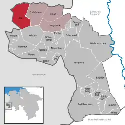 | |
 Laar 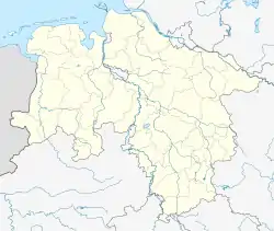 Laar | |
| Coordinates: 52°37′00″N 06°43′59″E | |
| Country | Germany |
| State | Lower Saxony |
| District | Grafschaft Bentheim |
| Municipal assoc. | Emlichheim |
| Government | |
| • Mayor | Gerhard Trüün (CDU) |
| Area | |
| • Total | 51.01 km2 (19.70 sq mi) |
| Elevation | 9 m (30 ft) |
| Population (2022-12-31)[1] | |
| • Total | 2,128 |
| • Density | 42/km2 (110/sq mi) |
| Time zone | UTC+01:00 (CET) |
| • Summer (DST) | UTC+02:00 (CEST) |
| Postal codes | 49824 |
| Dialling codes | 05947 |
| Vehicle registration | NOH |
Geography
Place
Laar is northwest of Nordhorn on the German-Dutch border. It belongs to the Joint Community (Samtgemeinde) of Emlichheim, whose administrative seat is in the like-named town. The Vechte runs through the community.
Neighbouring communities
The community of Laar borders in the south on the communities of Wielen and Wilsum, in the east on the community of Emlichheim, in the north on the Dutch community of Coevorden and in the west on the Dutch community of Hardenberg in Overijssel.
Constituent communities
The community of Laar has the six constituent centres (Ortsteile) of Agterhorn, Echteler, Eschebrügge, Heesterkante, Laar and Vorwald.
References
Other websites
- Official website
 (in German)
This article is issued from Wikipedia. The text is licensed under Creative Commons - Attribution - Sharealike. Additional terms may apply for the media files.