Iitate, Fukushima
Iitate (飯舘村, Iitate-mura) is a village in Sōma District, Fukushima, Japan.
Iitate
飯舘村 | |
|---|---|
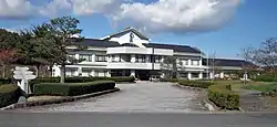 Iitate Village Office | |
 Flag  Seal | |
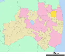 Location of Iitate in Fukushima Prefecture | |
 Iitate | |
| Coordinates: 37°40′44.4″N 140°44′06.8″E | |
| Country | Japan |
| Region | Tōhoku |
| Prefecture | Fukushima |
| District | Sōma |
| Area | |
| • Total | 230.13 km2 (88.85 sq mi) |
| Population (May 1, 2017) | |
| • Total | 41 |
| • Density | 0.18/km2 (0.5/sq mi) |
| Time zone | UTC+9 (Japan Standard Time) |
| - Tree | Pinus densiflora |
| - Flower | Lilium auratum |
| - Bird | Japanese bush-warbler |
| Phone number | 24-562-4200 |
| Address | 580-1 Itazawa, Iitate-mura, Soma-gun, Fukushima-ken 960-1892 |
| Website | http://www.vill.iitate.fukushima.jp/ |
Other websites
![]() Media related to Iitate, Fukushima at Wikimedia Commons
Media related to Iitate, Fukushima at Wikimedia Commons
- Iitate official website (in Japanese)
| Cities | Aizuwakamatsu | Date | Fukushima (capital) | Iwaki | Kitakata | Kōriyama | Minamisōma | Motomiya | Nihonmatsu | Shirakawa | Sōma | Sukagawa | Tamura | |
|---|---|---|
| Districts | Adachi | Date | Futaba | Higashishirakawa | Ishikawa | Iwase | Kawanuma | Minamiaizu | Nishishirakawa | Ōnuma | Sōma | Tamura | Yama | |
See also: Towns and villages by district | ||

This article is issued from Wikipedia. The text is licensed under Creative Commons - Attribution - Sharealike. Additional terms may apply for the media files.