Hemau
Hemau is a small town in Southern Germany, in Regensburg. The town is on the Tangrintel, a ridge which runs between the rivers Altmühl and Schwarze Laber.
Hemau | |
|---|---|
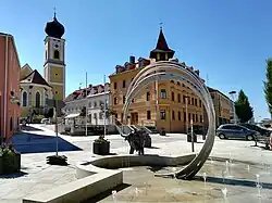 Town square with the Church of Saint John the Baptist | |
 Coat of arms | |
Location of Hemau within Regensburg district 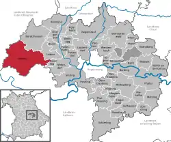 | |
 Hemau  Hemau | |
| Coordinates: 49°03′07″N 11°46′58″E | |
| Country | Germany |
| State | Bavaria |
| Admin. region | Oberpfalz |
| District | Regensburg |
| Subdivisions | 13 Ortsteile |
| Government | |
| • Mayor (2020–26) | Herbert Tischhöfer[1] (CSU) |
| Area | |
| • Total | 122.46 km2 (47.28 sq mi) |
| Elevation | 514 m (1,686 ft) |
| Population (2022-12-31)[2] | |
| • Total | 9,599 |
| • Density | 78/km2 (200/sq mi) |
| Time zone | UTC+01:00 (CET) |
| • Summer (DST) | UTC+02:00 (CEST) |
| Postal codes | 93155 |
| Dialling codes | 09491 |
| Vehicle registration | R |
| Website | www.hemau.de |
It is on the B8 road, 28 km (17 mi) north-west of Regensburg, 77 km (48 mi) south-east of Nuremberg. The nearest towns, about 5 km (3 mi) distant, are Beratzhausen and Laaber.
District Hemau
The district of Hemau is the largest in the Landkreis, and includes ten outlying villages which are parts of town, though they are not in the town of Hemau itself:
|
|
References
- Liste der ersten Bürgermeister/Oberbürgermeister in kreisangehörigen Gemeinden, Bayerisches Landesamt für Statistik, 15 July 2021.
- Genesis Online-Datenbank des Bayerischen Landesamtes für Statistik Tabelle 12411-003r Fortschreibung des Bevölkerungsstandes: Gemeinden, Stichtag (Einwohnerzahlen auf Grundlage des Zensus 2011) .
This article is issued from Wikipedia. The text is licensed under Creative Commons - Attribution - Sharealike. Additional terms may apply for the media files.